
Tag Archives: dusk

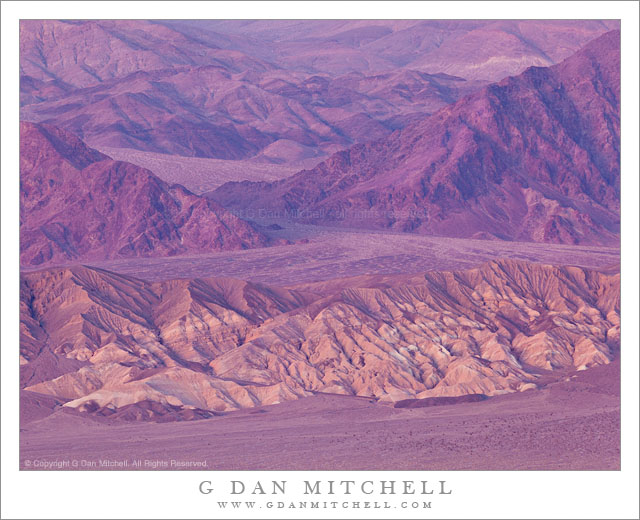
Kit Fox Hills and Death Valley Buttes, Dusk

Kit Fox Hills and Death Valley Buttes, Dusk - Post-sunset light on the Kit Fox Hills, Death Valley Buttes, and the slopes of the Grapevine Mountains, Death Valley National Park
Post-sunset light on the Kit Fox Hills, Death Valley Buttes, and the slopes of the Grapevine Mountains, Death Valley National Park

Kit Fox Hills and Death Valley Buttes, Dusk. Death Valley National Park, California. January 3, 2012. © Copyright 2012 G Dan Mitchell – all rights reserved.

Post-sunset light on the Kit Fox Hills, Death Valley Buttes, and the slopes of the Grapevine Mountains, Death Valley National Park.

The view of the eroded Kit Fox Hills and the larger masses of Death Valley Buttes beyond with ascending ridges and valleys of the Amargosa Range beyond is one that I’ve been working on for a few years now. During the day these formations are interesting, but in many ways not much more so than any of scores of other hills, washes, rocky ridges and so forth throughout the park and other desert areas. But sometimes the light does absolutely incredible things to these hills along the east side of the Valley.

I first saw this happen during a previous visit when evening clouds lit up in astonishing and almost surreal ways after the sun had set. As the sky to the west of Death Valley began to glow in the post-sunset light a wash of amazing and intense color began to fill the scene. I’m not even sure how to describe the color. Rose? Purple? Pink? Some combination of the three and more? At that time I was shooting from a small hill in a less visited portion of the Valley, and I I photographed a large “fan” along the base of huge mountains not far from Stovepipe Wells. While the colors in that photograph are, indeed, real, I have a heck of a time convincing people that this is the case. I end up doing so much explaining that I don’t show the photograph all that often!

This light is similar, though a bit less intense. The light was fading quickly at this point, and I only had a few moments of this particularly beautiful light, which might have been hard to see in person since it was getting late. I photographed this from yet another spot that it just a bit off the beaten track, though not far at all from some very popular areas. In fact, as I worked alone as the evening came on, I could swing my camera around and use my longest focal length to see hordes of people visiting and photographing another nearby feature, oblivious to the light in this spot far to their east.

G Dan Mitchell is a California photographer whose subjects include the Pacific coast, redwood forests, central California oak/grasslands, the Sierra Nevada, California deserts, urban landscapes, night photography, and more.
Blog | About | Flickr | Twitter | Facebook | Google+ | 500px.com | LinkedIn | Email

Text, photographs, and other media are © Copyright G Dan Mitchell (or others when indicated) and are not in the public domain and may not be used on websites, blogs, or in other media without advance permission from G Dan Mitchell.
Badwater Salt Flats, Evening

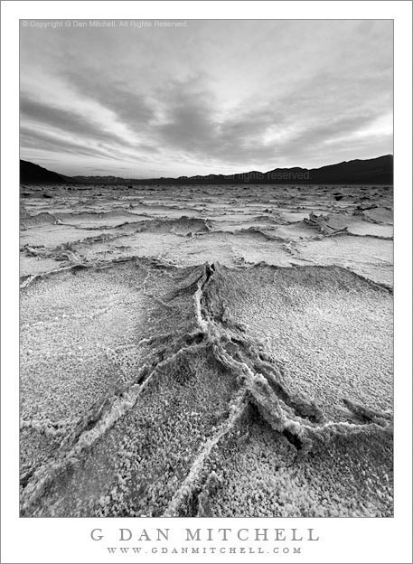
Badwater Salt Flats, Evening

Badwater Salt Flats, Evening. Death Valley National Park, California. March 31, 2009. © Copyright 2009 G Dan Mitchell – all rights reserved.

Black and white photograph of rough patterns in the dried salt desert floor at Badwater Salt Flats, Death Valley National Park.

This is another of the “rediscovered photographs” that I uncovered while reviewing many years of raw files recently. Periodically I go through all of the old archived raw files, partly to cull out a few that I know that I’ll never use, but also because I know that whenever I revisit the old files I discover some photographs that I had forgotten or had never understood at the time I made them. Revisiting the old file archives, I’m sometimes shocked that I passed over certain images.

This one is from the salt flats at Badwater in Death Valley National Park. Technically, this was not shot at precisely “Badwater,” but it is close enough. I was out on the flats in the late afternoon, shooting as the sun dropped behind the Panamint Range. In my view, the best light – with the exception of days when clouds might tower above the Panamints – comes starting right about at the time that the sun passes the line of the ridge as it descends at the end of the day. This takes the incredibly bright and harsh sun off of the playa and provides softer light in the shadow of the range. However, this also presents a problem that almost everyone who has shot here must understand, namely that the illumination by the bright blue sky turns the “white” salt a surprisingly intense blue color. I’ve seen people handle this in a variety of ways: keep the intense, almost gaudy, blue color; do a lot of color correction to get colors that more closely correspond to what we recall seeing; mostly include the sky with its more intense colors; or let the colors go and do a black and white rendition.

Although I’ve “done” this subject in color a number of times, somehow this one seemed to call out for black and white. For one thing, it allowed me to use the interesting shapes of the evening clouds as a dramatic backdrop to the rough and broken shapes of the playa salt polygons. It also allowed me to try an interpretation that focuses on the dramatic potential of the scene.

G Dan Mitchell is a California photographer whose subjects include the Pacific coast, redwood forests, central California oak/grasslands, the Sierra Nevada, California deserts, urban landscapes, night photography, and more.
Blog | About | Flickr | Twitter | Facebook | Google+ | 500px.com | LinkedIn | Email

Text, photographs, and other media are © Copyright G Dan Mitchell (or others when indicated) and are not in the public domain and may not be used on websites, blogs, or in other media without advance permission from G Dan Mitchell.
Sunset, Lower McCabe Lake, Shepherds Crest, and Virginia Canyon

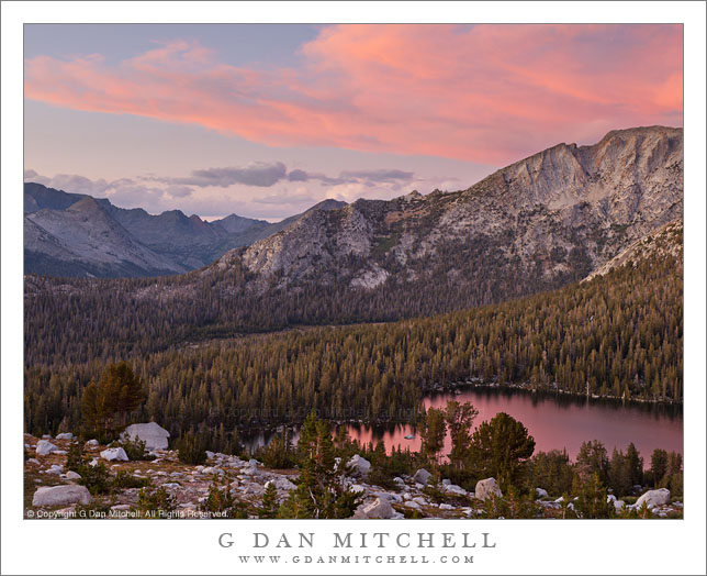
Sunset, Lower McCabe Lake, Shepherds Crest, and Virginia Canyon

Sunset, Lower McCabe Lake, Shepherds Crest, and Virginia Canyon. Yosemite National Park, California. September 19, 2011. © Copyright 2011 G Dan Mitchell – all rights reserved.

Afternoon storm clouds clear from the sunset sky above Lower McCabe Lake, Shepherds Crest, and Virginia Canyon, Yosemite National Park.

With this photograph I get to tell another of the “serendipitous photograph” stories that seem to keep coming up in my work. In this case, we had been camped near the lake in the lower area of the photograph for several days, getting to know the place and having time to carefully photograph various areas nearby. On a previous evening we had climbed to a second lake a few hundred feet higher than the “main” lake, from which one of our group decided to traverse a nearby slope. He ended up at another alpine lake that looked interesting, and the next morning others went with him to visit it. I didn’t, because I had some other things that I wanted to photograph in morning light and because I had a hunch that the light might turn out to be more interesting in the evening, mainly because the area of the lake was open to the west and, therefore, the evening light.

So in the evening, after our typical very early dinner, I departed on a walk to the upper lake that my friends had visited that morning, wandering around “our” lake and through the surrounding forest to pick up a rocky ramp that ascended toward the lake. However, I apparently missed a turn somewhere. I finished the main part of the climb and apparently should have turned left immediately – but I continued on straight ahead and soon found myself in a little meadowy area with a rather steep bunch of rocks between me and my goal. I finally found a circuitous route up a series of ramps, but now it was getting too close to sunset and my turn-around time, so I had to retrace my steps without getting to the lake.

I returned to the small meadow and made a few photographs there, then headed back toward the route by which I had ascended. Despite not making the lake, one of my main goals had been to get up high to photograph the surrounding terrain at sunset, especially since earlier in the day large thunderclouds had been building to the east and creating the possibility of some very special evening light. As I descended the upper part of the “ramp,” the pre-sunset colors started to light up and I quickly found a spot with a good vantage point to view this in several directions. Among the last photographs I made as the light started to fade was the series including this image. (It is actually a composite of two exposures – one for the very bright and saturated clouds and another for the darker shadows down near that lake.) Beyond the lake is the left end of rocky Shepherds Crest and even further in the distance is Virginia Canyon and then the Sierra crest.

G Dan Mitchell Photography
About | Flickr | Twitter | Facebook | Google+ | 500px.com | LinkedIn | Email

Text, photographs, and other media are © Copyright G Dan Mitchell (or others when indicated) and are not in the public domain and may not be used on websites, blogs, or in other media without advance permission from G Dan Mitchell.

(Basic EXIF data may be available by “mousing over” large images in posts when this page is viewed on the web. Leave a comment if you want to know more.)

Sheep Peak, McCabe Lakes Basin, Sunset

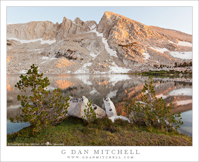
Sheep Peak, McCabe Lakes Basin, Sunset

Sheep Peak, McCabe Lakes Basin, Sunset. Yosemite National Park, California. September 18, 2011. © Copyright 2011 G Dan Mitchell – all rights reserved.

The last light of the day touches the top of Sheep Peak in the McCabe Lakes Basin, Yosemite National Park.

This was a beautiful and fun evening! We were camped at the lower lake in this basin for a few days. The routine, roughly speaking goes something like this: Up before dawn and off to photograph some morning subject until the light goes or the energy wears down; back to camp for breakfast; do camp chores and generally hang out and shoot the breeze into the afternoon; dinner sometime around 3:00 or 4:00; then off to whatever locations is on the agenda for the evening shoot; back to camp after dark. On this evening we all were on the same page and we all headed up to this lake, a few hundred feet higher and no more than a mile from our camp.

The walk was steep but mostly pleasant, at least as long as one went relatively slowly and stayed out of the creek with its willow thickets and instead found a route through the forest nearby. Eventually the route – there is no trail – began to level out at a meadowy area below the lake. This was gave a false sense that the climb was over, but at least the walk up the meadow was very enjoyable, as the small outlet stream twisted through grassy meadow and past the occasional boulder and some trees, with the higher peaks visible above. At the upper end of this meadow was the lake’s basin, with a tall peak on top of the headwall at the upper end, forest beyond the shoreline meadows to the left, and rugged talus slopes and rocky peaks along the right shoreline.

Here we split up and looked for our own shots. As I sometimes do, I found “the spot” and more or less worked it until the light went away. I walked along the thin shoreline meadow, resisting the temptation to just set up and start shooting, and eventually came to this little group of shoreline rocks and trees that I could use as the close element of photographs of the lake and the peaks beyond as the day came to an end.

G Dan Mitchell Photography
About | Flickr | Twitter | Facebook | Google+ | 500px.com | LinkedIn | Email

Text, photographs, and other media are © Copyright G Dan Mitchell (or others when indicated) and are not in the public domain and may not be used on websites, blogs, or in other media without advance permission from G Dan Mitchell.

(Basic EXIF data may be available by “mousing over” large images in posts when this page is viewed on the web. Leave a comment if you want to know more.)