
Tag Archives: stock

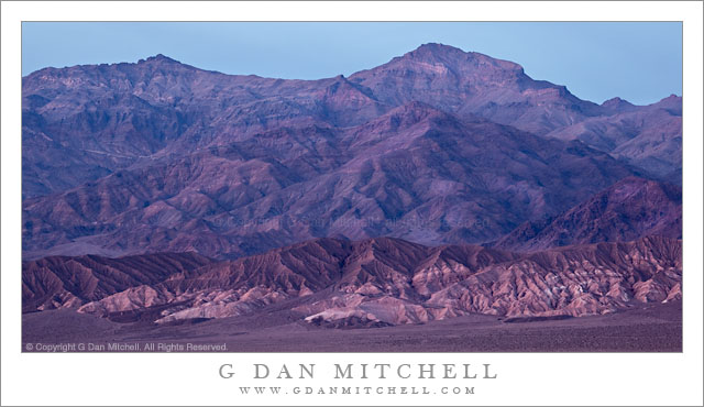
Post-Sunset Glow, Amargosa Range

Post-Sunset Glow, Amargosa Range

Post-Sunset Glow, Amargosa Range. Death Valley National Park, California. March 29, 2011. © Copyright G Dan Mitchell – all rights reserved.

Post-sunset light from bright red clouds casts a reddish glow on the Amargosa Range, Death Valley Buttes, and the Kit Fox Hills.

I think this might be the second in what I could call the “impossible color” series from my late-March trip to Death Valley. (The previous image was a photograph of a wash/alluvial fan at the base of Tucki Mountain, photographed on the same evening.) The lurid and unreal colors are not the result of post-processing gone horribly wrong – the light was actually this color for a short period. The sun had already gone down behind the Cottonwood Mountains to the west of my shooting location in the middle of Death Valley not far from Stovepipe Wells. It had been an interesting sunset with the usual increase in warm colors and some attractive clouds in the sky.

What happened next was something that is probably familiar to those who have done a lot of landscape photography, though they recognize that it is not something that you can quite predict. After the sun had set and dusk was coming on, some final light from far to the west, where the sun had probably already dropped just below the horizon, began to strike high clouds above Death Valley. (I could sort of see this coming, since I had noticed increasing color in the sky further to the east.) As this happened, these clouds began to glow with an intense red color that was mixed with the normal bluish tones of dusk light and surface features took on this purple/red glow for just a brief moment before the light faded.

(Those who look very carefully may notice that the sky above and to the east of the mountains is a lot bluer than the mountains themselves. The color had already left the sky to the east, and at this point was coming from the sky directly overhead and to my west.)

I’m still trying to sort out the complex geology of this area and the ways that features are named. The larger range containing these peaks is called the Amargosa Range, though it encompasses many smaller named sub-ranges – I think these might be part of the Grapevine Mountains, roughly in the neighborhood of Thimble and Corkscrew Peaks. A dark peak in front of the main range at the very far right may be part of Death Valley Buttes, and the banded foreground hills are sometimes called the “Kit Fox Hills.”

G Dan Mitchell Photography | Flickr | Twitter | Facebook |
LinkedIn | Email
Text, photographs, and other media are © Copyright G Dan Mitchell (or others when indicated) and are not in the public domain and may not be used on websites, blogs, or in other media without advance permission from G Dan Mitchell.
Construction Lift, Building Interior

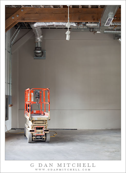
Construction Lift, Building Interior

Construction Lift, Building Interior. San Francisco, California. July 12, 2010. © Copyright G Dan Mitchell – all rights reserved.

I suppose that posting this photograph is the web site equivalent of switching channels – this might be a bit jarring after weeks of Death Valley and other landscape/nature subjects.

I did not quite complete my end-of-year task of going through all of last year’s raw files back in December, so I have been returning to the task bit by bit over the past few weeks. I’m currently working with some photographs from San Francisco, made back in July 2010 when I did some street photography. In old-school style I stuck a 50mm prime on my full frame DSLR and headed out.

At one point I was exploring some waterfront areas of The City and poking my nose into windows of some buildings that were undergoing renovations. Among a few other scenes from this location, I found this one featuring… wait for it!… a piece of construction equipment, posing fetchingly in front of some nice, diffused light coming in from a window out of the frame to the left. I’m still not quite sure why, but I like this image. (Is it perhaps the R2D2-like quality of the orange lift?)

G Dan Mitchell Photography | Flickr | Twitter (follow me) | Facebook (“Like” my page) | LinkedIn | Email
Text, photographs, and other media are © Copyright G Dan Mitchell (or others when indicated) and are not in the public domain and may not be used on websites, blogs, or in other media without advance permission from G Dan Mitchell.
Dunes, Mesquite Flat, Sunrise

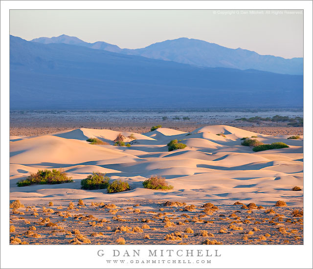
Dunes, Mesquite Flat, Sunrise
Mesquite Flat Dunes, Sunrise

Dunes, Mesquite Flat, Sunrise. Death Valley National Park, California. March 31, 2011. © Copyright G Dan Mitchell – all rights reserved.

Early morning light striking minor dunes on Mesquite Flat with Cottonwood Mountains wash and the Last Chance Range in the distance, Death Valley National Park.

These dunes are not too far from the main Mesquite Dunes near Stovepipe Wells – they are a bit further east from the better known tallest section of the dunes. The areas of lower dunes provide some very interesting shapes and textures on a smaller scale in some ways that those of the larger dunes. I photographed these with a long lens, shooting from a rise, at a point in time very shortly after the first morning light had struck the sand. The background hills, part of a very large alluvial fan at the base of the Cottonwood Mountains, were in the shadow of a cloud.

G Dan Mitchell Photography | Flickr | Twitter (follow me) | Facebook (“Like” my page) | LinkedIn | Email
Text, photographs, and other media are © Copyright G Dan Mitchell (or others when indicated) and are not in the public domain and may not be used on websites, blogs, or in other media without advance permission from G Dan Mitchell.

Manly Beacon, First Light

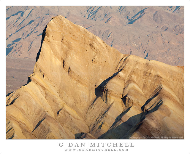
Manly Beacon, First Light

Manly Beacon, First Light. Death Valley National Park, California. March 30, 2011. © Copyright G Dan Mitchell – all rights reserved.

The first morning light strikes Manly Beacon at Zabriskie Point, Death Valley National Park.

Icon alert!

I had more or less promised myself that I would not photograph at Zabriskie Point on this trip – been there, done that – unless the conditions were really special. But I miscalculated my morning start on this day and discovered that I wasn’t going to make it to my intended destination in time. As I passed Zabriskie on my way to the “other place,” telling myself that I still had a half hour before I needed to be in place for the early light… I noticed that clouds above this area were already starting to pick up the pink color of dawn light. I hesitated for a moment – I really wanted to photograph that other subject – but quickly realized that it would make a lot more sense to the shoot the subject that was here in the light that was developing than to drive further and miss out entirely on the first light.

So I turned into that familiar parking lot with its familiar fleet of photographers’ cars and quickly loaded up my gear. I was a bit surprised that I saw so few people up above at the official overlook, but it was quite windy and I figured that perhaps they had just dropped down on the other side of the wall below this spot. In any case, I had a different spot in mind, one further to the right, so I headed over that way and quickly discovered that the wind was blowing almost too strongly to make photographs. I made a couple of shots from a small gap there and then headed up toward the overlook. At the top of the little trail from the parking lot I dropped onto the small use trail to the side of the wall and was again surprised to see almost no other photographers. I walked a few feet farther and discovered that the “usual crowd” was huddled in a small area in the lee of the wall, trying desperately to find protection from the wind.

These days, my main project when I stop at Zabriskie is to find and photograph small, isolated elements of the landscape with a long lens. For the most part – unless truly magical conditions are present, and they weren’t on this morning – I don’t really spend much time on the classic views of Gower Gulch, the Valley, and the Panamint Range. However, since I’m there and know the progression of the light fairly well at this point, I’m not about to pass up the opportunity to get a better image of one of these iconic subjects. So as the first light was about to hit the summit of Manly Beacon I turned my rig that direction and spent a couple of minutes photographing it as the line between shadow and morning light traveled down its face.

G Dan Mitchell Photography | Flickr | Twitter (follow me) | Facebook (“Like” my page) | LinkedIn | Email
Text, photographs, and other media are © Copyright G Dan Mitchell (or others when indicated) and are not in the public domain and may not be used on websites, blogs, or in other media without advance permission from G Dan Mitchell.