Evening fog obscures the view of the Big Sur coastline near Rocky Point.
This photograph was made on my birthday, believe it or not! We had headed down to the Monterey area for dinner, and had a few extra hours in the late afternoon, so we decided to take a quick jaunt down the coast towards the Rocky Point and (almost) Bixby Bridge area. Of course, a little thing like a birthday celebration isn’t going to make me leave my camera gear at home, so this was a fine excuse to do a little photography along the coast highway.
The light was variable and challenging, largely because it was late in the day and the fog bank was moving right up against the coast. While in a few places it pulled back enough to allow a bit of diffused light to land on the coastal bluffs, beaches, and even the water, in most places the fog line was just a bit inland. As we drove south we were mostly in fog, but occasionally as we passed a bit further from the shoreline to follow the contours of a creek drainage or a bay we found a bit of sun. We finally stopped at this high overlook that provides a view back toward Rocky Point, the peninsula at the upper part of the frame, and I made a few exposures.
G Dan Mitchell is a California photographer whose subjects include the Pacific coast, redwood forests, central California oak/grasslands, the Sierra Nevada, California deserts, urban landscapes, night photography, and more. Blog | About | Flickr | Twitter | Facebook | Google+ | 500px.com | LinkedIn | Email
Evening fog comes in as the rugged Big Sur coast stretches north from near Soberanes Point, California.
Talk about photographic geekiness – we ended up making photographs on my birthday! Because of a variety of factors, this turned out to be a bit of a low key birthday this year – despite some earlier plans to do all sorts of wild and crazy things. (Completing the JMT or going to Alaska will perhaps wait a bit… ;-) After a quiet and lazy morning we decided to head down to the Monterey area for a birthday dinner, which turned out to be quite nice by the way. (Thanks, Patty!)
Since we arrived a few hours before our dinner reservation. After stalling around a bit, thinking about this and that option, we decided to do the usual, obvious thing and head south on the Highway 1, the “coast highway,” into the upper portion of the Big Sur coastline area. While it is a very familiar area and one I visit a lot, it is never the same twice – all of the variables of light and atmosphere and season and weather are in play and you almost never know quite what you’ll find. On this early evening, the most important factor was that the edge of the ocean fog was positioned very close to the shore. This meant that sometimes it extended just a bit inland, creating light that ranged from slightly luminous to gray and murky, while in other areas it was just offshore, allowing light to hit the coast and even to light the surface of the ocean a bit. Here at the cove where the creek comes down Soberanes Canyon to meet the ocean, we found one of those boundaries – quite gray along the immediate coast in the distance, sunlight on the bluffs and hills at the right, and that wonderful boundary light in between. And above that, the barely perceptible difference between the soft clouds of fog and the light blue of the late-day sky.
G Dan Mitchell is a California photographer whose subjects include the Pacific coast, redwood forests, central California oak/grasslands, the Sierra Nevada, California deserts, urban landscapes, night photography, and more. Blog | About | Flickr | Twitter | Facebook | Google+ | 500px.com | LinkedIn | Email
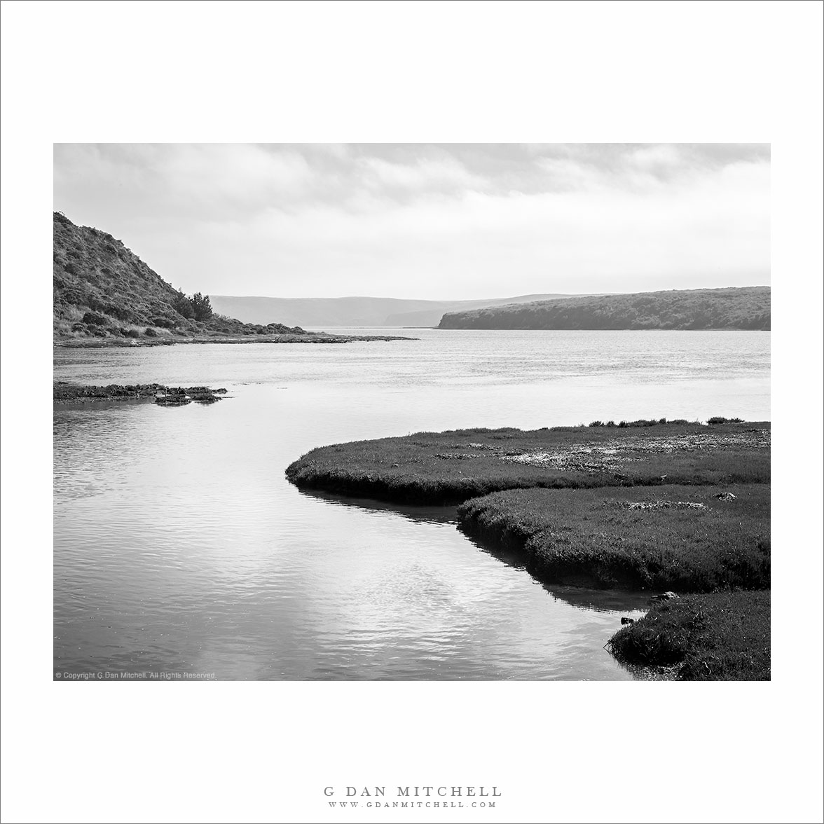
“Home Bay, Drakes Estero” — Fog rolls in over Drakes Estero beyond Home Bay, Point Reyes National Seashore
This quick late-July visit to Point Reyes was an opportunity to re-learn a few lessons about going out to make photographs. I drove up to San Francisco, where my wife was to be involved in a music performance — the plan being to drop her off and then drive on over the Golden Gate Bridge to Point Reyes. It is often cold and windy there, even in the summer, but this was a very warm period and it looked like the coast might be clear of fog. With this in mind, I planned to either visit the Limantour Beach or else hike out towards Drakes Bay.
I should have sensed that things were about to evolve in ways that I had not planned for when, during a brief stop at the Point Reyes visitor center, the rangers announced that the road to Limantour was closed since a fire had just started in the area! With that option gone, I figured that Drakes Bay would be my objective, and I had images of afternoon and evening light on this day of little or no fog. I drove on out to the Estero trailhead where it was, in fact, quite sunny, though a bit windy. I loaded up my camera pack with a few lenses and a tripod, and set out towards Drakes Head, thinking I might make it there for late afternoon light. Soon I saw the telltale puffs of incoming fog overhead, and I came around a bend in the trail to see that the fog had already moved in to the west and over Drakes Bay. Fortunately, iin most cases I would rather photograph in “interesting” weather than in supposed perfect blue sky weather.
At a point where the trail descended to cross a dike at the head of Home Bay, I saw this conjunction of near and far forms, with the distant bluffs under the incoming fog, so I stopped to make a few photographs before moving on. To make a potentially long story a bit shorter, the temperature quickly dropped and the wind picked up to levels that made photography increasingly difficult. I managed to work with one other scene that included a curving snag in front of the bay, but it was already becoming difficult to find a calm moment in the wind to click the shutter. I kept going, finally reaching the trail junction that heads off towards Drakes Head, only to realize that I would never get all the way out there in time to return before dark. Cutting the hike short after a bit more than an hour and a half of hiking, I began to retrace my steps back to the trailhead.
In the end, this is really the only photograph that I came away with – despite carrying that fully loaded camera pack out and back! But this reminded me of a first lesson, namely that it is worth the effort even if I only come back with a single shot that I like. This one, to me, evokes the relative isolation and quiet of this spot in the upper reaches of the calm waters of Drakes Bay, with the fog bank beginning to assemble across the distant bluffs. A second lesson is that sometimes on a photographic quest, it is OK to simply enjoy the surroundings. A practical photographer can remind himself or herself that scouting is a good thing, and that things not photographed this time may well be on a future visit. And a long-time hiker can – and did – remind himself that sometimes it is just fine to leave the camera in the pack and just enjoy the wind and the space.
Sea stacks dot the rugged Big Sur coastline at Rocky Point in evening light.
Continuing with the theme of evening light on the Big Sur coastline, I made this photograph along a favorite section of this portion of the California coast not long before sunset. (I left enough time after photographing this scene to drive back up the coast to more or less the small road-cut just visible in the upper right corner of the frame, from which I made another photograph shooting back into a large cove that is out of the range of this photograph to the right.) At this time, perhaps a half hour or so before sunset, the color of the light was warming and intensifying but had not yet reached that obviously red stage that comes right at and right after actual sunset.
The peninsula in the upper part of the photograph is known as Rocky Point and, among other things, is a spot many may know because of a restaurant perched there above these stunning views of the Pacific coast. (I hear it is pricey!) My camera position was at a pull-out along the Pacific Coast Highway at a spot where the road rises to pass around another bit of land that extends to the west, and this high camera position let me aim the camera down to minimize the sky and fill the frame with the ocean, the rocky sea stacks and cliffs, and the “point” itself. With the main variable being the unpredictable patterns in the surf, I made a series of exposures at what I thought might be likely moments and then selected from among them in post. I like the series of diagonal lines in the foreground surf and the way the low sun picks off the tops of the waves.
G Dan Mitchell is a California photographer whose subjects include the Pacific coast, redwood forests, central California oak/grasslands, the Sierra Nevada, California deserts, urban landscapes, night photography, and more. Blog | About | Flickr | Twitter | Facebook | Google+ | 500px.com | LinkedIn | Email
Photographer and visual opportunist. Daily photos since 2005, plus articles, reviews, news, and ideas.
Manage Consent
To provide the best experiences, we use technologies like cookies to store and/or access device information. Consenting to these technologies will allow us to process data such as browsing behavior or unique IDs on this site. Not consenting or withdrawing consent, may adversely affect certain features and functions.
Functional
Always active
The technical storage or access is strictly necessary for the legitimate purpose of enabling the use of a specific service explicitly requested by the subscriber or user, or for the sole purpose of carrying out the transmission of a communication over an electronic communications network.
Preferences
The technical storage or access is necessary for the legitimate purpose of storing preferences that are not requested by the subscriber or user.
Statistics
The technical storage or access that is used exclusively for statistical purposes.The technical storage or access that is used exclusively for anonymous statistical purposes. Without a subpoena, voluntary compliance on the part of your Internet Service Provider, or additional records from a third party, information stored or retrieved for this purpose alone cannot usually be used to identify you.
Marketing
The technical storage or access is required to create user profiles to send advertising, or to track the user on a website or across several websites for similar marketing purposes.


 G Dan Mitchell is a California photographer whose subjects include the Pacific coast, redwood forests, central California oak/grasslands, the Sierra Nevada, California deserts, urban landscapes, night photography, and more.