Tag Archives: glow

Fog, Surf, and Rocks

Fog, Surf, and Rocks - Midday sun glows through coastal fog bank above offshore rocks and surf, Point Lobos State Reserve.
Midday sun glows through coastal fog bank above offshore rocks and surf, Point Lobos State Reserve.

Fog, Surf, and Rocks. Point Lobos State Reserve, California. March 29, 2012. © Copyright 2012 G Dan Mitchell – all rights reserved.

Midday sun glows through coastal fog bank above offshore rocks and surf, Point Lobos State Reserve.

I made a new photograph in the “barely there” series today at Point Lobos. It was a surprisingly good photography day at Point Lobos. I say this because when I started out this morning things did not look very promising at all. At my home, it was cloudy and gray – but since at least one weather forecast mentioned sun down in the Monterey Peninsula area, I decided to give it a try. As I drove south it got worse – I ended up in very thick fog during the first 30 minutes or so of my drive. However, recalling that when there is inland fog this time of year there is often clearing at the coast, I decided to keep going. A few miles from Monterey the skies began to clear, leaving some pockets of fog here and there with high thin clouds above. Now things were looking up! High, thin clouds can provide excellent conditions for many kinds of landscape shooting, since these conditions soften that shadows and take the harsh edge off of the light.

Arriving at Point Lobos I could see there was fog a good distance off shore, but beautiful light was shining through the forest along the entrance road. I headed down to Whalers Cove and went for a hike around the far side of the cove, and ended up spending the better part of three hours poking around in this area. By the time I got back to my car it was lunch time, and I decided to at least head out to the west-facing shoreline to look around before leaving. When I got there, the offshore fog bank had moved in and was starting to flow across the shoreline. A bit further south I could see the backlit fog lit brilliantly by the sun and almost obscuring the rocks and islands in the Bird Island area. In fact, by the time I got my camera on the tripod, these islands had completely disappeared. I waited a bit, and their shapes began to again barely emerge from the fog.

G Dan Mitchell is a California photographer whose subjects include the Pacific coast, redwood forests, central California oak/grasslands, the Sierra Nevada, California deserts, urban landscapes, night photography, and more.
Blog | About | Flickr | Twitter | FacebookGoogle+ | 500px.com | LinkedIn | Email

Text, photographs, and other media are © Copyright G Dan Mitchell (or others when indicated) and are not in the public domain and may not be used on websites, blogs, or in other media without advance permission from G Dan Mitchell.

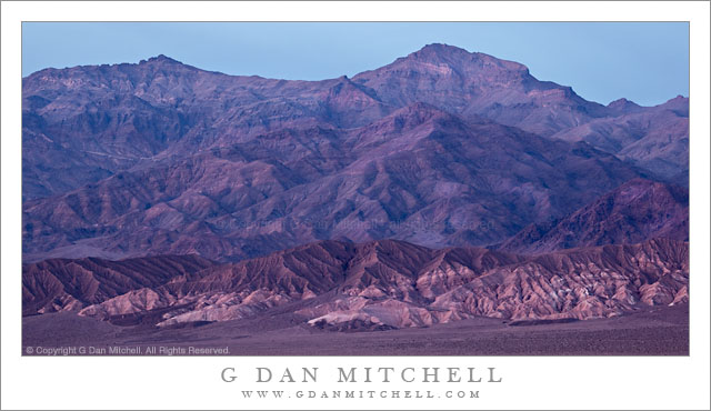
First Light on Zabriskie Point Hills

First Light on Zabriskie Point Hills

First Light on Zabriskie Point Hills. Death Valley National Park, California. April 3, 2009. © Copyright 2009 G Dan Mitchell – all rights reserved.

The first morning light touches hills at Zabriskie Point with ridges of the Panamint Range visible in the distance, Death Valley National Park, California.

When I visit Death Valley – typically, at least once each year – I usually try to seek out some of the less iconic scenes. However, I still do visit the icons, too. And Zabriskie Point at dawn may be the best known and perhaps the most photographed “icon” in the park. When I do go to Zabriskie it is usually for one of two reasons. First, if the light or conditions are truly special, I’ll be there with everyone else when the sun comes up! Second, I have a vague project to try to photograph aspects of Zabriskie that are different from the icon views across Gower Gulch or of Manley Beacon. This photographs sort of fits into that second category.

Those who have photographed here more than once become acquainted with the way that the morning light typically unfolds at Zabriskie. The pre-dawn light begins to softly light the entire scene, and before long the very first dawn light strikes the highest ridges of the Panamint Range on the opposite side of the Valley to the west. This light works its way down the face of that range, gradually illuminating the ridges and valleys of the range and spreading horizontally. It then begins to hit the Valley floor and works its way east and closer to Zabriskie and the rest of the ranges along the east side of the Valley. Although the closest hills are in shadow, one can almost sense the beams of light over head that are reaching into the Valley and sense that the angle of this light is gradually working down toward the closest ridges. Then the first light appears on the higher features around Zabriskie Point, at first soft but quickly increasing in intensity.

This photograph was made at this moment when that firs light arrives. The subject is a darker and rugged ridge that rises between the usual vantage points and the backdrop of the distant Panamint range, which in this photograph is somewhat obscured by the hazy atmosphere on a day when giant dust storms were just beginning to develop further north in the Valley.

G Dan Mitchell is a California photographer whose subjects include the Pacific coast, redwood forests, central California oak/grasslands, the Sierra Nevada, California deserts, urban landscapes, night photography, and more.
Blog | About | Flickr | Twitter | Facebook | Google+ | 500px.com | LinkedIn | Email

Text, photographs, and other media are © Copyright G Dan Mitchell (or others when indicated) and are not in the public domain and may not be used on websites, blogs, or in other media without advance permission from G Dan Mitchell.

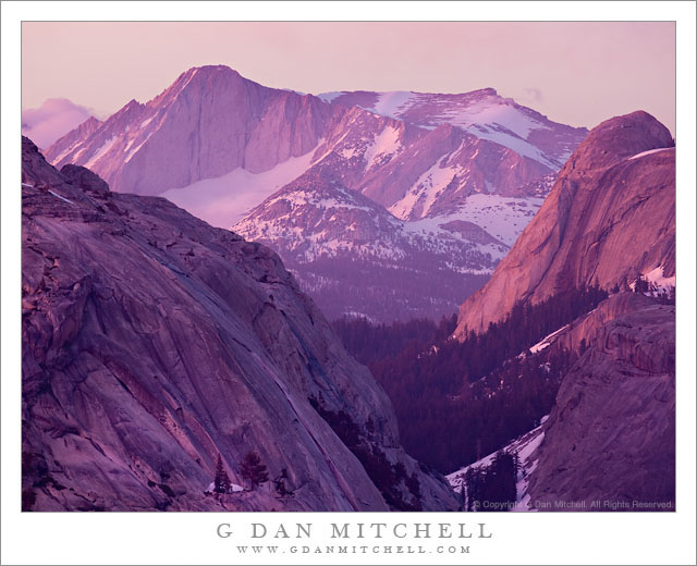
Alpenglow, Mount Conness

Alpenglow, Mount Conness

Alpenglow, Mount Conness. Yosemite National Park, California. June 18, 2011. © Copyright G Dan Mitchell – all rights reserved.

The last evening light illuminates domes near Tenaya Lake and the summit of Mount Conness with briilliantly colorful alpenglow, Yosemite National Park.

The tall peak at upper left is the summit of Mount Conness, one of the highest peaks in Yosemite National Park. The peak is located on the park boundary and the Sierra Nevada crest a bit north of Tioga Pass, and is visible from many places in the Tuolumne/Tioga high country. It is also a popular destination for peak baggers. The left foreground granite dome is the lower face of Polly Dome, which drops to the shoreline of Tenaya Lake. The left slope of Pywiak dome is visible in the shadows at lower right and beyond is the more brightly illuminated Medlicott dome.

I forgive you if you don’t believe the colors that you see in this photograph. I barely believe them myself, and I was (obviously!) there for the show. What happened on this evening was a near perfect example of a light phenomenon that Sierra photographers watch for and are occasionally lucky enough to experience. I have learned to see the signs that indicate that this light is possible, but also to understand that even when the conditions offer this potential that they rarely deliver.

On certain cloudy evenings in the Sierra it appears that there will be no sunset color – everything is hazy and drab and washed out. But if things play out just right, this very set of drab conditions (that induce some photographers to put away their gear too soon!) can produce some of the most striking and intense color possible if a few things fall into place just right. On this evening I had stopped for a moment at Olmsted Point, thinking to photograph ice-covered Tenaya Lake with a long lens and including the mass of Mount Conness in the distance. When I arrived there, things were about as unpromising as they could possibly be. A dull, greenish-blue haze hung in the air, overcast washed out the light, and Conness was obscured by clouds. I had actually put my gear back in the car when I looked back up and noticed that the summit of Conness had briefly poked through the clouds, accentuating its bulk and the sense that it towered over the foreground mountains. The light was still awful (I have the photos to prove it! ;-) but I thought I’d see if I could get something with the peak emerging from its shroud.

But still nothing much happened. I turned the camera to photograph some nearby trees and a blackbird that was looking for snacks. Then I noticed that there was some brighter light to the southwest and I began to consider the possibility that the cloud cover might end a bit to the west – and that is requirement #1 for the light conditions I’m describing. If the cloud deck ends to the west, as the sun reaches the horizon it may briefly break under the clouds and send brilliantly colorful light up into the clouds in the Sierra from below, creating a miles-wide light panel of the most astonishing colors. But still, it was hazy and the peaks were shrouded in clouds. But then I noticed that the clouds around Conness were beginning to drift off to the east and thin a bit. I mentioned (knock on wood!) to one of the other photographers that there was a possibility of “miracle light,” but that I wasn’t making any promises!

Then the thinning clouds began to pick up a slight pink tinge and the left side of Conness began to get some light directly from the west. Then, within a minute or so, the colors went absolutely crazy. People around me were audibly gasping as the color changed. At one point several of us spontaneously looked up to the west when we noticed the light suddenly increase out of the corners of our eyes. At the same time, the clouds almost completely dissipated from the area around the peak and because the whole sky was filled with brilliantly colorful clouds, this light began to suffuse even the depths of the canyon and slopes facing away from the sunset with this amazing light.

Never put your camera away until the last light is gone. :-)

G Dan Mitchell Photography | Flickr | Twitter (follow me) | Facebook (“Like” my page) | LinkedIn | Email
Text, photographs, and other media are © Copyright G Dan Mitchell (or others when indicated) and are not in the public domain and may not be used on websites, blogs, or in other media without advance permission from G Dan Mitchell.
Post-Sunset Glow, Amargosa Range

Post-Sunset Glow, Amargosa Range

Post-Sunset Glow, Amargosa Range. Death Valley National Park, California. March 29, 2011. © Copyright G Dan Mitchell – all rights reserved.

Post-sunset light from bright red clouds casts a reddish glow on the Amargosa Range, Death Valley Buttes, and the Kit Fox Hills.

I think this might be the second in what I could call the “impossible color” series from my late-March trip to Death Valley. (The previous image was a photograph of a wash/alluvial fan at the base of Tucki Mountain, photographed on the same evening.) The lurid and unreal colors are not the result of post-processing gone horribly wrong – the light was actually this color for a short period. The sun had already gone down behind the Cottonwood Mountains to the west of my shooting location in the middle of Death Valley not far from Stovepipe Wells. It had been an interesting sunset with the usual increase in warm colors and some attractive clouds in the sky.

What happened next was something that is probably familiar to those who have done a lot of landscape photography, though they recognize that it is not something that you can quite predict. After the sun had set and dusk was coming on, some final light from far to the west, where the sun had probably already dropped just below the horizon, began to strike high clouds above Death Valley. (I could sort of see this coming, since I had noticed increasing color in the sky further to the east.) As this happened, these clouds began to glow with an intense red color that was mixed with the normal bluish tones of dusk light and surface features took on this purple/red glow for just a brief moment before the light faded.

(Those who look very carefully may notice that the sky above and to the east of the mountains is a lot bluer than the mountains themselves. The color had already left the sky to the east, and at this point was coming from the sky directly overhead and to my west.)

I’m still trying to sort out the complex geology of this area and the ways that features are named. The larger range containing these peaks is called the Amargosa Range, though it encompasses many smaller named sub-ranges – I think these might be part of the Grapevine Mountains, roughly in the neighborhood of Thimble and Corkscrew Peaks. A dark peak in front of the main range at the very far right may be part of Death Valley Buttes, and the banded foreground hills are sometimes called the “Kit Fox Hills.”

G Dan Mitchell Photography | Flickr | Twitter | Facebook |
LinkedIn | Email
Text, photographs, and other media are © Copyright G Dan Mitchell (or others when indicated) and are not in the public domain and may not be used on websites, blogs, or in other media without advance permission from G Dan Mitchell.