Tag Archives: mount

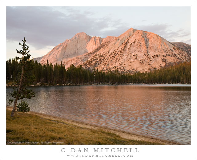
Mount Conness and Lower Young Lake, Sunset

Mount Conness and Lower Young Lake, Sunset

Mount Conness and Lower Young Lake, Sunset. Yosemite National Park, California. September 11, 2007. © Copyright G Dan Mitchell – all rights reserved.

Alpenglow lights Mount Conness above Lower Young Lake in the Yosemite National Park back-country.

I was recently going through a large portion of my archive in search of a variety of photographs of Mount Conness, a well-known peak along the northeast edge of Yosemite National Park on the crest of the Sierra. This is perhaps not the best known peak in Yosemite for most people – they are obviously going to be far more familiar with the cliffs and domes around Yosemite Valley or with Mount Lyell (the tallest peak in the park) or perhaps Mount Dana (second highest peak, and towering above the Tioga Pass entrance.) Mount Conness is found a bit further “north” along the crest, and while it may be less known, it is certainly no less visible once you know where to look. You can see it in the distance towering above Tenaya Lake if you stop at the iconic Olmsted Point overlook. It is visible from many places along the road to Tuolumne Meadows. Once you get away from roads and into the high country it can be seen from almost any high point with an open view in the direction of the peak, including places like Vogelsang High Sierra Camp.

This photograph was made on a quiet late-season evening at Lower Young Lake, a place that I return to frequently, most of the time in the off-season when fewer people are there and the fall colors of the high country are starting to appear. The peak (and many other features in this area) are beautifully illuminated late in the day as this high ridge is open without obstruction to the west. The light on the peak was magical on this evening, being colorful and contrasting with the higher and more drab clouds, but not being as gaudily bright as it can be on other evenings.

G Dan Mitchell Photography | Flickr | Twitter (follow me) | Facebook (“Like” my page) | LinkedIn | Email
Text, photographs, and other media are © Copyright G Dan Mitchell (or others when indicated) and are not in the public domain and may not be used on websites, blogs, or in other media without advance permission from G Dan Mitchell.

‘Rim of the World’ Overlook, Morning

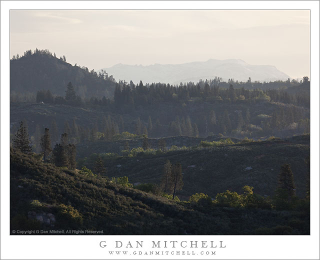
'Rim of the World' Overlook, Morning

‘Rim of the World’ Overlook, Morning. Sierra Nevada, California. May 7, 2011. © Copyright G Dan Mitchell – all rights reserved.

The view toward Yosemite and the High Sierra from the ‘Rim of the World’ overlook above the Tuolumne River canyon along highway 120.

‘Rim of the World’ is the name given to a scenic overlook above the deep valley of the Tuolumne River along route 120, the northern route into Yosemite National Park. It is something of an odd place. It is a fairly pedestrian traffic pullout, though it overlooks the immense and impressively deep canyon of the Tuolumne. But the view is at least partially obstructed by things like power lines. However, it is a view that on clear days can extend great distances to very high Sierra peaks.

I most often simply blow past the spot on my way to or from the park. However, on this morning as I passed I thought the low morning light looked interesting so I found a spot to turn around and drove back. There was a bit of high cloudiness, and the light was coming across the folds of these foreground hills from the right, lighting up various bits of ridge and trees and illuminating the morning haze enough to amplify the effect of distance. If I’m not mistaken, the further ridge with its faintly seen snow fields is in the area of Mount Hoffman.

G Dan Mitchell Photography | Flickr | Twitter (follow me) | Facebook (“Like” my page) | LinkedIn | Email
Text, photographs, and other media are © Copyright G Dan Mitchell (or others when indicated) and are not in the public domain and may not be used on websites, blogs, or in other media without advance permission from G Dan Mitchell.
Richardson Bay, Morning

Richardson Bay, Morning
Richardson Bay

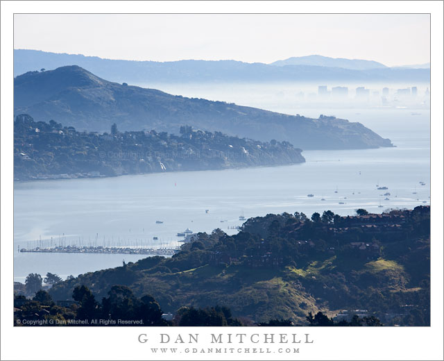
Richardson Bay, Morning. San Francisco Bay Area, California. February 12, 2011. © Copyright G Dan Mitchell – all rights reserved.

Photograph of Richardson Bay from Marin hills, showing Tiburon Peninsula, Angel Island, downtown Oakland, East Bay Hills, and Mount Diablo in the distance.

This photograph was shot from essentially the same position as the previous one, a black and white photo of the same vista, though with shorter focal length. I used a longer focal length here to try to enlarge to closer elements and leave out some of the stuff along the edges, and to minimize the amount of sky to some extent. I liked the color version of this – it was hard for me to think about giving up the nice overall blue haze, but even more to give up the was of light on some of the green grassy areas at the bottom of the frame.

There is quite a bit of stuff in this image, so let me describe what you see. At the bottom of the frame are hills above Marin City. Beyond the foreground hills you see Richardson Bay, which is an arm of San Francisco Bay near the entrance to Golden Gate. Across the bay we see the hills of the Tiburon Peninsula and beyond that looms the peak of Angel Island. In the distance and across San Francisco the buildings of downtown Oakland are visible through the low level backlit morning haze. Beyond are the East Bay Hills and the furthest peak is Mount Diablo, all the way out past Concord.

G Dan Mitchell Photography | Flickr | Twitter | Facebook | Email
Text, photographs, and other media are © Copyright G Dan Mitchell (or others when indicated) and are not in the public domain and may not be used on websites, blogs, or in other media without advance permission from G Dan Mitchell.
Canon EOS 5D Mark II (at B&H)

McGee Canyon and Mount Morgan

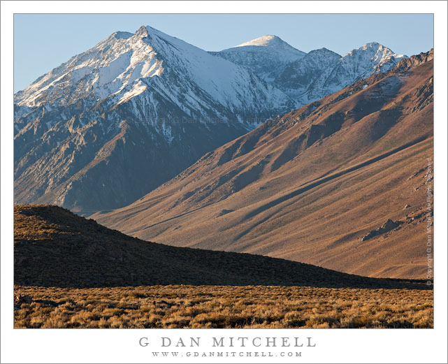
McGee Canyon and Mount Morgan

McGee Canyon and Mount Morgan. Owens Valley, California. October 10, 2010. © Copyright G Dan Mitchell – all rights reserved.

Snow crested Mount Morgan rises above McGee Canyon and the sagebrush-covered hills of Owens Valley in the eastern Sierra Nevada.

I’ve been traveling to the Sierra for many years. My first recollection of the range is a faint mental image of a shoreline park at Lake Tahoe when my family moved to California – I was four years old. My next memory is of staying at a small motel in El Portal next to the high water of the Merced River back in the days before the current mega-hotels were erected. One thing that all of my early Sierra experiences had in common is that I always approached the range from the west since I lived (and still live) in the San Francisco Bay Area. For the person whose orientation to the range is from the west, the Sierras are a range that begins almost imperceptibly in the Central Valley. Although you can see distant peaks from the Valley on clear days, it is hard to say where the range begins. As you head east you encounter some very small and rounded hills which gradually get larger. Eventually you are going up more than up and down as you  travel through oak and grass lands. At some point the road rises into forest, but the mountain tops are mostly rounded and forest covered. Keep going and a few rocky prominences begin to appear along the ridges and some distant granite peaks become visible. Only after a lot of driving do you find yourself in the higher reaches of the range, and this only in the few areas where roads cross from west to east. In most places you cannot even see the summit of the range close up from the west without walking a long ways.

It was only many years later that I first went over the summit of the range and saw it from the east side. The Sierra is (are?) completely different when approached this way. Instead of a long, gradual, and relatively gentle rise to high valleys and forests and meadows, the eastern escarpment of the Sierra rises abruptly – one might say violently – and directly, in most places, from the high desert sagebrush country of Owens Valley and similar places. This wall of peaks seems almost inaccessible, and I imagine that many people who only drive past on highway 395 must regard it that way.

This photograph was made from a spot just a mile or two east of highway 395, out an a gravel road that I know. I have photographed this shadowed foreground ridge and the peaks beyond in the past, so I had a fairly good idea of what I would find at this location before I made the photograph on an early October morning when fall storms had dusted the highest peaks with snow. I used a somewhat long lens and tight framing to emphasize the rise from the foreground desert to the very high peaks beyond.

This photograph is not in the public domain and may not be used on websites, blogs, or in other media without advance permission from G Dan Mitchell.
G Dan Mitchell Photography
Flickr | Twitter | Facebook Fan Page | Facebook | Friendfeed | Email