
Tag Archives: rock

Evening Clouds and Rocks, Point Lobos

Evening Clouds and Rocks, Point Lobos

Evening Clouds and Rocks, Point Lobos. Point Lobos State Reserve, California. January 8, 2011. © Copyright G Dan Mitchell – all rights reserved.

Evening clouds over the Pacific Ocean and offshore rocks at Point Lobos State Reserve.

It always strikes me as odd that at the most beautiful time of day at Point Lobos, almost all of the park visitors have left. In the evening as the sun goes down over the Pacific and the fog may or may not roll in, there are often only a handful of people left in the park, a good number of them photographers. On this Sunday evening it may have been that some were discouraged by the low clouds that had come in earlier in the afternoon, but sometimes these clouds dissipate or are lit up from behind at sunset – at that is precisely what happened on this evening. The low clouds began to thin and as they did so beams of light came through the breaks in the clouds and painted the surface of the Pacific with patchy light. A bit later, after I made this photograph, the clouds thinned even more and high, pink sunset clouds appeared briefly. And there was not another person anywhere near me to see it.

This photograph is not in the public domain and may not be used on websites, blogs, or in other media without advance permission from G Dan Mitchell.
G Dan Mitchell Photography
Flickr | Twitter (follow me) | Facebook (“Like” my page) | LinkedIn | Email

Text, photographs, and other media are © Copyright G Dan Mitchell (or others when indicated) and are not in the public domain and may not be used on websites, blogs, or in other media without advance permission from G Dan Mitchell.


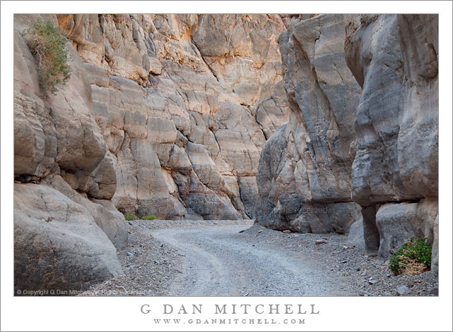
Titus Canyon Road

Titus Canyon Road
Titus Canyon Road

Titus Canyon Road. Death Valley National Park, California. March 28, 2010. © Copyright G Dan Mitchell – all rights reserved.

I made this photograph during midday hours after walking a ways up into the canyon from its mouth – the alternative to making the very long drive over the Grapevine Mountains from Amargosa Valley. (I have done the latter a few times, too.) While most Death Valley subjects tend to be appealing in the early morning or in the evening, many of the canyons can be at their best during the middle of the day, especially the very deep and narrow canyons like lower Titus Canyon. Here the canyon narrows down to the point that there is only room of a single gravel track, and twists and turns around rocky outcroppings. The light striking the upper canyon walls – out of the range of this photograph – reflects down into the canyon and produces soft, diffused illumination.

This photograph is not in the public domain and may not be used on websites, blogs, or in other media without advance permission from G Dan Mitchell.

G Dan Mitchell Photography
About | Flickr | Twitter | Facebook | Google+ | 500px.com | LinkedIn | Email

Text, photographs, and other media are © Copyright G Dan Mitchell (or others when indicated) and are not in the public domain and may not be used on websites, blogs, or in other media without advance permission from G Dan Mitchell.

(Basic EXIF data may be available by “mousing over” large images in posts. Leave a comment if you want to know more.)


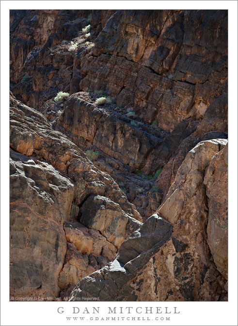
Rugged Terrain, Lower Titus Canyon

Rugged Terrain, Lower Titus Canyon

Rugged Terrain, Lower Titus Canyon. Death Valley National Park, California. March 28, 2010. © Copyright G Dan Mitchell – all rights reserved.

Details of the rugged cliffs and walls rising above lower Titus Canyon in Death Valley National Park.

Titus Canyon Road is one of the marvels of Death Valley National Park. It begins in high desert of Amargosa Valley near the town of Beatty and the ghost town of Rhyolite, winds over the summit of the Grapevine Mountains, drops precipitously into upper Titus Canyon, passes a number of historically interesting sites, passes through a very narrow and deep section in the lower canyon, and then suddenly emerges into the vastness of Death Valley.

In the lower section of the canyon, the wash becomes very narrow, passing through a twisty slot canyon and is, in places, barely wide enough for the one-lane gravel road. Here the walls of the canyon press tightly together and rise steeply for hundreds of feet. Some places are so deep that the sun rarely penetrates to the bottom.

Fortunately for the preservation of the canyon the road is horrible, at least if you are used to more civilized driving. It is a one-way road and the whole thing is gravel. Sections are in decent shape, but it other places the road passes over narrow and twisty sections next to precipitous drop-offs and then dives steeply into deep canyons. At times the route is closed after heavy rains or other conditions that make the route impassable.

Fortunately, the section that is perhaps the most impressive in many ways – the deep slot canyon near the bottom – is easily accessible by foot from Death Valley. After a short drive up to the canyon entrance on a gravel road to a parking area, you can enter the canyon on foot and walk up as far as you want. This photograph was made within the lower mile of the canyon during the late morning, when the light penetrates more deeply into the canyon and creates a glow on the canyon walls.

G Dan Mitchell Photography
About | Flickr | Twitter | Facebook | Google+ | 500px.com | LinkedIn | Email

Text, photographs, and other media are © Copyright G Dan Mitchell (or others when indicated) and are not in the public domain and may not be used on websites, blogs, or in other media without advance permission from G Dan Mitchell.

(Basic EXIF data may be available by “mousing over” large images in posts. Leave a comment if you want to know more.)


Alcatraz Island, San Francisco Bay Fog

Alcatraz Island, San Francisco Bay Fog

Alcatraz Island, San Francisco Bay Fog. San Francisco, California. December 16, 2010. © Copyright G Dan Mitchell – all rights reserved.

Alcatraz Island is almost completely obscured by San Francisco Bay fog drifting beneath blue sky.

This is another of what I sort of think of as my “barely there” photographs, in which I work with subjects that are almost completely obscured by fog, mist, rain, or clouds. Some of my Yosemite Valley photographs from a rainy weekend near the end of this past October are in the same category.


You can experience an astonishing range of atmospheric conditions in and around San Francisco Bay. The patterns at this time of year (the very end of fall, and more like winter conditions) are quite different from summer. As often as not, the fog in the winter comes from inland rather than drifting in through the Golden Gate, and it is more related to the tule fog that can sit in the Central Valley during the winter, sometimes for weeks. On the other hand, after the passage of a winter storm (which brings its own impressive conditions) the winter air over the Bay can be crystal clear. And frequently the conditions can change rapidly, as was the case on this morning. When I arrived in the Marin Headlands above the north end of the Golden Gate Bridge before dawn, I was initially a bit disappointed that the conditions were too clear! Except for a bank of clouds right above San Francisco (the subject of some other recently posted photographs) the rest of the Bay was almost completely clear. But then, at first imperceptibly and then very quickly, fog began to condense out of the air above the bay. In a short period of time subjects that had been clearly visible were completely obscured. Within moments after making this photograph, Alcatraz was not longer visible.

This photograph is not in the public domain and may not be used on websites, blogs, or in other media without advance permission from G Dan Mitchell.

G Dan Mitchell Photography
Flickr | Twitter | Facebook Fan Page | Facebook | Friendfeed | Email