Tag Archives: rocks

Winter Moon, Clouds, and Granite

Winter Moon, Clouds, and Granite

Winter Moon, Clouds, and Granite. Yosemite Valley, California. February 23, 2013. © Copyright 2013 G Dan Mitchell – all rights reserved.

Winter moon rises through post-storm clouds above Yosemite Valley, California

On this winter evening, photographing the “usual subjects” in Yosemite Valley was not easy. This was the weekend of the Horsetail Falls pilgrimage, and hundreds or perhaps thousands of people were lined up with cameras in hopes of making their photograph of this thing/event – but for most this was not to be as the water fall was almost dried up and clouds blocked the sunset light. It had been a cloudy day, starting out with rain and staying that way for a good part of the day, with even a bit of light snow at times. As evening approached it looked like the cloud deck was going to remain thick and low and that it would likely be a gray evening.

With it looking like the potential for inspiring light was quite low, we went to Tunnel View – it seemed as good as any other option, it can be an inspiring place even when it doesn’t provide inspiring photographic opportunities, and I was with someone who had not really tried to photograph there. When we arrived there was some clearing, though the clouds seemed to remain thick to the west, meaning the no brilliant light was likely to be seen. I put a long lens on my camera and worked the upper rim of the Valley to my right, about 90 degrees away from the direction most were shooting, but where fog and mist drifted across the rim, granite pinnacles and cliffs, and among trees. As I watched this I noticed the nearly full moon occasionally poke out from behind clouds above Sentinel Rocks as the clouds and mist drifted this way and that. Since it was that early twilight time when a good exposure for the light of the moon can also work for other subjects such as clouds, sky, and mountains, I swung the camera around and watched the drifting clouds, waiting or moments when the took on interesting shapes and when the moon was visible.

G Dan Mitchell is a California photographer and visual opportunist whose subjects include the Pacific coast, redwood forests, central California oak/grasslands, the Sierra Nevada, California deserts, urban landscapes, night photography, and more.
Blog | About | Flickr | Twitter | FacebookGoogle+ | 500px.com | LinkedIn | Email

Text, photographs, and other media are © Copyright G Dan Mitchell (or others when indicated) and are not in the public domain and may not be used on websites, blogs, or in other media without advance permission from G Dan Mitchell.

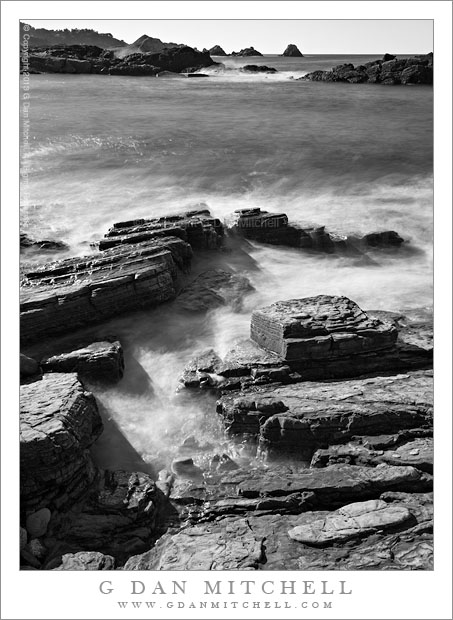
Rocks and Surf, Weston Beach

Rocks and Surf, Weston Beach

Rocks and Surf, Weston Beach. Point Lobos State Reserve, California. January 13, 2013. © Copyright 2013 G Dan Mitchell – all rights reserved.

A long exposure photograph of shoreline rocks and surf at Weston Beach, Point Lobos State Reserve

I had been a while since I had photographed along the California coast south of Monterey, but I finally made it back down there on this mid-January morning, ending up at the Point Lobos State Reserve. This is a location I shoot frequently since it is barely more than an hour from my home, and I’ve gone there since I was a kid. Today was perhaps not the ideal day to photograph there – it was (literally) freezing cold in the morning and then the skies were almost completely clear. Clear skies are not my favorite for photography. I much prefer some fog or clouds. In this photograph I dealt with that by pointing the camera down and placing the horizon very close to the top of the frame.

Arriving at the reserve, I first headed down to the familiar location of Weston Beach. (I still cannot quite figure out which this place is called a “beach” – rocky slabs slope down to the water and the closest thing to sand is a bit of rocky gravel. But I digress…) When I arrived, the early morning sun was almost back-lighting the islands and sea stacks to the south of here, so I walked back up the road a bit to find higher ground to shoot in that direction. While shooting from there I saw that it could be interesting to shoot below this trail and much closer to the water, using a very wide-angle lens and perhaps a 9-stop neutral density filter to extend the exposure. Rather than hoping the fence to get to the likely spot 20 feet away, I was a “good soldier” and I walked back a hundred yards or so, took the “official” trail down to the “beach,” and then worked my way back to the rocky spot that I had spotted from above. I lined up some shoreline rocks and a crack that allowed a bit of surf to come in closer, positioned the horizon very close to the upper edge of the frame, added that 9-stop neutral density filter, and made several long exposures that would allow the surf to become flat and almost misty. Usually I might not want the very harsh light on the rocks, but here I like the way it contrasts with the smooth and filmy quality of the water.

G Dan Mitchell is a California photographer and visual opportunist whose subjects include the Pacific coast, redwood forests, central California oak/grasslands, the Sierra Nevada, California deserts, urban landscapes, night photography, and more.
Blog | About | Flickr | Twitter | FacebookGoogle+ | 500px.com | LinkedIn | Email

Text, photographs, and other media are © Copyright G Dan Mitchell (or others when indicated) and are not in the public domain and may not be used on websites, blogs, or in other media without advance permission from G Dan Mitchell.
Beaver Pond, McGee Creek

Beaver Pond, McGee Creek - A beaver pond floods a low area of McGee Creek below the peaks at the edge of Pioneer Basin.
A beaver pond floods a low area of McGee Creek below the peaks at the edge of Pioneer Basin.

Beaver Pond, McGee Creek. Eastern Sierra Nevada, California. September 16, 2012. © Copyright 2012 G Dan Mitchell – all rights reserved.

A beaver pond floods a low area of McGee Creek below the peaks at the edge of Pioneer Basin.

Unlike some so-called beaver ponds in the Sierra, this one really does appear to be the home  of beavers. If you look closely near the far bank of the pond, just left of center, you can see the distinctive peaked beaver den.

This spot was a bit of a landmark on the trail up McGee Canyon on my mid-September backpack trip to Steelhead Lake. Before this the trail mostly crossed relatively dry and open terrain, but starting at this point there was more forest cover, and the valley gradually began to become more rocky and narrower. There is just a bit of early fall color in this photograph. The plants around the pond have obviously gone brown, and  some of the aspens and other brush ascending the slopes of the canyon are just barely beginning to change – what I sometimes call the “lime green” stage where it starts to become clear that the real color change is not far away. The distant tall ridge marks the boundary between the McGee Creek drainage and Pioneer Basin. I’m not positive, but I think that the two high points on the ridge might be Mounts Stanford and Crocker,  part of a group of four peaks ringing Pioneer Basin that are named after the four “railroad barons, the other two being Huntington and Hopkins.

Unlike most of my mountain photographs, this was essentially a handheld “snap” – though made with a good camera and lens. When I’m hiking I carry my camera and two lenses in a chest strap mounted front carrier so that I can make some photographs while on the move without having to remove my pack. This sort of shot, made at a time of less than optimum light, is an example of the sort of thing that I’ll occasionally shoot that way.

G Dan Mitchell is a California photographer whose subjects include the Pacific coast, redwood forests, central California oak/grasslands, the Sierra Nevada, California deserts, urban landscapes, night photography, and more.
Blog | About | Flickr | Twitter | FacebookGoogle+ | 500px.com | LinkedIn | Email

Text, photographs, and other media are © Copyright G Dan Mitchell (or others when indicated) and are not in the public domain and may not be used on websites, blogs, or in other media without advance permission from G Dan Mitchell.

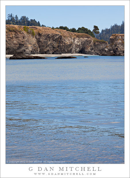
Blue Water, Beach and Bluffs, Mendocino

Blue Water, Beach and Bluffs, Mendocino - Beach and shoreline bluffs above the blue water of Mendocino Bay, California
Beach and shoreline bluffs above the blue water of Mendocino Bay, California

Blue Water, Beach and Bluffs, Mendocino. Mendocino, California. August 28, 2012. © Copyright 2012 G Dan Mitchell – all rights reserved.

Beach and shoreline bluffs above the blue water of Mendocino Bay, California.

This photograph was made on the beach along the shoreline of Mendocino Bay, beneath the tall bluffs that line the area. The land extends to the west and curves a bit to the south, allowing me to photograph back along the curving beach, toward the inlet of the river that drains into the bay and the forested hills beyond. The light was interesting – fog was coming in along the coast and was overhead at my camera position, but clear just inland of me. This created soft and somewhat gray light on the foreground water, but allowed the further hills and forest to be in the light. It also made the interesting reflection on the calm water more visible.

G Dan Mitchell is a California photographer whose subjects include the Pacific coast, redwood forests, central California oak/grasslands, the Sierra Nevada, California deserts, urban landscapes, night photography, and more.
Blog | About | Flickr | Twitter | FacebookGoogle+ | 500px.com | LinkedIn | Email

Text, photographs, and other media are © Copyright G Dan Mitchell (or others when indicated) and are not in the public domain and may not be used on websites, blogs, or in other media without advance permission from G Dan Mitchell.