
Tag Archives: stock

Murphy Point and Murphy Hogback, Evening

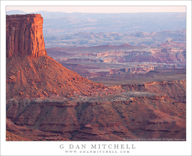
Murphy Point and Murphy Hogback, Evening - Evening light on the brow of Murphy Point, with Murphy Hogback leading to the right and the areas of the Green and Colorado Rivers confluence and the Needles beyond, Canyonlands National Park.
Evening light on the brow of Murphy Point, with Murphy Hogback leading to the right and the areas of the Green and Colorado Rivers confluence and the Needles beyond, Canyonlands National Park.

Murphy Point and Murphy Hogback, Evening. Canyonlands National Park, Utah. April 6, 2012. © Copyright 2012 G Dan Mitchell – all rights reserved.

Evening light on the brow of Murphy Point, with Murphy Hogback leading to the right and the areas of the Green and Colorado Rivers confluence and the Needles beyond, Canyonlands National Park.

When I photographed from the Green River Overlook in Canyonlands National Park back in early April, I arrived there in the evening with one shot definitely planned out ahead of time (though the conditions were, as they often are, a bit of a pleasant surprise once I arrived) and one sort of half planned. The first was a shot across the rugged terrain to the west and southwest through which the Green River has carved a deep and twisting canyon. The second was of more or less the same subject, but shot in vertical format with a longer lens and tracking some of the formations out toward the horizon.

Once there, I quickly figured out my shooting location – to be honest, there are quite a few options and unless you include cliff-top foreground subjects you don’t have to be terribly particular. I composed the first, landscape-orientation shot and then sort of went back and forth between that image and the vertical shot as the light evolved. As I did this and the low angle light began to cut through some of the haze a bit more, the terrain to my south that I had not really thought about earlier started to look a bit more interesting. From the Green River Overlook, the upper sandstone cliffs first curve back away from the river canyon, then run south, and once again extend a bit out into the canyon at Murphy Point, the impressive prominence at the left side of this photograph. One thousand feet below, Murphy Hogback – a flat-topped ridge – extends further toward the Green River. Beyond that the terrain extends into the distance, full of features that were unfamiliar to me but still very impressive – a series of plateaus, often with white rock edges, steep drop-offs into deep canyons, more distant and barely visible towers and other formations. From what I’ve read since then, I’m pretty certain that beyond the shoulder of Murphy Point, I am seeing the area roughly where the Green and Colorado Rivers meet and beyond that the area known as The Needles.

G Dan Mitchell is a California photographer whose subjects include the Pacific coast, redwood forests, central California oak/grasslands, the Sierra Nevada, California deserts, urban landscapes, night photography, and more.
Blog | About | Flickr | Twitter | FacebookGoogle+ | 500px.com | LinkedIn | Email

Text, photographs, and other media are © Copyright G Dan Mitchell (or others when indicated) and are not in the public domain and may not be used on websites, blogs, or in other media without advance permission from G Dan Mitchell.
Turk’s Head, Green River, Evening Haze

Turk's Head, Green River, Evening Haze - The Green River curves past Turk's Head in evening haze, Canyonlands National Park, Utah.
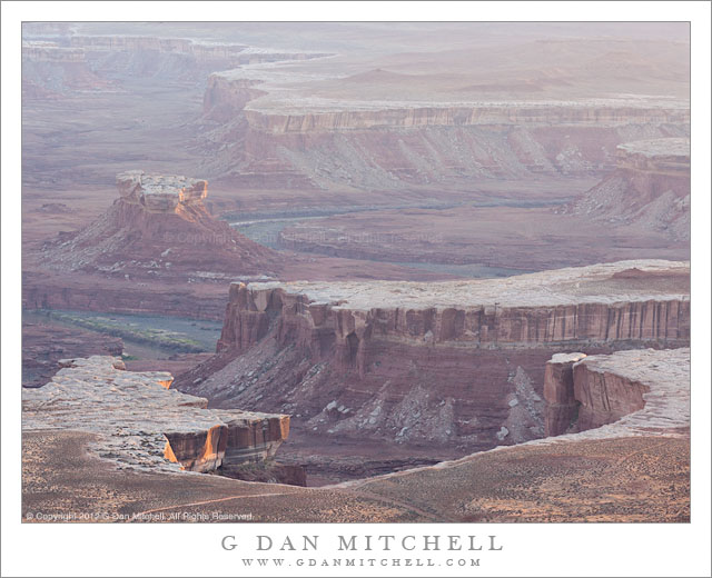
The Green River curves past Turk's Head in evening haze, Canyonlands National Park, Utah.

Turk’s Head, Green River, Evening Haze. Canyonlands National Park, Utah. April 6, 2012. © Copyright 2012 G Dan Mitchell – all rights reserved.

The Green River curves past Turk’s Head in evening haze, Canyonlands National Park, Utah.

Just to the west of the “Island in the Sky” area of Canyonlands National Park, the Green River flows though deep and rugged canyons on its way to the confluence with the Colorado River. The river and its tributary streams have cut thousands of feet down through the layers of rock, exposing plateaus and steep canyon walls and more sandstone than can be believed. At Turks’ Head the river winds through a very large S-curve that widens the lower part of the canyon.

I had begun shooting the evening light at the Green River Overlook somewhat earlier on this evening, and by the time I made this photograph the direct light was almost gone – a bit of it is still hitting the cliff faces at lower left and glancing across the tops of nearby flat areas. It was a rather hazy evening, which is part of what attracted me to this spot – I love shooting into or across back-lit haze which can almost glow in the right light and which can also enhance the sense of distance in the scene. Of course, most of the “glow” was gone by this time, and the result is something a lot more subtle with the most distant terrain above the far end of a tributary canyon almost disappearing into the distant haze.

G Dan Mitchell is a California photographer whose subjects include the Pacific coast, redwood forests, central California oak/grasslands, the Sierra Nevada, California deserts, urban landscapes, night photography, and more.
Blog | About | Flickr | Twitter | FacebookGoogle+ | 500px.com | LinkedIn | Email

Text, photographs, and other media are © Copyright G Dan Mitchell (or others when indicated) and are not in the public domain and may not be used on websites, blogs, or in other media without advance permission from G Dan Mitchell.
Viaduct and Blue Roof, Fremont District

Viaduct and Blue Roof, Fremont District - Seattle Viaduct and the blue roof on a building, Fremont District, Seattle, Washington
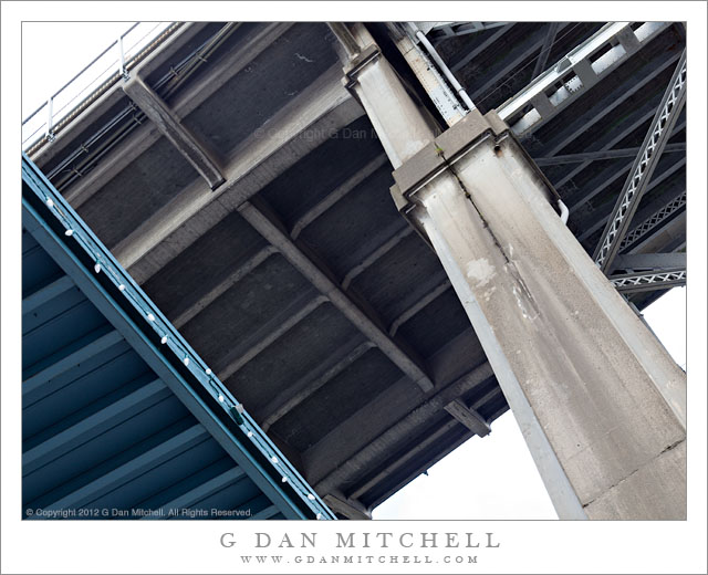
Seattle Viaduct and the blue roof on a building, Fremont District, Seattle, Washington

Viaduct and Blue Roof, Fremont District. Seattle, Washington. May 5, 2012. © Copyright 2012 G Dan Mitchell – all rights reserved.

Seattle Viaduct and the blue roof of a building, Fremont District, Seattle, Washington.

Yet another photograph from the early May photo walk I joined up with in the Fremont district of Seattle. A viaduct crosses the water high above this section of Seattle, and the structure more or less dominates portions of the view here. After shooting some of the buildings near where the photo walk began, I decided to head over towards this bridge and see what I could find to shoot there. I shot straight up at it from underneath, towards it from further away, along its length, and eventually made a few close-up photographs of details.

For this photograph I decided to create a more or less abstract juxtaposition of the underside of the bridge, almost straight overhead, and a bit of the underside of a building with a blue roof. Usually I might prefer to shoot such a thing from the tripod and perhaps even combine multiple exposures in post as a way of dealing with the wide dynamic range, but this time I simply composed the shot handheld and made a single exposure. Well, actually I made two slightly different versions, but still. :-)

G Dan Mitchell is a California photographer whose subjects include the Pacific coast, redwood forests, central California oak/grasslands, the Sierra Nevada, California deserts, urban landscapes, night photography, and more.
Blog | About | Flickr | Twitter | FacebookGoogle+ | 500px.com | LinkedIn | Email

Text, photographs, and other media are © Copyright G Dan Mitchell (or others when indicated) and are not in the public domain and may not be used on websites, blogs, or in other media without advance permission from G Dan Mitchell.

Man Crossing Bridge

Man Crossing Bridge - A man crossing a bridge in the China Basin area of San Francisco, California.
A man crossing a bridge in the China Basin area of San Francisco, California.

Man Crossing Bridge. San Francisco, California. April 20, 2012. © Copyright 2012 G Dan Mitchell – all rights reserved.

A man crossing a bridge in the China Basin area of San Francisco, California.

Two bridges crossing the inlet that passes AT&T Park (including “McCovey Cove”) are visible in this photograph. I’m not enough of a historian to have really researched these bridges, though I think that both are or were draw bridges and that at least the far one dates to the early twentieth-century. They are interesting anachronisms in areas that are now quite different from when the bridges were built – much of the surrounding area is not filled with new office and apartment/condominium buildings (one of which is barely seen along the waterfront at the far left) and often crowded with people attending San Francisco Giants games.

As I often do when photographing certain subjects, I began here by trying to create a composition that just included the structure of the bridge, especially with the pattern of the metal grate the forms the roadway here. Then I noticed that a pedestrian was approaching, so I thought I’d see if he might end up in interesting places within the composition. My original idea was to make the exposure before he reached the spot where his is located in this frame, but at the exact right moment a car crossed the bridge in front of him!

G Dan Mitchell is a California photographer whose subjects include the Pacific coast, redwood forests, central California oak/grasslands, the Sierra Nevada, California deserts, urban landscapes, night photography, and more.
Blog | About | Flickr | Twitter | FacebookGoogle+ | 500px.com | LinkedIn | Email

Text, photographs, and other media are © Copyright G Dan Mitchell (or others when indicated) and are not in the public domain and may not be used on websites, blogs, or in other media without advance permission from G Dan Mitchell.