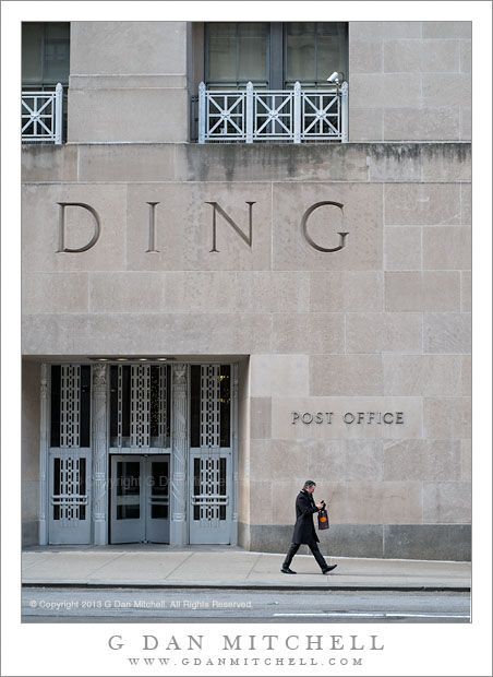
Tag Archives: stone

Branch on Playa, Panamint Valley

Branch on Playa, Panamint Valley

Branch on Playa, Panamint Valley. Death Valley National Park, California. March 31, 2011. © Copyright G Dan Mitchell – all rights reserved.

A lone branch lies across dried mud on the playa of Panamint Valley, Death Valley National Park.

First, a story about the location. My first visit to Death Valley was sometime in the late 1990s, when the “hiking and biking” club at my kids’ middle and high school did a trip there. The club is a long and interesting story that I don’t have time or space to describe here fully. Suffice it to say that the teacher, “Mr. Hodges,” had for decades taken kids on amazing outdoor adventures throughout the western United States every year, and that the trip that year was to involve visits to several places in the park and then a backpacking trip down to the Valley from up in the Teakettle Junction vicinity. This may sound like a crazy thing to do with a bunch of school kids, but the group had a record of success. I was along as a parent chaperone since my oldest son was a participant in the trip.

The “readers digest” version of the story of the trip is that, as is often the case near the beginning of April, we encountered an astonishing range of weather conditions. Early on it snowed and the wind blew at gale force levels. This forced us to abandon our initial backpacking plans after we had already camped overnight near Teakettle Junction, and to head back down to the Valley. We readjusted our plans and decided that we might still be able to do an overnight hike down the length of the upper Valley and (leaving out a bunch of intervening adventures in this narrative) we arrived at Stovepipe Wells and set up camp… just in time for a tremendous dust storm to blow in. The next morning the “bus” arrived that was to take the kids and a few of the chaperones home (the rest of us were in a truck carrying tons – literally – of gear on the roof rack and in a trailer) and we headed up to cross Towne Pass. It turned out that the “bus” (which was more or less a large airport shuttle-type van) was ill-equipped for these conditions and after struggling up the pass and then racing down the other side, the transmission blew out at the bottom of the descent into Panamint Valley. Those of us in the truck pulling the trailer arrived a few minutes later to find a group of scared kids and parents who had just experienced more excitement than they wanted.

I have a strong visual memory of “Mary,” one of the parents, who had just had a bit too much excitement walking quietly north away from the road and across this playa. Ever since that time, this place that most people would probably blow right past, has almost always warranted a stop as I passed by on my way out of the Valley. This trip was no exception. I left my camera gear in the car and just walked a ways out onto the playa. As I walked, even though I had been certain that my photography for this trip was finished, I started noticing some of the small details on the playa… and I went back to my car to get my camera, then returned and made a few hand-held exposures of some of these small subjects.

G Dan Mitchell Photography | Flickr | Twitter | Facebook | Email
Text, photographs, and other media are © Copyright G Dan Mitchell (or others when indicated) and are not in the public domain and may not be used on websites, blogs, or in other media without advance permission from G Dan Mitchell.

Red Rock Gully

Red Rock Gully
Red Rock Gully

Red Rock Gully. Death Valley National Park, California. March 29, 2011. © Copyright G Dan Mitchell – all rights reserved.

A red rock gully and wash in the Panamint Range of Death Valley National Park.

I have driven past this area along the road from Death Valley up to Wildrose Canyon quite a few times, and as I do I always am impressed by the many convoluted little canyons and odd and interesting rock formations. Most often I have been on my way to some other place or the light wasn’t quite right, but I always take a look and make a mental list of little spots to keep an eye on. This particular little canyon is one you might not even notice unless you were looking carefully as you passed it. It is in a narrow section of the lower canyon where it is one of many such little landscapes. On this morning I was coming back down from shooting up higher in the Panamints and I was watching carefully as I drove, frequently pulling over to stop and check things out more carefully. At first I almost drove past this spot, but it looked like the light might be interesting this time so I quickly stopped and backed up and made a series of photographs including this one.

The question of how to frame this scene was an interesting one. As is often the case I cover more than one base and shoot the subject in several ways. Initially I worked with a vertical orientation that includes a bit more of the rough terrain a bit higher in the canyon. That image may still see the light of day! But as I shot the scene I also realized that I could use a horizontal orientation too, more tightly frame the entrance to the small canyon, and give up some of the upper canyon formations.

With many subjects I would prefer softer light, and I would probably try to shoot much earlier in the day or come back in the evening. But this canyon, I think, works well in the light of a bit later in the morning when the sun has topped the ridge and direct light hits the top of the rocks and reflects into the recesses a bit more.

G Dan Mitchell Photography | Flickr | Twitter | Facebook | Email
Text, photographs, and other media are © Copyright G Dan Mitchell (or others when indicated) and are not in the public domain and may not be used on websites, blogs, or in other media without advance permission from G Dan Mitchell.

Eroded Sandstone, Point Lobos

Eroded Sandstone, Point Lobos

Eroded Sandstone, Point Lobos. Point Lobos State Reserve, California. July 20, 2010. © Copyright G Dan Mitchell – all rights reserved.

Patterns in eroded shoreline sandstone rocks at the Point Lobos State Reserve, California.

The rugged Point Lobos shoreline in places exposes some very interesting rocks, including sections like this one where layers of different colored sand stone are gradually worn away, revealing underlying layers of different colors and textures and sometimes exposing surprising color contrasts. On days when the light is very soft (or very boring!) I may seek out some of these rocks and photograph them since the softer light lets details appear that might easily be washed out in harsher light.

G Dan Mitchell Photography | Flickr | Twitter | Facebook | Email
Text, photographs, and other media are © Copyright G Dan Mitchell (or others when indicated) and are not in the public domain and may not be used on websites, blogs, or in other media without advance permission from G Dan Mitchell.

Glacial Erratics and Trees, Lembert Dome

Glacial Erratics and Trees, Lembert Dome

Glacial Erratics and Trees, Lembert Dome. Yosemite National Park, California. June 5, 2010. a© Copyright G Dan Mitchell – all rights reserved.

Glacial erratics and trees at the base of Lembert Dome, Tuolumne Meadows, Yosemite National Park.

This photograph was made last spring in early June, when I drove over Tioga Pass on a quick one-day jaunt right around the time that the road was re-opened for the season after its annual winter closure. The road opened a bit later than usual in 2010 due to above average and late snow fall, and when I crossed there was as much or more snow than I recall seeing up there.

This was one of my marathon drive days. I started well before dawn in the San Francisco Bay Area and arrived in Yosemite in the very early morning and without any concrete plan – except that the ideas of visiting waterfalls and possibly getting up to Tioga Pass were on my mind. I did stop near the Valley first, where I made a series of photographs of Cascade Creek in virtually full flow. After doing this and making a very brief visit to the Valley, I decided to visit the high country along Tioga Pass road. I went just over the pass before turning back. There was so much snow still around that in most places it still looked much more like winter than like early June.

I finally started heading back to the west, as my plan was to return late to the SF Bay Area. As I left the pass and started down toward Tuolumne Meadows the light began to get “interesting” as the sun dropped lower in the west and some high clouds occasionally softened the light. As I drove past Lembert Dome I thought of photographing these glacial erratics that sit on the apron at the bottom of the dome before making one last stop to photograph snow-covered Tuolumne Meadow in the day’s last light.

G Dan Mitchell Photography | Flickr | Twitter | Facebook | Email
Text, photographs, and other media are © Copyright G Dan Mitchell (or others when indicated) and are not in the public domain and may not be used on websites, blogs, or in other media without advance permission from G Dan Mitchell.