Tag Archives: water

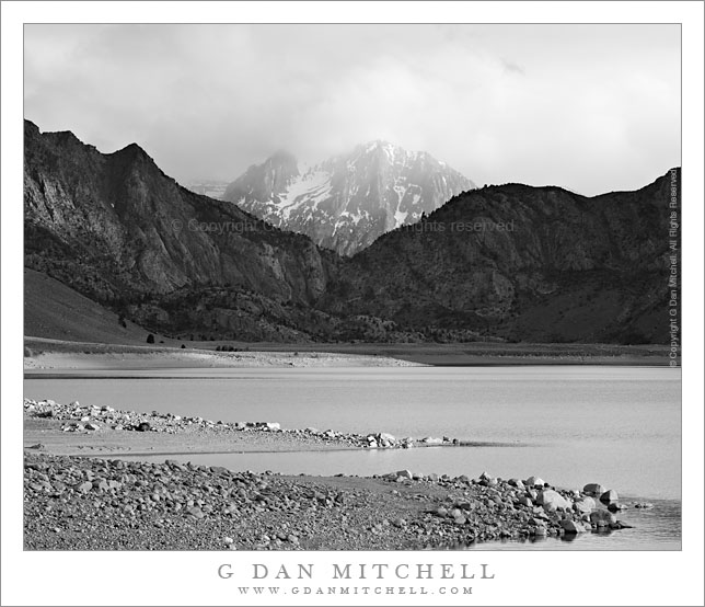
Clearing Storm, Carson Peak and Grant Lake

Clearning Storm, Carson Peak and Grant Lake

Clearing Storm, Carson Peak and Grant Lake. June Lakes Loop, California. June 7, 2009. © Copyright G Dan Mitchell – all rights reserved.

A late spring storm clears from the summit of Carson Peak above Grant Lake along the June Lakes Loop, California.

I’ll start by saying that I hope I have identified this peak correctly. I did not know its name when I made the photograph, and I think I’ve lined it up with the other geographic features on my map correctly – but if any one has a different ID on this peak please let me know.

I came to Grant Lake (which is actually, and obviously, a reservoir) from the back route, arriving by way of some dirt roads coming in from highway 395. I arrived at the dam and followed the road across, stopping in the middle to make some photographs when I saw this late light on the lake and shoreline with the peak gradually emerging from the remnants of this late-spring storm.

This photograph is not in the public domain. It may not be used on websites, blogs, or in any other media without explicit advance permission from G Dan Mitchell.

keywords: late, spring, storm, clears, clearing, carson, peak, grant, lake, june, lakes, loop, road, reservoir, rock, peninsula, low, water, surface, boulder, sun, light, evening, eastern, sierra, nevada, mountain, range, ridge, shadow, tree, forest, rock, valley, tower, cloud, blue, sky, landscape, travel, scenic, stock

Iceberg Lake, Minarets

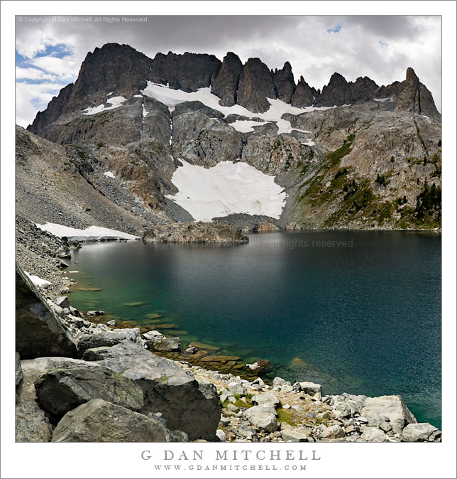
Iceberg Lake, Minarets

Iceberg Lake, Minarets. Sierra Nevada Mountains, California. July 27, 2007. © Copyright 2007  G Dan Mitchell – all rights reserved.

Submerged boulders along the rocky alpine shoreline of Iceberg Lake in front of the spires of the Minarets as afternoon thunderclouds begin to build.

This is an older photograph that I’ve been thinking of working on and posting for some time. Two summers ago in late July I was on a backpack trip into Ediza Lake and then on to Garnett and Thousand Island. We spent a few nights a beautiful Lake Ediza and on one of the layover mornings I decided to wander on up to Iceberg Lake. Iceberg Lake (along with Cecile Lake) is located along a high and almost cross-country route between Ediza and Minarets Lakes, and it passes very close beneath the east side of the imposing ridge of the Minarets. I made it as far as Iceberg when I noticed that that the thunderclouds were already building quickly at noon – so I stopped for a few photographs before high-tailing it back down to camp. (I almost made it back before the rain and hail started! :-)

My history with this lake goes back to some earlier trips as well. Many years ago I decided to do a sol0 backpack trip beneath the Minarets, comprising a loop up to Minaret Lake, then up into the rough country above the lake, across it, and down past Iceberg Lake to Ediza Lake. (I have been to the latter lake many times!) It was, as I recall, early in a season that was a reasonably snowy one. When I picked up my permit the range tried to warn me of the dangers of crossing while there was still a lot of snow in a few spots, but being younger than I am now and foolish in very different ways, I decided to ignore him. The climb above Minaret Lake went well, once I found a route through rocks that went up to the right. I had a small accident that left some scars that I still bear—I stepped into a hole between rocks and managed to bang up one leg a bit. I continued on and eventually found myself at the top of the saddle at the upper left corner of this photograph, looking down at a very steep slope that was covered with snow that dropped right into the lake. I was without any of the aids to mountain travelers that might have come in handy here such as trekking poles (didn’t use them back in those days), an ice ax, or crampons. I found a small piece of wood that I might use for an emergency self arrest—or so I imagined— and stepped gingerly down this slope.

G Dan Mitchell is a California photographer and visual opportunist whose subjects include the Pacific coast, redwood forests, central California oak/grasslands, the Sierra Nevada, California deserts, urban landscapes, night photography, and more.
Blog | About | Flickr | Twitter | FacebookGoogle+ | 500px.com | LinkedIn | Email

Text, photographs, and other media are © Copyright G Dan Mitchell (or others when indicated) and are not in the public domain and may not be used on websites, blogs, or in other media without advance permission from G Dan Mitchell.

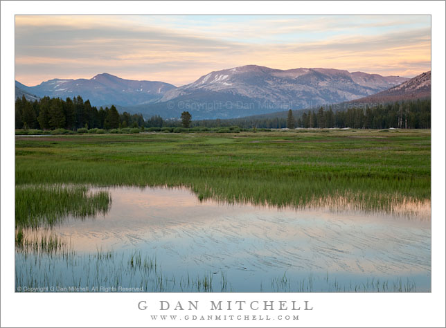
Meltwater Pond and Grasses, Mount Gibbs and Kuna Crest, Tuolumne Meadows

Meltwater Pond and Grasses, Mount Gibbs and Kuna Crest, Tuolumne

Meltwater Pond and Grasses, Mount Gibbs and Kuna Crest, Tuolumne Meadows. Yosemite National Park, California. July 8, 2009. © Copyright G Dan Mitchell – all rights reserved.

Evening sky is reflected in a meltwater pond at the edge of a Tuolumne Meadows with Mount Gibbs and the Kuna Crest beyond, Yosemite National Park, California.

A rather peaceful evening scene, again at the seasonal runoff ponds near the west end of Tuolumne Meadows on and early July evening. I’m always intrigued by the patterns that the partially submerged meadow grasses make in these ponds, and here in the way they interrupt the sky reflected in the surface of the pond. On this evening I was also struck by the unusual coloration of the clouds about the summit of Mt Gibbs (at the left) and Mammoth Peak and barely-sunlit Kuna Crest in the center and right half of the frame.

This photograph is not in the public domain. It may not be used on websites, blogs, or in any other media without explicit advance permission from G Dan Mitchell.

keywords: tuolumne, meadows, melt, water, pond, pool, reflection, grass, flowers, blue, pink, green, sierra, nevada, mountain, range, crest, ridge, evening, dusk, sunset, light, mount, gibbs, kuna, crest, mammoth, peak, tree, forest, river, slope, hill, nature, scenic, landscape, travel, nature, stock

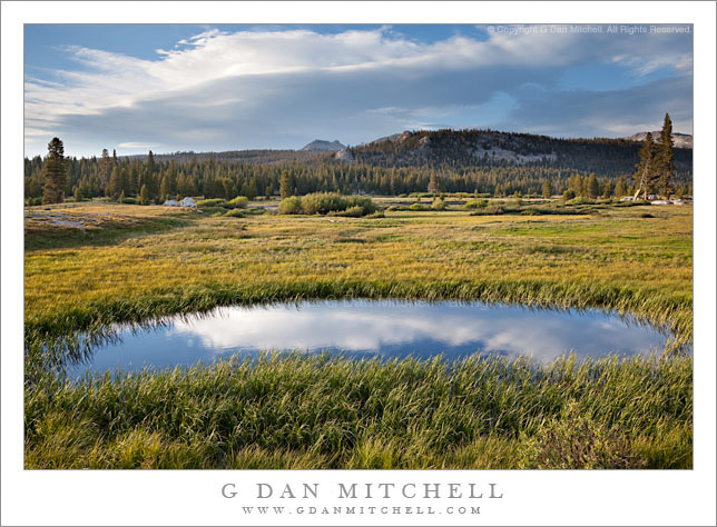
Spring Pond, Tuolumne Meadows

Spring Pond, Tuolumne Meadows

Spring Pond, Tuolumne Meadows. Yosemite National Park, California. July 10, 2009. © Copyright G Dan Mitchell – all rights reserved.

Late afternoon light on a small runoff pond at the edge of Tuolumne Meadows with impressive clouds in the distance, Yosemite National Park, California.

If you have ever been to Tuolumne Meadows – or at least spent a few moments wandering about there – you probably know this little pond. It is right alongside the road where the John Muir Trail crosses on its way across the Meadows to Parsons Lodge, the old Sierra Club facility on the far side of the meadow by Soda Springs. It is a frequently-photographed feature of the meadow, though often it is used as a foreground for photographs of Lembert Dome. This photograph looks a bit fore towards the north or northwest towards Ragged Peak and the north boundary country of the park.

This photograph is not in the public domain. It may not be used on websites, blogs, or in any other media without explicit advance permission from G Dan Mitchell.

keywords: tuolumne, meadows, spring, summer, green, golden, grass, pool, pond, water, surface, blue, reflection, sky, clouds, plants, rocks, trees, forest, ridge, mountain, hill, ragged, peak, boulder, landscape, nature, scenic, travel, yosemite, national park, california, usa, high, sierra, nevada, range, lenticular, gray, stock