Tag Archives: Cloud

Ice and Snow on Tioga Pass and Tioga Lake

Ice and Snow on Tioga Pass and Tioga Lake

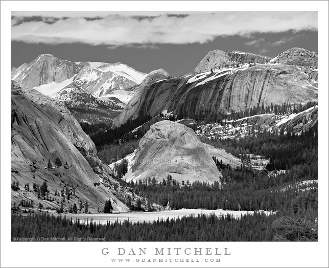
Ice and Snow on Tioga Pass and Tioga Lake. Near Yosemite National Park, California. June 5, 2010. © Copyright G Dan Mitchell – all rights reserved.

Late afternoon shadows fall across the frozen surface of Tioga Lake with Tioga Pass and the snow-covered peaks of Kuna Crest beyond.

On June 5 I made my first “summer season” visit to the Sierra of the year. Usually I mark the start of the post-winter part of the year by heading to Yosemite Valley to experience the waterfalls close up during the peak flow of the meltwater-filled rivers. This year I had time for a one-day trip and I did, indeed, start in the Valley. The waterfalls are close to as big as they get right now, and the Merced River is close to reaching flood stage, with large meadow areas of the Valley already under water. (The latter is actually a normal condition at the peak of the runoff cycle.) However, after shooting in the Valley into mid-morning, I decided to head elsewhere because the crowds were oppressive and because tran-Sierra Tioga Pass Road had opened this very morning.

I’ve been over Tioga Pass Road before on or close to the first day that the route is open, but I haven’t seen conditions like these up there since the mid-1990s. (In 1996, IIRC, the pass didn’t open until July 1 after a very heavy and late winter.) There was still snow almost everywhere along the road. It would be possible to ski or snow-shoe in many areas and, in fact, there were people engaged in just those activities. Melting water was everywhere. In places where I have never seen water before there were roaring creeks, often pouring down next to or even onto the roadway. All lakes and ponds are nearly or completely frozen still. Tuolumne Meadows itself is still completely covered by snow… except where the flooding Tuolumne River has created a giant, fast-moving lake.

I made this photograph at Tioga Lake late in the afternoon after making a traditional visit to the “Who Nellie Deli” in Lee Vining for the ritual fish tacos. Long shadows from nearby peaks and clouds fall across the frozen surface of the lake, the saddle of Tioga Pass is beyond, and in the farthest distance it is still winter on the peaks of Kuna Crest.

This photograph is not in the public domain and may not be used on websites, blogs, or in other media without advance permission from G Dan Mitchell.

G Dan Mitchell Photography | Twitter | Friendfeed | Facebook | Facebook Fan Page | Email

Technical Data:
Canon EOS 5D Mark II
Canon EF 24-105mm f/4 L IS USM at 90mm
ISO 200, f/9, 1/1000 second

keywords: yosemite, national, park, sierra, nevada, mountain, spring, nature, tioga, lake, pass, mammoth, peak, kuna, crest, ridge, winter, conditions, spring, early, season, june, 2010, snow, ice, frozen, shadow, rock, boulder, reflection, melt, forest, sky, cloud, evening, road, eastern, landscape, winter, nature, stock

Two Pelicans in Flight

Two Pelicans in Flight

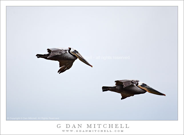
Two Pelicans in Flight. North of Santa Cruz, California. May 15, 2010. © Copyright G Dan Mitchell – all rights reserved.

Two pelicans in flight along high bluffs above the Pacific Ocean coast north of Santa Cruz, California.

More pelicans… These were photographed along the bluff just south of Waddell Beach, the coastal section of Big Basin Redwoods State Park. I’ve observed the pelicans – and other birds – skim past very close to the edge of the bluff and then descend to the outlet of Waddell Creek on the beach.

The light on this day was not especially conducive to landscape photography – it had been a sort of murky, gray morning – so I thought I’d use the softer light (with its tendency to reduce blown highlights and to bring out shadow detail) to try to photograph these great birds. The pelicans are often seen along the coast in California, though their numbers had seemed to decrease over the winter. On this morning it seemed like they might be increasing once again.

This photograph is not in the public domain and may not be used on websites, blogs, or in other media without advance permission from G Dan Mitchell.

G Dan Mitchell Photography | Twitter | Friendfeed | Facebook | Facebook Fan Page | Email

Technical Data:
Canon EOS 5D Mark II
Canon EF 100-400mm f/4.5-5.6 L IS USM at 400mm
ISO 400, f/5.6, 1/1600 second

keywords: pelican, pelagic, bird, sea, shore, sky, cloud, two, nature, wildlife, bif, santa cruz, county, davenport, california, usa, north america, fly, flight, wing, beak, flock, group, wild, highway, one, pacific, ocean, bluff, stock, northern

Clouds at Last Light – Badwater Basin and Panamint Range

Clouds at Last Light - Badwater Basin and Panamint Range

Clouds at Last Light – Badwater Basin and Panamint Range. Death Valley National Park, California. March 29, 2010. © Copyright G Dan Mitchell – all rights reserved.

Last light of the day over the Panamint Range casts its glow on Badwater Basin salt flats and clouds.

In what may be the last gasp of my obvious attempt to extract as many photographs as possible from this late March evening in Badwater Basin, here is yet another. This one was photographed well after the sun had set, and I had turned my camera away from the expansive view north into Death Valley and to the east towards the Panamint Range and Telescope Peak over which I saw this wing-shaped cloud. While there was a thin band of relatively bright sky above the Panamint Range, everything else was heading quickly toward twilight. (The longer exposures listed in the “technical data” below will confirm the light levels.)

I’ve previously mentioned the subjective issue of how to handle the very blue tone of the “white” salt formations here. The salt is, no doubt, really white – but after the sun dips below the Panamint Range the only light is that of the very blue sky, and the salt picks this up. If you think about it you can see it on the scene, but when you look at the photographs later it is absolutely clear. I’ve been thinking for several weeks about how I’d handle this one, and I decided over a week ago that I’d “go for the blue” with this rendition.

This photograph is not in the public domain and may not be used on websites, blogs, or in other media without advance permission from G Dan Mitchell.

G Dan Mitchell Photography | Twitter | Friendfeed | Facebook | Facebook Fan Page | Email

Technical Data:
Canon EOS 5D Mark II
Canon EF 17-40mm f/4 L USM at 17mm
ISO 100, f/16, composite of .8 second and 1.3 second exposures

keywords: panamint, mountain, range, badwater, basin, salt, flats, polygons, desert, death valley, national, park, california, usa, north america, landscape, travel, scenic, dusk, twilight, sunset, cloud, large, dark, sky, nature, blue, evening, pink, stock, pattern

Badwater Basin Salt Flats, Dusk

Badwater Basin Salt Flats, Dusk

Badwater Basin Salt Flats, Dusk. Death Valley National Park, California. March 29, 2010. © Copyright G Dan Mitchell – all rights reserved.

Newly formed salt polygons extend to the horizon as evening clouds gather above the Badwater Basin salt flats, Death Valley National Park, California.

This is one more – and perhaps the last – in a series of photographs I shot on a late-March evening in the Badwater Basin of Death Valley National Park. The light goes through a long and interesting transitional process at this location. Because of the tall Panamint Mountain range to the west, the direct sun leaves the surface of the salt flats quite early, though the hills along the east side of the valley and the more distant mountains can still be sunlit for some time. Once the sun drops behind the Panamints, the “white” salt actually can end up being quite blue since it is illuminated entirely by the diffused light from the blue sky. As I have mentioned before this creates some interesting subjective questions for the photographer. Should the salt be white? Should it be as blue as it looks in the capture? Should it be somewhere in between? I’ve seen interesting and effective photographs that seemed to take each of these approaches.

In this case, because I shot a bit before actual sunset and while some clouds reflected less blue light onto the playa surface, the need to alter to color balance was diminished a bit – which is not to say that I didn’t do some work to balance the colors so that they looked more like what I remembered. A second issues is related, namely that the sky remains very bright while the salt flat surface, in deep shade, is very dark by comparison. On the scene, the eyes/brain compensate and the difference seems less than what the camera records. So, again, some adjustment in post is needed. In this case I made two exposures one stop apart. On just barely handled the brightest portions of the sky without blowing out, while the other did a better job of holding the details for the shadowed salt formations. I combined the two source images in post.

This photograph is not in the public domain and may not be used on websites, blogs, or in other media without advance permission from G Dan Mitchell.

G Dan Mitchell Photography | Twitter | Friendfeed | Facebook | Facebook Fan Page | Email

Technical Data:
Canon EOS 5D Mark II
Canon EF 17-40mm f/4 L USM at 17mm
ISO 100, f/16, composite of 1/13 second and 1/6 second exposures

keywords: badwater, basin, salt, flat, desert, polygon, water, playa, crust, pattern, sky, cloud, evening, dusk, sunset, blue, mountain, ridge, range, distant, death valley, national, park, california, usa, north america, landscape, nature, scenic, travel, geology, horizon, stock