Tag Archives: gravel

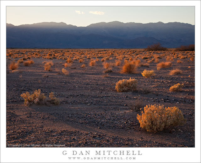
Last Light on Desert Plants, Death Valley

Last Light on Desert Plants, Death Valley

Last Light on Desert Plants, Death Valley. Death Valley National Park, California. February 20, 2011. © Copyright G Dan Mitchell – all rights reserved.

The last light of a winter day lights the plants at the edge of a wash in Death Valley National Park, California.

On this afternoon I drove a bit up the east side of the Valley past the turnoff to Beatty looking for subjects to shoot along the hills that parallel the valley. I did not initially have a specific shot in mind, since this isn’t an area that I know very well – I’ve mostly driven past it on my way to some other place. I was generally thinking of a couple of possibilities. One was an early evening photograph looking up into one of the very large canyons, probably include the massive washes that spill out of them and aiming for a very rugged looking image. I looked for a few such places and played around a bit with the idea of shooting one or two, but it wasn’t quite working for me.

I have included some low hills along this area called, I believe, the Kit Fox Hills, in some photographs that I have made of this area from way over near Mesquite Dunes. These hills which sit just above the road toward Scotty’s Castle have intrigued me, so I had also looked at them. As I passed them earlier in the afternoon I made a mental note to come back and check out one particular spot in better light, and when the canyon idea didn’t seem to work out I decided to head back there. I was probably a bit late in settling on this subject, but I arrived while the sun was still (just barely) above the tops of the ridges on the opposite side of the Valley. I grabbed equipment and went to a spot where I thought I could use a particular mesquite plant as foreground to a shot of these low hills, but then this backlit expanse of the floor of the Valley filled with these small, rugged plants caught my attention. I decide to photograph them before turning my attention back to the mesquite and hills. As I shot a few frames the sun began to drop behind the far hills much sooner than I expected, and this was close to the last photograph I made before I was in shadow.

All seriousness aside, someone just suggested that an alternate title for this photograph might be “Sea of Tribbles!” ;-)

G Dan Mitchell Photography | Flickr | Twitter | Facebook | Email
Text, photographs, and other media are © Copyright G Dan Mitchell (or others when indicated) and are not in the public domain and may not be used on websites, blogs, or in other media without advance permission from G Dan Mitchell.

Winter Evening Sky, Panamint Range, Death Valley

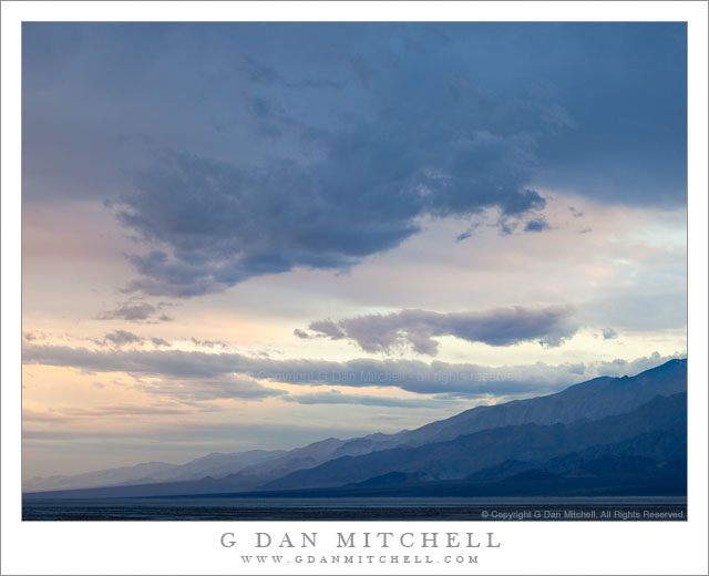
Winter Evening Sky, Panamint Range, Death Valley

Winter Evening Sky, Panamint Range, Death Valley. Death Valley National Park, California. February 18, 2011. © Copyright G Dan Mitchell – all rights reserved.

Winter clouds fill the evening sky above the eastern slopes of the Panamint Range in Death Valley National Park.

After the long drive from the San Francisco Bay Area I arrived at Stovepipe Wells in Death Valley and set up my camp in the mid afternoon and hung out a bit, thinking about the prospects of late afternoon and evening shooting. Because a weather front was coming in (the forecast called for a chance of rain in the Valley and pretty much certain light snow over the passes) the clouds were increasing, in many directions heading past the point of “picturesque” and more towards “socked in.” I was hoping for some evening light – or early rain? – but it seemed less promising as evening approached. In circumstances like these I may come up with a few possible shooting alternatives ahead of time, watch as conditions develop, and make a last-minute decision about where to go based on observations and hunches.

So, late in the afternoon I stopped near Death Valley Dunes and worked to line up some long shots that filled the background of the dunes with the rugged shapes of the Grapevine Mountains, and then headed towards the junction with the road to Scotty’s Castle to try to figure out if the light held more promise to the north or the south. It didn’t look totally promising in either direction, but I thought that I might be able to make something out of the haze to the south as the ridges on both sides of the Valley receded, especially if a bit of glow in the sky turned up right at sunset. So, south it was.

I drove just a little ways in that direction to a point where the road curves a bit towards the east to travel around the northernmost area of salt flats in what I think of as the lower valley – this is the area a bit south of the Salt Creek cutoff. From here there is a fairly open view all the way down to the end of the Valley, and it looked like the clouds were going to evolve in some interesting ways. It didn’t look like I would see a gaudy, brilliantly colorful sunset, but something more subtle and quiet looked like it might happen. As the light began to fade I made a series of photographs whose subject was largely the sky and the atmospheric recession along the Panamint Range (shown here) on the west side of the Valley and the mountains just beyond Furnace Creek.

G Dan Mitchell Photography | Flickr | Twitter | Facebook | Email
Text, photographs, and other media are © Copyright G Dan Mitchell (or others when indicated) and are not in the public domain and may not be used on websites, blogs, or in other media without advance permission from G Dan Mitchell.
Titus Canyon Road

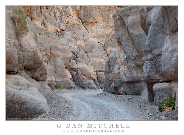
Titus Canyon Road
Titus Canyon Road

Titus Canyon Road. Death Valley National Park, California. March 28, 2010. © Copyright G Dan Mitchell – all rights reserved.

I made this photograph during midday hours after walking a ways up into the canyon from its mouth – the alternative to making the very long drive over the Grapevine Mountains from Amargosa Valley. (I have done the latter a few times, too.) While most Death Valley subjects tend to be appealing in the early morning or in the evening, many of the canyons can be at their best during the middle of the day, especially the very deep and narrow canyons like lower Titus Canyon. Here the canyon narrows down to the point that there is only room of a single gravel track, and twists and turns around rocky outcroppings. The light striking the upper canyon walls – out of the range of this photograph – reflects down into the canyon and produces soft, diffused illumination.

This photograph is not in the public domain and may not be used on websites, blogs, or in other media without advance permission from G Dan Mitchell.
G Dan Mitchell Photography
About | Flickr | Twitter | Facebook | Google+ | 500px.com | LinkedIn | Email

Text, photographs, and other media are © Copyright G Dan Mitchell (or others when indicated) and are not in the public domain and may not be used on websites, blogs, or in other media without advance permission from G Dan Mitchell.
(Basic EXIF data may be available by “mousing over” large images in posts. Leave a comment if you want to know more.)


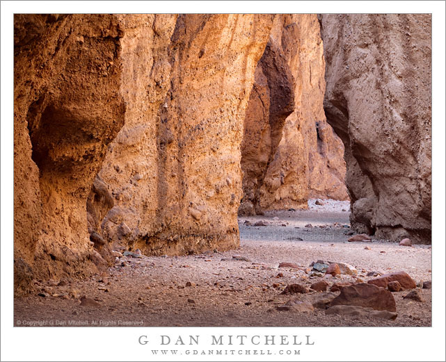
Natural Bridge Canyon

Natural Bridge Canyon

Natural Bridge Canyon. Death Valley National Park, California. March 27, 2010. © Copyright G Dan Mitchell – all rights reserved.

A gravel wash in the bottom of the narrow confines of Natural Bridge Canyon, Death Valley National Park.

These narrow canyons, of which there are a number of great examples in Death Valley, can provide some interesting photographic opportunities, but they also can pose some real challenges. Much of the rock in these places is, frankly, rather drab and of low contrast. However, at the right time of day and on a day with the right light and in the right parts of these canyons, the glowing light reflected down into the canyons from overhead rock walls can produce warm and diffused light and bring interesting colors to the place.

I made an unusual decision to use a very long focal length for this photograph – it was shot with a 100-400mm zoom at 330 mm. More typically I would probably tend to use wide angle focal lengths in the confines of such a canyon. However, because I wanted to juxtapose the different colors and shapes of the sections of canyon wall along the narrow and twisting wash, I chose the long lens to compress the distance. Although I think the photograph creates a feeling that I’m positioned very close to the foreground rocks and the darker bit of canyon wall on the left, I was actually quite a distance back from this spot.

G Dan Mitchell Photography
About | Flickr | Twitter | Facebook | Google+ | 500px.com | LinkedIn | Email

Text, photographs, and other media are © Copyright G Dan Mitchell (or others when indicated) and are not in the public domain and may not be used on websites, blogs, or in other media without advance permission from G Dan Mitchell.

(Basic EXIF data may be available by “mousing over” large images in posts. Leave a comment if you want to know more.)