
Tag Archives: northwest

Tree Farm and Hills

“Tree Farm and Hills” — The bare winter trunks of a tree farm against a backdrop of low hills, Skagit Valley, Washington

This is perhaps a bit of a subtle photograph. While shooting in the Skagit Valley of Washington, my brother Richard and I took a break from photographing trumpeter swans and snow geese and went looking for bald eagles, which hang out nearby in large numbers. We eventually found several of them in various trees in the area, including in the upper branches of these large groves of trees that I think may be poplars that are part of a tree farm. (Our first attempt with the eagles was a classic. We saw a beautiful bird in a tree at the edge of the grove right alongside the road. We stopped. We carefully fitted the right long lenses. We got out. We aimed… and the eagle flew away.)

While standing around looking for the birds I was fascinated by the regular patters of these very slender and closely spaced trees in the tree farms that were along the road. The light was very muted due to overcast, and the trees themselves don’t provide a whole lot of light/dark contrast. I found a section of the grove that I liked and then worked my position so that I could get the diagonal of the more distant and out of focus ridge to cut across the background and angle down to the right.


G Dan Mitchell is a California photographer and visual opportunist. His book, “California’s Fall Color: A Photographer’s Guide to Autumn in the Sierra” (Heyday Books) is available directly from him.

G Dan Mitchell: Blog | Bluesky | Mastodon | Substack Notes | Flickr | Email


All media © Copyright G Dan Mitchell and others as indicated. Any use requires advance permission from G Dan Mitchell.
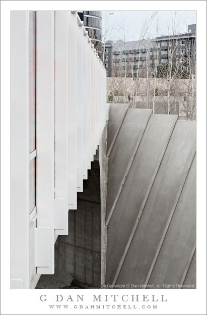
Bridge, Olympic Sculpture Park

Bridge, Olympic Sculpture Park

Bridge, Olympic Sculpture Park. Seattle, Washington. January 1, 2008. © Copyright 2008 G Dan Mitchell – all rights reserved.

A bridge crosses railroad tracks at the Olympic Sculpture Park, Washington.

Back in 2008 I travelled to Seattle on mostly family business. I arrived a bit early and ended up spending some time wandering around the Olympic Sculpture Park, a place I enjoy both for the art and for the architecture and other features of this public space.

The bridge across the railroad tracks had interested me previously, but I’ve found it a difficult subject to photograph – somewhat surprisingly, since it seems to me like such an obvious thing to photograph. So in this image I more or less obscured most of the bridge itself, leaving not much more than the white vertical supports along its exterior and its overall shape and mass. I thought that the relationships between the texture of the metal bridge and the concrete underneath was interesting, as were some of the relationships between various shapes and angles. As I have done in a few other recent photographs, I played around with “pure” color and black and white renditions of the image – in the end deciding to sort of split the difference, thinking that a somewhat de-saturated color image might be most in line with my memory of the place and the scene on that winter day.

G Dan Mitchell Photography
About | Flickr | Twitter | Facebook | Google+ | 500px.com | LinkedIn | Email

Text, photographs, and other media are © Copyright G Dan Mitchell (or others when indicated) and are not in the public domain and may not be used on websites, blogs, or in other media without advance permission from G Dan Mitchell.
(Basic EXIF data may be available by “mousing over” large images in posts when this page is viewed on the web. Leave a comment if you want to know more.)

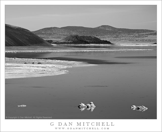
Black Point and Negit Island, Mono Lake Shoreline

Black Point and Negit Island, Mono Lake Shoreline

Black Point and Negit Island, Mono Lake Shoreline. Mono Lake, California. October 10, 20120. © Copyright G Dan Mitchell – all rights reserved.

The north shoreline of Mono Lake leads from foreground offshore tufa past the base of Black Point to Negit Island and beyond.

You would never know it from this black and white photograph of the austere desert landscape around Mono Lake, but I was there to photograph… fall aspen color! Earlier in the day I had photographed further south along the eastern slopes of the Sierra, gradually working my way north with a plan of heading back to the “west side” over Tioga Pass at the end of the day after doing a last bit of  fall color photography near Conway Summit and Dunderberg Road in late-afternoon light. By mid-afternoon I had made it to Lee Vining for an espresso stop at Latte Da and a break to check some email and so forth. Soon it was time to get into position for the low angle sun that would light the aspens a bit later, so I headed north out of town.

The road north from Lee Vining skirts the west shore of Mono Lake. Before leaving the lake there is a turn-off to another road that passes along the north shore of Mono Lake and can take you to places such as Black Point. I often stop at this turn-off since it provides a slightly elevated view of the larger terrain around the lake including the low hills to the east and Mono Craters and higher mountains to the south. On a typical blue sky mid-afternoon I might not make any photographs, but something about the light and the forms of the shoreline, Black Point, and Negit Island leading into the distance convinced me to make a few exposures, using a long lens to compress the distance.

This photograph is not in the public domain and may not be used on websites, blogs, or in other media without advance permission from G Dan Mitchell.
G Dan Mitchell Photography
Flickr | Twitter | Facebook Fan Page | Facebook | Friendfeed | Email

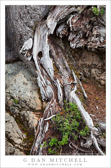
Roots and Rocks

Roots and Rocks
Roots and Rocks

Roots and Rocks. Mt. Baker-Snoqualmie National Forest, Washington. August 28, 2010. © Copyright G Dan Mitchell – all rights reserved.

Weathered tree roots stretch across boulders at Mt. Baker-Snoqualmie National Forest, Washington.

I made this photograph at our first stop after we arrived at the Mt. Baker-Snoqualmie National Forest. (Technically, that isn’t quite true, since we had earlier stopped at the “ranger station” to ask some questions, but this was the first “real” stop for photography.) The road into this area twists and turns as it ascends toward and then past a ski area, and here we couldn’t help but pull over at a hairpin curve that provided a panoramic overlook to the valley below and the ridges to the east (?) of our position. Although the original reason for stopping was this dramatic view, I soon found nearby “intimate landscapes” to also be very interesting. While I often hike and climb long distances to find my photographs… for this one the tripod was on asphalt and the subject right next to the road.

On a technical note, for this photograph I used a lens that I’m increasingly fond of for photographing subjects like this one, the Canon EF 70-200mm f/4 L USM (link to B&H). I find it useful to be able to put a bit of distance between myself and subjects in which the entire image may include only a few square feet, and the ability to fine tune the composition with the zoom is very useful. Although I didn’t do it in this photography, working with a slightly longer focal length also lets me have the option of isolating the subject against an out of focus background. I have the non-IS version of the lens – because that was the only version available back when I got mine – though I would almost certainly get the IS version if I were to replace it.

This photograph is not in the public domain and may not be used on websites, blogs, or in other media without advance permission from G Dan Mitchell.

G Dan Mitchell Photography | Twitter | Friendfeed | Facebook | Facebook Fan Page | Email