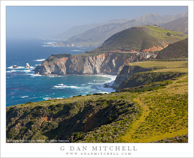
Tag Archives: route

Rugged Terrain, Lower Titus Canyon

Rugged Terrain, Lower Titus Canyon

Rugged Terrain, Lower Titus Canyon. Death Valley National Park, California. March 28, 2010. © Copyright G Dan Mitchell – all rights reserved.

Details of the rugged cliffs and walls rising above lower Titus Canyon in Death Valley National Park.

Titus Canyon Road is one of the marvels of Death Valley National Park. It begins in high desert of Amargosa Valley near the town of Beatty and the ghost town of Rhyolite, winds over the summit of the Grapevine Mountains, drops precipitously into upper Titus Canyon, passes a number of historically interesting sites, passes through a very narrow and deep section in the lower canyon, and then suddenly emerges into the vastness of Death Valley.

In the lower section of the canyon, the wash becomes very narrow, passing through a twisty slot canyon and is, in places, barely wide enough for the one-lane gravel road. Here the walls of the canyon press tightly together and rise steeply for hundreds of feet. Some places are so deep that the sun rarely penetrates to the bottom.

Fortunately for the preservation of the canyon the road is horrible, at least if you are used to more civilized driving. It is a one-way road and the whole thing is gravel. Sections are in decent shape, but it other places the road passes over narrow and twisty sections next to precipitous drop-offs and then dives steeply into deep canyons. At times the route is closed after heavy rains or other conditions that make the route impassable.

Fortunately, the section that is perhaps the most impressive in many ways – the deep slot canyon near the bottom – is easily accessible by foot from Death Valley. After a short drive up to the canyon entrance on a gravel road to a parking area, you can enter the canyon on foot and walk up as far as you want. This photograph was made within the lower mile of the canyon during the late morning, when the light penetrates more deeply into the canyon and creates a glow on the canyon walls.

G Dan Mitchell Photography
About | Flickr | Twitter | Facebook | Google+ | 500px.com | LinkedIn | Email

Text, photographs, and other media are © Copyright G Dan Mitchell (or others when indicated) and are not in the public domain and may not be used on websites, blogs, or in other media without advance permission from G Dan Mitchell.

(Basic EXIF data may be available by “mousing over” large images in posts. Leave a comment if you want to know more.)


Iceberg Lake, Minarets

Iceberg Lake, Minarets

Iceberg Lake, Minarets. Sierra Nevada Mountains, California. July 27, 2007. © Copyright 2007  G Dan Mitchell – all rights reserved.

Submerged boulders along the rocky alpine shoreline of Iceberg Lake in front of the spires of the Minarets as afternoon thunderclouds begin to build.

This is an older photograph that I’ve been thinking of working on and posting for some time. Two summers ago in late July I was on a backpack trip into Ediza Lake and then on to Garnett and Thousand Island. We spent a few nights a beautiful Lake Ediza and on one of the layover mornings I decided to wander on up to Iceberg Lake. Iceberg Lake (along with Cecile Lake) is located along a high and almost cross-country route between Ediza and Minarets Lakes, and it passes very close beneath the east side of the imposing ridge of the Minarets. I made it as far as Iceberg when I noticed that that the thunderclouds were already building quickly at noon – so I stopped for a few photographs before high-tailing it back down to camp. (I almost made it back before the rain and hail started! :-)

My history with this lake goes back to some earlier trips as well. Many years ago I decided to do a sol0 backpack trip beneath the Minarets, comprising a loop up to Minaret Lake, then up into the rough country above the lake, across it, and down past Iceberg Lake to Ediza Lake. (I have been to the latter lake many times!) It was, as I recall, early in a season that was a reasonably snowy one. When I picked up my permit the range tried to warn me of the dangers of crossing while there was still a lot of snow in a few spots, but being younger than I am now and foolish in very different ways, I decided to ignore him. The climb above Minaret Lake went well, once I found a route through rocks that went up to the right. I had a small accident that left some scars that I still bear—I stepped into a hole between rocks and managed to bang up one leg a bit. I continued on and eventually found myself at the top of the saddle at the upper left corner of this photograph, looking down at a very steep slope that was covered with snow that dropped right into the lake. I was without any of the aids to mountain travelers that might have come in handy here such as trekking poles (didn’t use them back in those days), an ice ax, or crampons. I found a small piece of wood that I might use for an emergency self arrest—or so I imagined— and stepped gingerly down this slope.

G Dan Mitchell is a California photographer and visual opportunist whose subjects include the Pacific coast, redwood forests, central California oak/grasslands, the Sierra Nevada, California deserts, urban landscapes, night photography, and more.
Blog | About | Flickr | Twitter | FacebookGoogle+ | 500px.com | LinkedIn | Email

Text, photographs, and other media are © Copyright G Dan Mitchell (or others when indicated) and are not in the public domain and may not be used on websites, blogs, or in other media without advance permission from G Dan Mitchell.

El Capitan, Morning

El Capitan, Morning

El Capitan, Morning. Yosemite Valley, California. May 10, 2009. © Copyright G Dan Mitchell – all rights reserved.

Morning light illuminates a small portion of the vertical face of El Capitan, Yosemite Valley. (black and white)

This is a black and white version of a photograph I posted earlier. Back in May I was photographing spring trees and meadow plants in El Capitan Meadow in Yosemite Valley. Since I happened to have the 400mm lens on the camera at one point I decided to do a few close shots of some sections of the face of the monolith. In the full size versions of this photograph I can make out a number of individual climbers and even see the ropes stretched between them.

This photograph is not in the public domain. It may not be used on websites, blogs, or in any other media without explicit advance permission from G Dan Mitchell.

keywords: national park, travel, yosemite, valley, national park, morning, spring, el capitan, cliff, face, mountain, rock, granite, climber, flake, crack, monolith, shadow, landscape, scenic, geology, big, wall, route, rope, haul sack, belay, lead, stock

El Capitan, Morning

El Capitan, Morning

El Capitan, Morning. Yosemite Valley, California. May 10, 2009. © Copyright G Dan Mitchell – all rights reserved.

Morning light illuminates a small portion of the vertical face of El Capitan, Yosemite Valley.

While photographing the oaks in El Capitan Meadow in early May I decide to point my lens up towards the vertical face of El Capitan. In the full size version of this print you can pick out a number of climbers in various places across the cliff.

This photograph is not in the public domain. It may not be used on websites, blogs, or in any other media without explicit advance permission from G Dan Mitchell.

keywords: national park, travel, yosemite, valley, national park, morning, spring, el capitan, cliff, face, mountain, rock, granite, climber, flake, crack, monolith, shadow, landscape, scenic, geology, big, wall, route, rope, haul sack, belay, lead, stock