
Tag Archives: sand

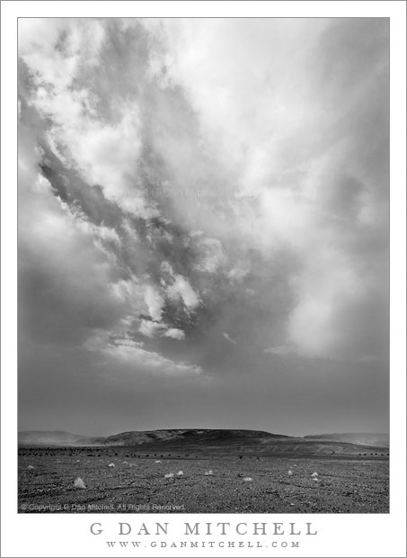
Dust Storm, Death Valley

Dust Storm, Death Valley

Dust Storm, Death Valley. Death Valley National Park, California. April 3, 2009 © Copyright 2009 G Dan Mitchell – all rights reserved.

A building dust storm begins to obscure the sky above Death Valley, California.

In retrospect, there were hints that this tremendous dust storm was coming prior to its actual arrival. Very early in the morning I had been photographing at another location and the light and atmosphere were a bit unusual. The dawn and very early morning light was beautifully warm, but the distant peaks were slightly obscured by a sort of atmospheric haze that is hard to describe but which I now recognize as being associated with incoming dust storms. Soon, large and impressive clouds began to appear high in the deep blue sky, but at about the same time the air closer to the bottom of Death Valley started to look increasingly opaque.

I left my early morning shooting location and began my trip home from Death Valley. After a stop at Furnace Creek – to treat myself to a real breakfast after days of camping – I headed north towards Stovepipe Wells. As I headed north I began to see the obvious clouds of blowing dust accumulating along the Grapevine Mountains, and shortly before the turn to Stovepipe I encountered the boundary between the relatively clear air and the murk of the dust storm that was growing directly ahead and off to my left.

Before entering the cloud – I had not choice since my route went that direction – I pulled over within perhaps a quarter-mile of the edge of the storm. Not wanting to risk dust getting into my camera, I unpacked my gear inside the car and decided to just use the lens that was already fitted to the camera. I stepped outside to find that lines of wind-blown dust were already streaming along the ground and that the atmosphere had taken on the strange and electric feel of these storms. Off to my left, the dust was beginning to kick up among some low, dark hills across a nearby wash, while a gap in the dust clouds momentarily left open a window to the bright sky and high clouds above.

Related: See my posts on Photographing Death Valley

G Dan Mitchell is a California photographer whose subjects include the Pacific coast, redwood forests, central California oak/grasslands, the Sierra Nevada, California deserts, urban landscapes, night photography, and more.
Blog | About | Flickr | Twitter | Facebook | Google+ | 500px.com | LinkedIn | Email

Text, photographs, and other media are © Copyright G Dan Mitchell (or others when indicated) and are not in the public domain and may not be used on websites, blogs, or in other media without advance permission from G Dan Mitchell.
Mount Conness and Lower Young Lake, Sunset

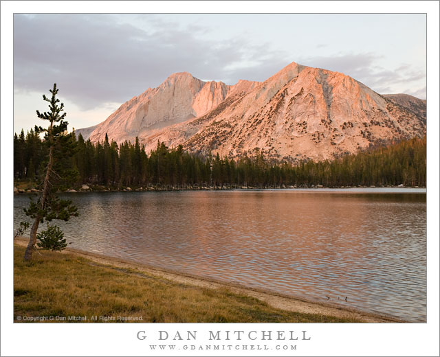
Mount Conness and Lower Young Lake, Sunset

Mount Conness and Lower Young Lake, Sunset. Yosemite National Park, California. September 11, 2007. © Copyright G Dan Mitchell – all rights reserved.

Alpenglow lights Mount Conness above Lower Young Lake in the Yosemite National Park back-country.

I was recently going through a large portion of my archive in search of a variety of photographs of Mount Conness, a well-known peak along the northeast edge of Yosemite National Park on the crest of the Sierra. This is perhaps not the best known peak in Yosemite for most people – they are obviously going to be far more familiar with the cliffs and domes around Yosemite Valley or with Mount Lyell (the tallest peak in the park) or perhaps Mount Dana (second highest peak, and towering above the Tioga Pass entrance.) Mount Conness is found a bit further “north” along the crest, and while it may be less known, it is certainly no less visible once you know where to look. You can see it in the distance towering above Tenaya Lake if you stop at the iconic Olmsted Point overlook. It is visible from many places along the road to Tuolumne Meadows. Once you get away from roads and into the high country it can be seen from almost any high point with an open view in the direction of the peak, including places like Vogelsang High Sierra Camp.

This photograph was made on a quiet late-season evening at Lower Young Lake, a place that I return to frequently, most of the time in the off-season when fewer people are there and the fall colors of the high country are starting to appear. The peak (and many other features in this area) are beautifully illuminated late in the day as this high ridge is open without obstruction to the west. The light on the peak was magical on this evening, being colorful and contrasting with the higher and more drab clouds, but not being as gaudily bright as it can be on other evenings.

G Dan Mitchell Photography | Flickr | Twitter (follow me) | Facebook (“Like” my page) | LinkedIn | Email
Text, photographs, and other media are © Copyright G Dan Mitchell (or others when indicated) and are not in the public domain and may not be used on websites, blogs, or in other media without advance permission from G Dan Mitchell.
Pacific Coast Near Bixby Creek

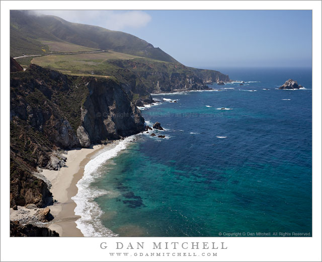
Pacific Coast Near Bixby Creek

Pacific Coast Near Bixby Creek. Big Sur, California. May 13, 2011. © Copyright G Dan Mitchell – all rights reserved.

The blue Pacific Ocean and rugged fog-topped coastal hills meet along the Big Sur coastline at Bixby Creek.

On a nearly perfect spring morning – despite the ominous sounding Friday the 13th date! – I spent a morning along the upper Big Sur coast below Monterey, California. The brilliant sun was modulated a bit by some atmospheric haze over the ocean and occasional fog clouds clustered around the tops of the coastal hills. Since I made quite a few stops along the way, I only went as far south as the iconic Bixby Bridge. This photograph was made from very near the spot where thousands (including me!) have photographed the bridge itself – it is out of the frame to the left. On this morning, the bridge didn’t interest me much at all, so I instead photographed the wild and steep coastline, with its spring green contrasting with the brilliant blues of the coastal waters below the rugged cliffs. At the very lower left corner, Bixby Creek flows across the beach and into the Pacific Ocean. Above, the coast highway rises across the top of the coastal bluffs on its way south.

G Dan Mitchell Photography | Flickr | Twitter (follow me) | Facebook (“Like” my page) | LinkedIn | Email
Text, photographs, and other media are © Copyright G Dan Mitchell (or others when indicated) and are not in the public domain and may not be used on websites, blogs, or in other media without advance permission from G Dan Mitchell.

Hill Near Mesquite Flat, Dusk

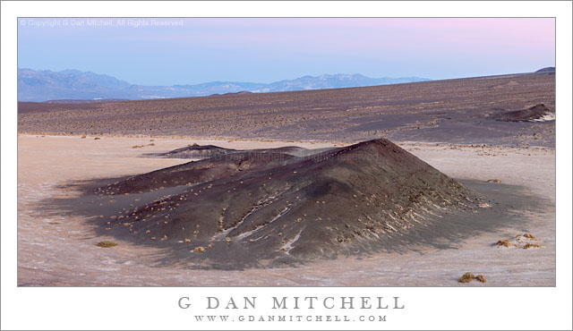
Hill Near Mesquite Flat, Dusk

Hill Near Mesquite Flat, Dusk. Death Valley National Park, California. March 29, 2011. © Copyright G Dan Mitchell – all rights reserved.

Dusk light above a hill near Mesquite Flat in Death Valley, backed by a large alluvial fan from Tucki Mountain.

At the end of this day I was shooting from the top of a low hill in the Valley east of Stovepipe Wells, and there were interesting subjects throughout almost the entire 360 degree panorama around this elevated position. With this in mind, I had chosen to use the long 100-400mm zoom so that I could have some flexibility in composing elements of this huge scene.

I was mainly working with things that were in the large arc to my west (dunes and Cottonwood mountains and base of Tucki Mountain), north (the main Valley and transverse dunes), and east (the mountains running along that edge of the Valley) since the further subjects of the lower Valley were more or less out of sight beyond the alluvial fan that appears in the photograph. But I kept being intrigued by the low, dark hill on the flats below the similar hill on which I was standing. There is a row of them stretching from near the Devils Cornfield area up and across this alluvial fan. As the evening light transitioned towards post-sunset light I saw that the glow from clouds (a bit of which is visible in the distance above the Black Mountains) was lighting this hill and the surrounding flats in an interesting and colorful way.

But I had a little problem. I was still working a number of subjects and once and I really needed to keep shooting that 100-400. 100mm was still too long for this scene, but I didn’t have time to remove it and put on a shorter lens. I figured that I could simply change the camera to vertical orientation, very carefully level the tripod, and include the whole scene in four panning vertical frames that I could stitch together later. People often do this so that they can produce extremely high-resolution image, but that wasn’t my goal at all. In any case, it worked, and not only did I manage to get the shot that needed a wider lens, but as a bonus it is a very high-resolution shot.

G Dan Mitchell Photography | Flickr | Twitter (follow me) | Facebook (“Like” my page) | LinkedIn | Email
Text, photographs, and other media are © Copyright G Dan Mitchell (or others when indicated) and are not in the public domain and may not be used on websites, blogs, or in other media without advance permission from G Dan Mitchell.