
Tag Archives: state

Evening Clouds and Rocks, Point Lobos

Evening Clouds and Rocks, Point Lobos

Evening Clouds and Rocks, Point Lobos. Point Lobos State Reserve, California. January 8, 2011. © Copyright G Dan Mitchell – all rights reserved.

Evening clouds over the Pacific Ocean and offshore rocks at Point Lobos State Reserve.

It always strikes me as odd that at the most beautiful time of day at Point Lobos, almost all of the park visitors have left. In the evening as the sun goes down over the Pacific and the fog may or may not roll in, there are often only a handful of people left in the park, a good number of them photographers. On this Sunday evening it may have been that some were discouraged by the low clouds that had come in earlier in the afternoon, but sometimes these clouds dissipate or are lit up from behind at sunset – at that is precisely what happened on this evening. The low clouds began to thin and as they did so beams of light came through the breaks in the clouds and painted the surface of the Pacific with patchy light. A bit later, after I made this photograph, the clouds thinned even more and high, pink sunset clouds appeared briefly. And there was not another person anywhere near me to see it.

This photograph is not in the public domain and may not be used on websites, blogs, or in other media without advance permission from G Dan Mitchell.
G Dan Mitchell Photography
Flickr | Twitter (follow me) | Facebook (“Like” my page) | LinkedIn | Email

Text, photographs, and other media are © Copyright G Dan Mitchell (or others when indicated) and are not in the public domain and may not be used on websites, blogs, or in other media without advance permission from G Dan Mitchell.


Monterey Cypress Forest, Point Lobos

Monterey Cypress Forest, Point Lobos

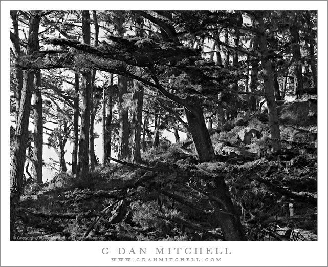
Monterey Cypress Forest, Point Lobos. Point Lobos State Reserve, California. January 8, 2011. © Copyright G Dan Mitchell – all rights reserved.

Winter light on the Monterey Cypress forest growing on a hillside at Point Lobos State Reserve.

This is perhaps an absurdly complex photograph – I think it is going to have to end up as a large print at some point. This is a section of Monterey Cypress forest that I’ve walked through many times on the trail along the north shore at Point Lobos State Reserve near Carmel, California. These trees grow along the tops of rocky bluffs above the ocean and in some sheltered places can grow tall and straight.

I made this photograph in what almost amounted to midday sun, though there were a few fog clouds floating around to mute the harshest character of the light a bit. But I knew that the photograph was going to be tricky. The first challenge was finding a location from which to shoot it – most angles are blocked by closer trees or are inaccessible. I finally found a spot along the trail where I could shoot between trees using a longer focal length. Then there was the problem of the light, or more accurately the dynamic range between the clouds and a bit of blue sky and the much darker backlit and shadowed trees in the foreground. Finally, it is just a very complex scene, and making any kind of coherent composition out of it was tricky. I don’t know yet whether it succeeds or not, but the idea was to use the angled division between the darker and very complex lower right side and the lighter upper left side with its vertical tree trunks, and to let the darker foreground tree connect it all together. That was the idea, anyway!

This photograph is not in the public domain and may not be used on websites, blogs, or in other media without advance permission from G Dan Mitchell.
G Dan Mitchell Photography
Flickr | Twitter | Facebook Fan Page | Facebook | Friendfeed | Email

Technical Data:
Canon EOS 5D Mark II (at B&H)
Canon EF 70-200mm f/4 L USM at 94mm (at B&H)
ISO 100, f/16, 1/40 second


Black Point and Negit Island, Mono Lake Shoreline

Black Point and Negit Island, Mono Lake Shoreline

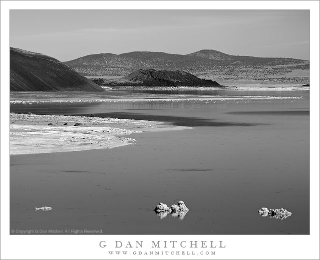
Black Point and Negit Island, Mono Lake Shoreline. Mono Lake, California. October 10, 20120. © Copyright G Dan Mitchell – all rights reserved.

The north shoreline of Mono Lake leads from foreground offshore tufa past the base of Black Point to Negit Island and beyond.

You would never know it from this black and white photograph of the austere desert landscape around Mono Lake, but I was there to photograph… fall aspen color! Earlier in the day I had photographed further south along the eastern slopes of the Sierra, gradually working my way north with a plan of heading back to the “west side” over Tioga Pass at the end of the day after doing a last bit of  fall color photography near Conway Summit and Dunderberg Road in late-afternoon light. By mid-afternoon I had made it to Lee Vining for an espresso stop at Latte Da and a break to check some email and so forth. Soon it was time to get into position for the low angle sun that would light the aspens a bit later, so I headed north out of town.

The road north from Lee Vining skirts the west shore of Mono Lake. Before leaving the lake there is a turn-off to another road that passes along the north shore of Mono Lake and can take you to places such as Black Point. I often stop at this turn-off since it provides a slightly elevated view of the larger terrain around the lake including the low hills to the east and Mono Craters and higher mountains to the south. On a typical blue sky mid-afternoon I might not make any photographs, but something about the light and the forms of the shoreline, Black Point, and Negit Island leading into the distance convinced me to make a few exposures, using a long lens to compress the distance.

This photograph is not in the public domain and may not be used on websites, blogs, or in other media without advance permission from G Dan Mitchell.
G Dan Mitchell Photography
Flickr | Twitter | Facebook Fan Page | Facebook | Friendfeed | Email

Shoreline Plants and Sandstone, Weston Cove

Shoreline Plants and Sandstone, Weston Cove

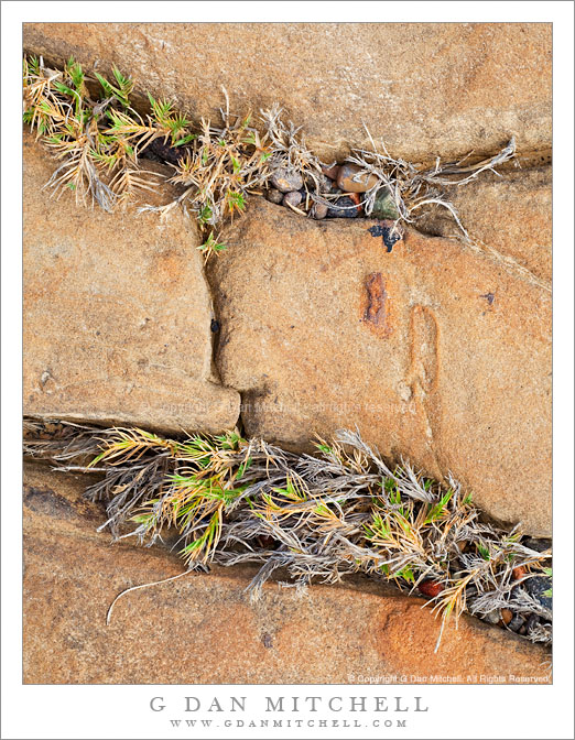
Shoreline Plants and Sandstone, Weston Cove. Point Lobos State Reserve, California. October 23, 2010. © Copyright G Dan Mitchell – all rights reserved.

Plants grow in cracks in the sandstone along the shore of Weston Cove, Point Lobos State Reserve, California.

On this visit to Point Lobos, a place I photograph frequently, I wasn’t quite sure what conditions I would encounter. A Pacific weather front was approaching and I thought that I might encounter dismal, overcast conditions – but I was surprised to find it mostly sunny when I arrived. Even better, high, thin clouds were approaching the coast line and soon muted the direct sunlight, which made photographing these shoreline rock formations a more reasonable possibility during the late morning.

I’m pretty familiar with Point Lobos in general at this point, having visited the place from the time I was a child. I’m especially familiar with Weston Beach (or “cove,” as I like to think of it), with its circular shape, protective rock barrier, angled sandstone edges, and large pebbly “sand.” But as familiar as I am with this location, I almost alway find something new if I look around carefully enough, and these plants growing in the angular cracks in the sandstone were new to me.

This photograph is not in the public domain and may not be used on websites, blogs, or in other media without advance permission from G Dan Mitchell.

G Dan Mitchell Photography | Twitter | Friendfeed | Facebook | Facebook Fan Page | Email