
Tag Archives: highway

Owens Valley, Tungsten Hills, and Mount Tom

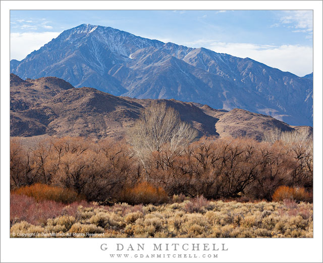
Owens Valley, Tungsten Hills, and Mount Tom - Massive Mount Tom rises above the Tungsten Hills and the high desert terrain of Owens Valley near Bishop, California.
Massive Mount Tom rises above the Tungsten Hills and the high desert terrain of Owens Valley near Bishop, California.

Owens Valley, Tungsten Hills, and Mount Tom. Eastern Sierra Nevada, California. January 2. 2012. © Copyright 2012 G Dan Mitchell – all rights reserved.

Massive Mount Tom rises above the Tungsten Hills and the high desert terrain of Owens Valley near Bishop, California.

When I’m driving to a photography destination, I often have to suppress the desire to stop and make photographs along the way. If I’m not careful, I can end up spending extra hours on the drive and arrive too late. (Sometimes I plan extra time for my long drives just to accommodate my need to stop and photograph en route.) I cope with sighting photographic potential as I drive by either pretending it isn’t there, filing it away for a later trip… or occasionally giving in and stopping.

As I headed down highway 395 on this winter afternoon, on my way to get a camp site in Death Valley, I was aware of the fact that if I took too long I would end up having to find a camp site and set up camp after dark when I arrived – and my destination was still hours away. But after descending to Round Valley just north of Bishop, California I became more aware of the interesting and somewhat unusually afternoon winter light and I finally just had to make a quick stop. The foreground Owens Valley high desert plants had lost all of their “green,” and now had a range of shades of yellow, brown, red, white, black, and even a bit of near-purple. Beyond them the Tungsten Hills began the rise from the valley toward the crest of the eastern escarpment of the Sierra, here dominated by the bulk of massive Mount Tom, a very tall peak that appears even larger because it sits more to the east than most of the other high peaks. The combination of backlight from above the range and high, thin clouds created a sort of muted sunny effect.

G Dan Mitchell is a California photographer whose subjects include the Pacific coast, redwood forests, central California oak/grasslands, the Sierra Nevada, California deserts, urban landscapes, night photography, and more.

Blog | About | Flickr | Twitter | FacebookGoogle+ | 500px.com | LinkedIn | Email

Text, photographs, and other media are © Copyright G Dan Mitchell (or others when indicated) and are not in the public domain and may not be used on websites, blogs, or in other media without advance permission from G Dan Mitchell.
Snowflakes, Grass, and Frozen Lake

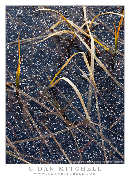
Snowflakes, Grass, and Frozen Lake - Fresh snowflakes among leaves of grass on the frozen surface of Siesta Lake, Yosemite National Park.
Fresh snowflakes among leaves of grass on the frozen surface of Siesta Lake, Yosemite National Park.

Snowflakes, Grass, and Frozen Lake. Yosemite National Park, California. January 16, 2012. © Copyright 2012 G Dan Mitchell – all rights reserved.

Fresh snowflakes among leaves of grass on the frozen surface of Siesta Lake, Yosemite National Park.

This past week we had the opportunity to do something that we’ll probably not get to do again – drive over Tioga Pass through Yosemite National Park in the middle of January. Until this year, the latest the road had been open was December 31. This year it was still open on January 17, though scheduled to close as I write this. It has been a very unusual weather year in many parts of California, including the Sierra. While the season began with earlier and heavier than usual snow storms way back in early October, this promising start to the snow season was just a tease. A month or so later, the tap was turned off and there was little rain through the end of the calendar year and on into January of 2012.

So with this once-in-a-lifetime opportunity about to end with the promise of snow this week, we drove up the night before and then headed over Tioga Pass Road to Lee Vining and back, stopping frequently along the way. The weather in the morning was a bit of a surprise. I knew that a weak weather system – that had not brought any rain – was departing the Sierra, but we were surprised when we encountered very light snow flurries as we drove up Crane Flat Road to the junction with highway 120, and this continued as we started up Tioga Pass Road. When we arrived at Siesta Lake we found it partly sunny but still trying to snow just a bit. I set up to make a photograph of some trees in cloud-softened light, but as soon as I was ready to shoot the light died! I waited for a while, but finally decided that the light wasn’t returning. I decided to wander over to this small lake and see what I could find along the shoreline – and I found these dormant grasses, half-submerged in winter ice, with a sprinkling of snowflakes on the surface of the ice.

G Dan Mitchell is a California photographer whose subjects include the Pacific coast, redwood forests, central California oak/grasslands, the Sierra Nevada, California deserts, urban landscapes, night photography, and more.
Blog | About | Flickr | Twitter | FacebookGoogle+ | 500px.com | LinkedIn | Email

Text, photographs, and other media are © Copyright G Dan Mitchell (or others when indicated) and are not in the public domain and may not be used on websites, blogs, or in other media without advance permission from G Dan Mitchell.
Sea Stacks, Rocky Point

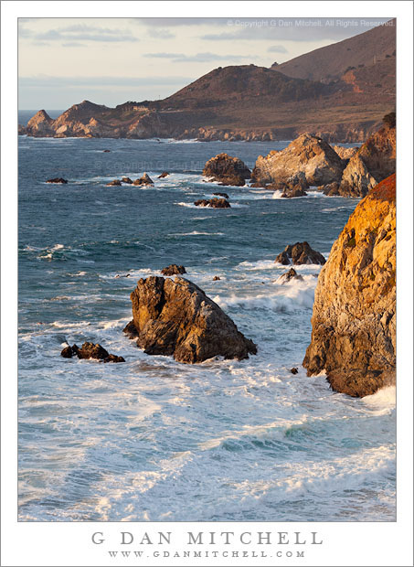
Sea Stacks, Rocky Point - Sea stacks dot the rugged Big Sur coastline at Rocky Point in evening light.

Sea Stacks, Rocky Point. Big Sur Coast, California. December 18, 2011. © Copyright 2011 G Dan Mitchell – all rights reserved.

Sea stacks dot the rugged Big Sur coastline at Rocky Point in evening light.

Continuing with the theme of evening light on the Big Sur coastline, I made this photograph along a favorite section of this portion of the California coast not long before sunset. (I left enough time after photographing this scene to drive back up the coast to more or less the small road-cut just visible in the upper right corner of the frame, from which I made another photograph shooting back into a large cove that is out of the range of this photograph to the right.) At this time, perhaps a half hour or so before sunset, the color of the light was warming and intensifying but had not yet reached that obviously red stage that comes right at and right after actual sunset.

The peninsula in the upper part of the photograph is known as Rocky Point and, among other things, is a spot many may know because of a restaurant perched there above these stunning views of the Pacific coast. (I hear it is pricey!) My camera position was at a pull-out along the Pacific Coast Highway at a spot where the road rises to pass around another bit of land that extends to the west, and this high camera position let me aim the camera down to minimize the sky and fill the frame with the ocean, the rocky sea stacks and cliffs, and the “point” itself. With the main variable being the unpredictable patterns in the surf, I made a series of exposures at what I thought might be likely moments and then selected from among them in post. I like the series of diagonal lines in the foreground surf and the way the low sun picks off the tops of the waves.

G Dan Mitchell is a California photographer whose subjects include the Pacific coast, redwood forests, central California oak/grasslands, the Sierra Nevada, California deserts, urban landscapes, night photography, and more.
Blog | About | Flickr | Twitter | FacebookGoogle+ | 500px.com | LinkedIn | Email

Text, photographs, and other media are © Copyright G Dan Mitchell (or others when indicated) and are not in the public domain and may not be used on websites, blogs, or in other media without advance permission from G Dan Mitchell.

Bixby Bridge, Pacific Coast Highway

Bixby Bridge, Pacific Coast Highway
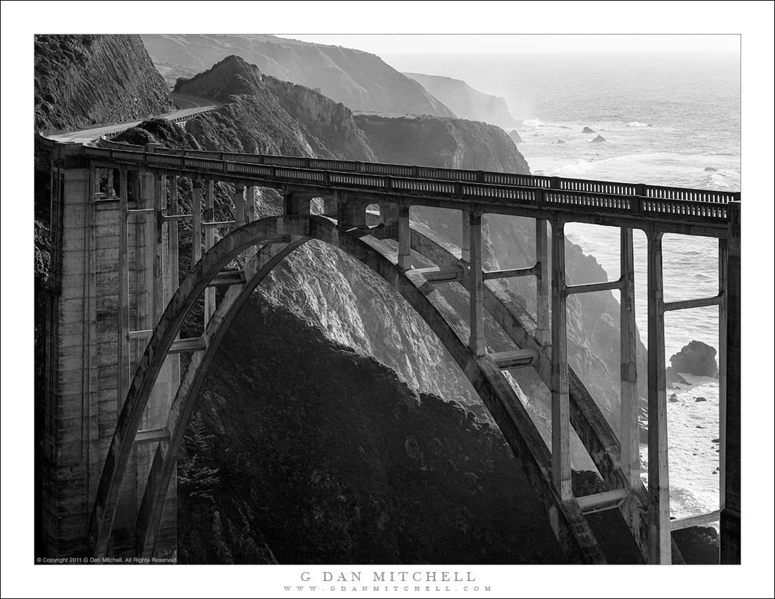
Black and white photograph of the Pacific Coast Highway crossing Bixby Bridge above the rugged Big Sur coastline of California.

Bixby Bridge, Pacific Coast Highway. © Copyright 2022 G Dan Mitchell.

The Pacific Coast Highway crossing Bixby Bridge above the rugged Big Sur coastline of California.

Bixby Bridge is one of the iconic sights along the rugged terrain of California Coast Highway (highway one) in the Big Sur area south of Monterey. Although it is not the only bridge of its type along this route – and, in my opinion, not necessarily the most visually impressive – it is no doubt the best known. Many people drive to this spot and stop to take in the view from high above the ocean and to photograph the bridge and this scenic section of the highway.

I have photographed this bridge before, and I’ve spent a bit of time scoping out alternative points of view. These include some locations visible from “behind” the bridge, up higher in the coastal hills, and from other nearby locations along the highway. While I have photographed the bridge from the backside in the past, the idea of photographing it in black and white from this vantage point was triggered by a photograph by Chris Morrison that I saw in an online photography forum. When I saw it, I almost immediately “saw” a slightly different composition of the bridge and the steep headlands and cliffs running south along the coast.


G Dan Mitchell is a California photographer and visual opportunist. His book, “California’s Fall Color: A Photographer’s Guide to Autumn in the Sierra” is available from Heyday Books, Amazon, and directly from G Dan Mitchell.

Blog | About | Twitter | Flickr | FacebookEmail

Links to Articles, Sales and Licensing, my Sierra Nevada Fall Color book, Contact Information.

Scroll down to leave a comment or question. (Click this post’s title first if you are viewing on the home page.)


All media © Copyright G Dan Mitchell and others as indicated. Any use requires advance permission from G Dan Mitchell.