Tag Archives: meadow

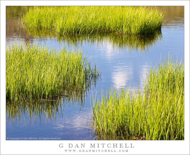
Shoreline Grasses and Subalpine Pond

Shoreline Grasses and Subalpine Pond

Shoreline Grasses and Subalpine Pond. Yosemite National Park, California. July 22, 2010. © Copyright G Dan Mitchell – all rights reserved.

Passing clouds reflected in the surface of a subalpine pond with summer meadow grass, Tioga Pass, Yosemite National Park.

I made this photograph on a special afternoon late last July. Although I had been across Tioga Pass earlier in the season when it was still very snowy, this was my first real visit to the summer high country of the season. It was a beautiful, sunny afternoon with just a few fluffy clouds floating about when I came to the meadows near Tioga Pass. The color of the meadow grasses was at just that perfect point that we think of when we imagine summer subalpine meadows – the intense green just before the wildflowers bloom and the inevitable change toward fall begins. (Yes, after some summers in the high country this cycle becomes clearer and clearer.)

I left my car, loaded up a pack of camera equipment, and just wandered the meadow for a good portion of the late afternoon, photographing the grass, the small trees, brooks and snow-melt ponds, and more. By sauntering about with no particular destination in mind I was able to “follow my nose” and find things that I had not seen in this meadow before, including more ponds than I had been aware of. These grasses were growing along the edge of an obscure pond with a complex and curving shoreline, and I photographed them as a few of those small clouds floated by.

G Dan Mitchell Photography | Flickr | Twitter (follow me) | Facebook (“Like” my page) | LinkedIn | Email
Text, photographs, and other media are © Copyright G Dan Mitchell (or others when indicated) and are not in the public domain and may not be used on websites, blogs, or in other media without advance permission from G Dan Mitchell.

Spring Flooding, Merced River

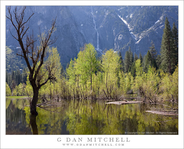
Spring Flooding, Merced River

Spring Flooding, Merced River. Yosemite Valley, California. May 7, 2011. © Copyright G Dan Mitchell – all rights reserved.

The Merced River overflows its banks during the spring runoff and floods surrounding meadows and lowlands in Yosemite Valley.

I’m tempted to go on about how the spring runoff is my favorite time of year in Yosemite Valley – but I’ve probably already written about how autumn is my favorite time, or how much I love winter in the Valley, and… :-)

In any case, there is a lot to like about spring in Yosemite Valley. For example, seasonal waterfalls that many visitors never see come to life. I believe that the thin fall across the Valley in this photograph is Sentinel Fall. There is another small one to its right in the v-shaped gully, but I do not know its name. The meadows come back to life and the trees begin to get their leaves, and there is green everywhere. Especially in a heavy snowfall year like this one, the Merced River rises as the snow begins to melt, and riverbanks overflow and meadows flood – as is happening in this photograph of a section of the river near Leidig Meadow along the north side of the Valley.

I’m surprised that there are not more photographs produced in this part of the Valley. I suppose the explanation may include the fact that few of the main iconic sights are directly visible from here, the current prohibition against parking along the road in this area, and the fact that parts of the river trail were underwater. But in the right light – which here can occur at times other than the typical early/late hours – Leidig Meadow and this curving section of the river with its shoreline trees can be very appealing, especially when the far canyon wall is muted by shadows.

I shot this a bit later in the day, not during the typical “golden hour” times at all. To get here I drove past this section of the road and walked back, alternately walking along the roadway (and occasionally leaving the narrow road as cars approached) and following the trail where it was not submerged. To make this photograph I walked down to the very edge of the rising Merced River and managed to find one spot that wasn’t too muddy.

G Dan Mitchell Photography | Flickr | Twitter (follow me) | Facebook (“Like” my page) | LinkedIn | Email
Text, photographs, and other media are © Copyright G Dan Mitchell (or others when indicated) and are not in the public domain and may not be used on websites, blogs, or in other media without advance permission from G Dan Mitchell.
Rocky Creek Bridge, Big Sur Coastline

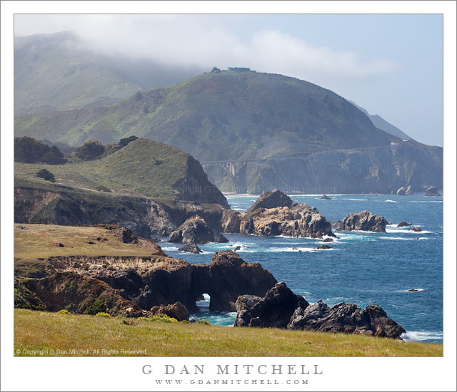
Rocky Creek Bridge, Big Sur Coastline

Rocky Creek Bridge, Big Sur Coastline. South of Monterey, California. May 13, 2011. © Copyright G Dan Mitchell – all rights reserved.

Bluff, cliffs, seastacks, and fog-shrouded coastal hills along the Big Sur coastline of California.

The bridge in the distance beneath the rounded, fog-topped hill is the Rocky Creek Bridge. (It is sometimes mistaken for the famous Bixby Bridge, which is a bit further south along the coast highway.) I’m very familiar with this area, having photographed from here many times. In fact, later on this morning I was up in the hills beyond the hilltop home while investigating a gravel road that heads back up into the mountains here.

I wanted to juxtapose a range of near and far bits of the bluffs above the shoreline cliffs in this scene. While the coastal meadows will turn brown very soon, on this mid-May date and in this relatively wet year they were still green. The coast highway travels along the upper part of the bluffs, often between the cliffs and the hills rising above. Beyond the bridge you can see the roadway rise to pass around another hill before descending toward the next creek to the south.

G Dan Mitchell Photography | Flickr | Twitter (follow me) | Facebook (“Like” my page) | LinkedIn | Email
Text, photographs, and other media are © Copyright G Dan Mitchell (or others when indicated) and are not in the public domain and may not be used on websites, blogs, or in other media without advance permission from G Dan Mitchell.
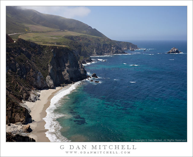
Pacific Coast Near Bixby Creek

Pacific Coast Near Bixby Creek

Pacific Coast Near Bixby Creek. Big Sur, California. May 13, 2011. © Copyright G Dan Mitchell – all rights reserved.

The blue Pacific Ocean and rugged fog-topped coastal hills meet along the Big Sur coastline at Bixby Creek.

On a nearly perfect spring morning – despite the ominous sounding Friday the 13th date! – I spent a morning along the upper Big Sur coast below Monterey, California. The brilliant sun was modulated a bit by some atmospheric haze over the ocean and occasional fog clouds clustered around the tops of the coastal hills. Since I made quite a few stops along the way, I only went as far south as the iconic Bixby Bridge. This photograph was made from very near the spot where thousands (including me!) have photographed the bridge itself – it is out of the frame to the left. On this morning, the bridge didn’t interest me much at all, so I instead photographed the wild and steep coastline, with its spring green contrasting with the brilliant blues of the coastal waters below the rugged cliffs. At the very lower left corner, Bixby Creek flows across the beach and into the Pacific Ocean. Above, the coast highway rises across the top of the coastal bluffs on its way south.

G Dan Mitchell Photography | Flickr | Twitter (follow me) | Facebook (“Like” my page) | LinkedIn | Email
Text, photographs, and other media are © Copyright G Dan Mitchell (or others when indicated) and are not in the public domain and may not be used on websites, blogs, or in other media without advance permission from G Dan Mitchell.