Tag Archives: north

Morning Squall, South Tufa

Morning Squall, South Tufa

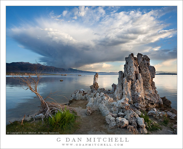
Morning Squall, South Tufa. Mono Lake, California. July 25, 2010. © Copyright 2010 G Dan Mitchell – all rights reserved.

The shoreline of Mono Lake as a morning squall drops rain over the Sierra Crest near Lee Vining, California.

This photograph is, in a number of ways, a sort of happy accident. I had been camped in the Tuolumne Meadows area for several days, doing photography in that area of the Yosemite National Park Sierra Nevada high country. On the previous day I had been caught out on a hike in a surprise thunderstorm without rain gear, so I was very conscious of the weather. That evening it occurred to me that given the approach of some monsoonal moisture and the already wet weather, that it was possible that interesting clouds might form in the Mono Lake area the next morning. (Mono at dawn is a spectacular place, but since I’ve photographed there quite a few times I don’t necessarily shoot there at dawn every time I’m in the area unless there is a chance of special conditions.)

That night I peered out of my tent from time to time to see if any clouds were interrupting the light of the full moon, thinking that this might be enough to get me to change my plans for morning photography and make the drive to Mono Lake. At one point a few clouds did dim the moon light, and a bit later a few showers came through. At this point I was pretty certain that the cloud potential would be there in the morning so I decided to get up a bit earlier and drive to South Tufa.

I thought I was up early enough. However, as I drove down highway 395 south of Lee Vining I realized that I had miscalculated and that the sun was already hitting the clouds! I experienced the photographer’s conundrum – shoot what I see here now, or race on hoping to shoot the planned thing. I decided to stop and shoot the very first light on the Sierra crest from 395 before heading on, but now my original plan for a pre-dawn visit to Mono was out the window. Soon I headed on down the road, turned off onto eastbound 120 and made my way to South Tufa just as the first sun was striking the lake shore. I quickly made it out to the tufa area and saw (how could anyone miss it!?) this giant cloud cell blowing up over the Sierra crest just north of Lee Vining.

G Dan Mitchell is a California photographer and visual opportunist whose subjects include the Pacific coast, redwood forests, central California oak/grasslands, the Sierra Nevada, California deserts, urban landscapes, night photography, and more.
Blog | About | Flickr | Twitter | FacebookGoogle+ | 500px.com | LinkedIn | Email

Text, photographs, and other media are © Copyright G Dan Mitchell (or others when indicated) and are not in the public domain and may not be used on websites, blogs, or in other media without advance permission from G Dan Mitchell.

Shoreline Forest, Whalers Cove

Shoreline Forest, Whalers Cove

Shoreline Forest, Whalers Cove. Point Lobos State Reserve, California. © Copyright G Dan Mitchell – all rights reserved.

Forest along the rocky shoreline of Whalers Cove with Big Sur hills rising in to the fog in the background, Point Lobos State Reserve.

At the far point on my hike last weekend I made it to the rocky point above Whalers Cove. Although it was still foggy – and it remained so all day – the light at the edge of the fog was just barely visible along the inland hills above Point Lobos. The diffused and soft light allows more of the details of the forest to be visible (rather than being lost in deep shadow) and the water of the cove was almost completely still on this very calm day.

This photograph is not in the public domain and may not be used on websites, blogs, or in other media without advance permission from G Dan Mitchell.

G Dan Mitchell Photography | Twitter | Friendfeed | Facebook | Facebook Fan Page | Email

Technical Data:
Canon EOS 5D Mark II
Canon EF 70-200mm f/4 L USM at 160mm
ISO 100, f/11, 1/60 second

keywords: point, lobos, state, reserve, park, whalers, cover, shore, shoreline, rock, cliff, edge, tree, monterey, cypress, pine, north, trail, fog, big, sur, monterey, peninsula, carmel, hills, mountains, forest, ridge, kelp, water, bay, pacific, coast, ocean, sea, landscape, nature, travel, scenic, stock

Cliffside Forest, Point Lobos

Cliffside Forest, Point Lobos

Cliffside Forest, Point Lobos. Point Lobos State Reserve, California. July 10, 2010. © Copyright G Dan Mitchell – all rights reserved.

Thick forest growth along the top of cliffs along the Northside Trail at Point Lobos State Reserve.

The bit of thick forest with a carpet of green plants and yellow flowers grows on the edge of the cliff above the Pacific Ocean along the north shore of Point Lobos State Reserve. The soft and diffused light from coastal fog allows the colors of the plants to come out, but it also makes for a complex image since even the normally shaded areas are well lit. The idea here was to try to create a very complex image that is somewhat held together by the vertical patterns of the tree trunks.

This photograph is not in the public domain and may not be used on websites, blogs, or in other media without advance permission from G Dan Mitchell.

G Dan Mitchell Photography | Twitter | Friendfeed | Facebook | Facebook Fan Page | Email

Technical Data:
Canon EOS 5D Mark II
Canon EF 70-200mm f/4 L USM at 140mm
ISO 100, f/16, 1/20 second

keywords: point, lobos, state, reserve, park, california, usa, north america, cypress, pine, tree, forest, grass, plant, flower, cliff, rock, north, side, trail, nature, landscape, scenic, travel, monterey, county, peninsula, big, sure, carmel, coast, highway, one, pacific, shore, line, side, central, stock

Star Trails, The Manifold, Zabriskie Point

Star Trails, The Manifold, Zabriskie Point
The Manifold, Star Trails – Zabriskie Point

Star Trails, The Manifold, Zabriskie Point. Death Valley National Park, California. March 29, 2010. © Copyright G Dan Mitchell – all rights reserved.

Star trails above the Manifold, Zabriskie Point, Death Valley National Park, California.

One of my goals on my late-March trip to Death Valley was to do some night photography, in particular to take advantage of the nearly full moon near the end of my visit. Some of my plans did not quite work out – for example, on the night when I intended to do night photography of the moving rocks at the Racetrack Playa it was cloudy all night! However, on the final night of my visit the weather gods cooperated and I was able to make a few exposures from Zabriskie Point as the moon rose. As if to partially make up for messing up the intended Racetrack shots, the “cloud gods” were kind enough to provide me with a few high thin clouds at Zabriskie. This was one of those wonderful occasions when things actually did go as planned!

Anticipating the full moon at Zabriskie, I made a point of camping in the vicinity of Furnace Creek at the Texas Springs campground. (I expect that my habits mystified a few nearby campers. I drove in at about 2:00 p.m., grabbed a site and “marked” it by leaving a chair and a tarp, and almost immediately left – not returning until nearly 10:00 p.m. Then I was up and gone well before sunrise.) In any case, I headed down to the Badwater area in the late afternoon to photograph sunset light on the salt flats and evening clouds – following an impromptu “dinner” at the back of my car at the Badwater parking lot. It was getting fairly dark by the time I finished up at Badwater, so I headed straight up to Zabriskie. By the time I arrived the moon was just coming up over the mountain range to the east, with its light at times filtering through high clouds. During the hour I was there I made three exposures. With exposure times in the 8 to 12 minute range and followed by “dark frame exposures” of equal length, this was a slow and quiet process.

This photograph is not in the public domain and may not be used on websites, blogs, or in other media without advance permission from G Dan Mitchell.

G Dan Mitchell Photography | Twitter | Friendfeed | Facebook | Facebook Fan Page | Email

Technical Data:
Canon EOS 5D Mark II
Canon EF 24-105mm f/4 L IS USM
ISO 200, f/8, 787 seconds (not a typo!)

keywords: