Category Archives: Photographs: Architecture

Bixby Bridge, Pacific Coast Highway

Bixby Bridge, Pacific Coast Highway
Black and white photograph of the Pacific Coast Highway crossing Bixby Bridge above the rugged Big Sur coastline of California.

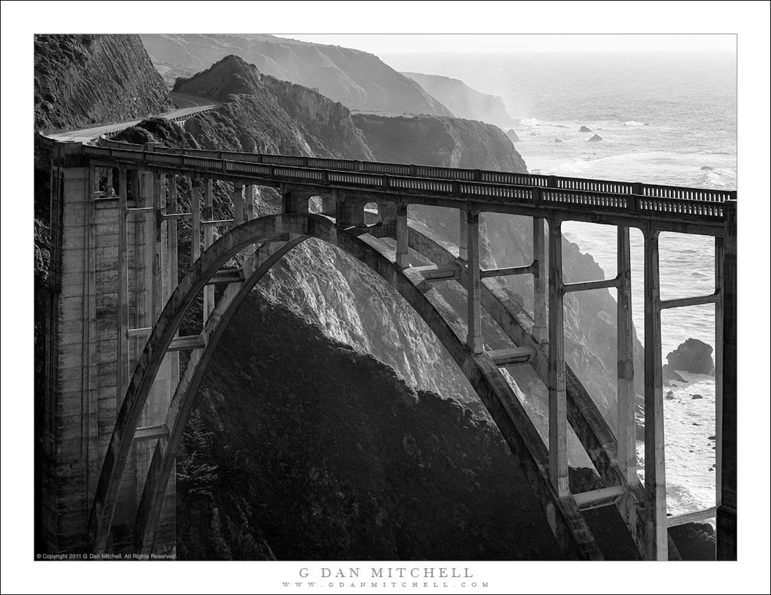
Bixby Bridge, Pacific Coast Highway. © Copyright 2022 G Dan Mitchell.

The Pacific Coast Highway crossing Bixby Bridge above the rugged Big Sur coastline of California.

Bixby Bridge is one of the iconic sights along the rugged terrain of California Coast Highway (highway one) in the Big Sur area south of Monterey. Although it is not the only bridge of its type along this route – and, in my opinion, not necessarily the most visually impressive – it is no doubt the best known. Many people drive to this spot and stop to take in the view from high above the ocean and to photograph the bridge and this scenic section of the highway.

I have photographed this bridge before, and I’ve spent a bit of time scoping out alternative points of view. These include some locations visible from “behind” the bridge, up higher in the coastal hills, and from other nearby locations along the highway. While I have photographed the bridge from the backside in the past, the idea of photographing it in black and white from this vantage point was triggered by a photograph by Chris Morrison that I saw in an online photography forum. When I saw it, I almost immediately “saw” a slightly different composition of the bridge and the steep headlands and cliffs running south along the coast.


G Dan Mitchell is a California photographer and visual opportunist. His book, “California’s Fall Color: A Photographer’s Guide to Autumn in the Sierra” is available from Heyday Books, Amazon, and directly from G Dan Mitchell.

Blog | About | Twitter | Flickr | FacebookEmail

Links to Articles, Sales and Licensing, my Sierra Nevada Fall Color book, Contact Information.

Scroll down to leave a comment or question. (Click this post’s title first if you are viewing on the home page.)


All media © Copyright G Dan Mitchell and others as indicated. Any use requires advance permission from G Dan Mitchell.

Golden Gate Bridge and Lunar Eclipse

Golden Gate Bridge and Lunar Eclipse

Golden Gate Bridge and Lunar Eclipse. San Francisco, California. December 10, 2011. © Copyright 2011 G Dan Mitchell – all rights reserved.

The moon, in full lunar eclipse, passes behind the south tower of the Golden Gate Bridge.

This is the second of two photographs of this week’s full lunar eclipse that I will share. The earlier one was a horizontal format version of roughly the same subject. Here the fully eclipsed setting moon passed behind the upper portion of the south tower of the Golden Gate Bridge, as seen from the San Francisco Bay shoreline in the Crissy Field area. There was just a bit of pre-dawn light in the sky at this point, and within a few minutes of making this photograph the combination of increasing ambient light, the generally hazy atmosphere, and the moon dropping into high, off-shore clouds brought the show to a fairly quick conclusion.

I was stunned by the number of other photographers out at this very early hour, even considering that it was within the city of San Francisco. I had originally tried Treasure Island, in the bay between San Francisco and Oakland. There were quite a few photographers lined up there at 5:00 a.m., but I did not like the potential positioning of the moon relative to likely foreground features near the horizon, so I didn’t stick around. Instead, I made a guess based on my knowledge of the area that there was a good chance that the moon might line up with the Golden Gate Bridge from vantage points in the Fort Mason, Crissy Field, and Fort Point areas. I drove over there quickly and was surprised to find the parking lots were nearly full and tripod-laden photographers walking about or already set up. I grabbed the first decent parking space, loaded up my gear, and started walking west, figuring that I could get to the likely spot on foot quite quickly.

A second surprise was that the ideal location, which wasn’t hard to find at all, was far less crowded than the areas closer to the parking lot. I was even able to find a spot or two where I could set up apart from other photographers and wait – for only a few moments by this time – for the moon to intersect with the bridge.

Another view of this subject in landscape orientation is posted here.

An interesting side note: Photographer Florian Kainz later shared his eclipse shot with me and asked if I might be the photographer standing in front of the bridge. Yes. That’s me! With Florian’s permission I have included a small version of his photo here – follow the links back to see his full-sized post at Flickr. He has given me permission to share his photograph here. Thanks, Florian!

Lunar Eclipse - just before Sunrise
Photograph © Copyright 2011 Florian Kainz. Used by permission of the photographer.

G Dan Mitchell is a California photographer whose subjects include the Pacific coast, redwood forests, central California oak/grasslands, the Sierra Nevada, California deserts, urban landscapes, night photography, and more.
Blog | About | Flickr | Twitter | FacebookGoogle+ | 500px.com | LinkedIn | Email

Text, photographs, and other media are © Copyright G Dan Mitchell (or others when indicated) and are not in the public domain and may not be used on websites, blogs, or in other media without advance permission from G Dan Mitchell.

Lunar Eclipse, Golden Gate Bridge

Lunar Eclipse, Golden Gate Bridge

Lunar Eclipse, Golden Gate Bridge. San Francisco, California. December 10, 2011. © Copyright 2011 G Dan Mitchell – all rights reserved.

Moon, in full lunar eclipse, drops behind the Golden Bridge South Tower, San Francisco, California.

Very (very!) early this morning I joined the surprisingly large throng of photographers out to shoot the lunar eclipse in the San Francisco area. I was up and out the door shortly after 4:00 a.m. and heading toward San Francisco. My first thought was to see if I could get an interesting composition with the moon over the San Francisco skyline by shooting from Treasure Island, in the bay between the City and Oakland. I arrived there while it was still very dark and found that lots of other photographers (and a motorcycle club!) were already on the scene. The photographers included to semi-astronomy types with the really, really big lenses and plenty of others.

The problem was immediately apparent. Even though the moon was still fairly high in the sky, it was apparent that it was going to set far to the right of San Francisco. I might have been able to find a workable spot on the island, but I still wasn’t sure the moon would be in a good spot once it got close to setting. At this point I decided to try a “plan B,” and I felt that there was a pretty good idea that I could make something work in the Crissy Field area. So I hopped back in the car, passed through downtown San Francisco, and arrived at the Crissy Field area…

… only to find out that I was most certainly not the only photographer thinking of using this location! There were hundreds of tripod-lugging photographers lined up a long the shoreline! My main idea at this point was to find a location from which the setting moon would pass above and then behind the bridge. So I headed off quickly towards the area where I thought this juxtaposition might be available. Soon I found it, and just as the sky was beginning to lighten up a bit and shedding a bit of natural light on the bridge. It was still quite challenging to get even a workable shot. The wind was blowing stiffly, making the necessary long exposures a bit tricky. In the end I think I got one or two that are interesting.

A vertical format version of this scene is posted here – I still haven’t decided which I prefer!

G Dan Mitchell is a California photographer whose subjects include the Pacific coast, redwood forests, central California oak/grasslands, the Sierra Nevada, California deserts, urban landscapes, night photography, and more.
Blog | About | Flickr | Twitter | FacebookGoogle+ | 500px.com | LinkedIn | Email

Text, photographs, and other media are © Copyright G Dan Mitchell (or others when indicated) and are not in the public domain and may not be used on websites, blogs, or in other media without advance permission from G Dan Mitchell.

Schoolhouse Ruins, Rhyolite

Schoolhouse Ruins, Rhyolite

Schoolhouse Ruins, Rhyolite. Rhyolite, Nevada. April 1, 2009 © Copyright 2009 G Dan Mitchell – all rights reserved.

Morning sunlight shine through the window frames of the ruins of the abandoned schoolhouse in the ghost town of Rhyolite Nevada, near Death Valley National Park.

The ghost town of Rhyolite, Nevada is located just east of the boundary of Death Valley National Park, along the edge of the Amargosa Valley, and not far from Beatty, Nevada, which itself is close to the Nevada Test Site. Put all of that together and you have the potential for a bit of a spooky place!

Rhyolite was a short-lived mining town in the early 1900s, when it apparently was home to thousands of people who streamed to this forsaken landscape to find silver. The town was eventually abandoned – although some mining still takes place in the area – but a good number of the larger buildings are still there, in various states of decay. An old train station that looks pretty fancy is fenced off to keep us out, but you can walk (respectfully and carefully!) among many other old structures including the old school house that is the subject of this photograph.

I’ve been out here a number of times and dawn is my favorite time to photograph here. The light makes it to many of the old ruins very shortly after actual sunrise, and there is a moment of often beautiful light at this time. From Rhyolite the hills inside Death Valley National Park are visible to the west and above the nearer hills you can see Telescope Peak, the highest point in the park at over 11,000′ elevation.

The school (like a few of the other ruins) looks like it must have been a very large and robust structure. Even though the roof and the second floor are gone, almost all of the exterior walls still stand and don’t show any immediate signs of incipient collapse. On this morning I made a series of photographs from just inside one of the “doorways” of the school with a wide-angle lens. I selected and shared a few of them back in 2009, but I recently went back to my original raw files and decided to try this one in black and white.

G Dan Mitchell Photography
About | Flickr | Twitter | FacebookGoogle+ | 500px.com | LinkedIn | Email

Text, photographs, and other media are © Copyright G Dan Mitchell (or others when indicated) and are not in the public domain and may not be used on websites, blogs, or in other media without advance permission from G Dan Mitchell.

(Basic EXIF data may be available by “mousing over” large images in posts when this page is viewed on the web. Leave a comment if you want to know more.)