Titus Canyon Road

Titus Canyon Road
Titus Canyon Road

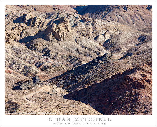
Titus Canyon Road. Death Valley National Park, California. December 11, 2013. © Copyright 2014 G Dan Mitchell – all rights reserved.

Titus Canyon Road descents into upper Titanothere Canyon before climbing to Red Pass

Early December is a fine time to be in Death Valley National Park, and I managed to spend five days there this past December. The weather is cooler this time of year – in fact, temperatures dropped into the upper twenties in the Valley during my visit and well down into the teens in some of the upper elevations that I visited during the pre-dawn hours. Although seasoned Death Valley visitors prefer to visit during the cooler months, things seem much quieter than a few months later in the spring. In fact, I almost had the entire Stovepipe Wells campground to myself on my first night!

The relative solitude extended to this day, on which I drove over the Amargosa Range via Titus Canyon Road, the rough back-country one-way route between the Amargosa Valley and Death Valley itself. I know this route fairly well, having been over it a number of times. I always start in the morning, and this trip was no exception – I was well out on to the route when the sun came up. Often I just take a few hours for the trip, stopping at a few key locations. But recently I have thought more about how I might photograph some of these places that I used to simply drive through, and on this visit I slowed way down and devoted almost the entire day to this area. The location in this photograph is an example of the sort of area that I might have just passed through in the past. Here the road traverses the upper reaches of a very large canyon that eventually spills out into Death Valley far below. The location from which I made the photograph marks the high point on the route, and I always stop there – but on some previous visits I have just regarded the terrain as being empty. It isn’t, and I’m learning to see it more clearly. Here the gravel road drops down from the previous ridge, winding through the rough and dry landscape to the bottom of the canyon and its dry stream bed before climbing steeply up to my camera position.

G Dan Mitchell is a California photographer and visual opportunist whose subjects include the Pacific coast, redwood forests, central California oak/grasslands, the Sierra Nevada, California deserts, urban landscapes, night photography, and more.
Blog | About | Flickr | Twitter | FacebookGoogle+ | 500px.com | LinkedIn | Email

Text, photographs, and other media are © Copyright G Dan Mitchell (or others when indicated) and are not in the public domain and may not be used on websites, blogs, or in other media without advance permission from G Dan Mitchell.

Alpine Trees, Last Light

Alpine Trees, Last Light

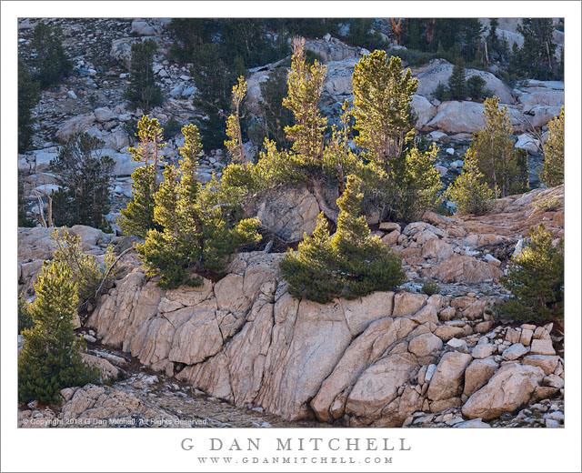
Alpine Trees, Last Light. Kings Canyon National Park, California. September 17, 2013. © Copyright 2014 G Dan Mitchell – all rights reserved.

Late afternoon light on small alpine trees growing in glaciated terrain, Kings Canyon National Park

This is a photograph from the latter portion of our nine-day photographic trip into the eastern High Sierra of Kings Canyon National Park last September. By the time I made this photograph I had been on the trail about a week, and we were nearing the end of our lengthy stay at our 11,000′ campground in the backcountry of Kings Canyon National Park. All such trips transition through a series of phases, and at this point I was in a phase of feeling more and more comfortable and familiar with these surroundings that we had explored so carefully – but I was also beginning to recognize that the end of this trip was not too far off.

Late on this afternoon I did one of my by-now-customary walks up the small, lake-filled valley ascending to the south from our camp. Because of very high ridges to our west, the sun was blocked from the valley terrain somewhat early in the day – late afternoon rather than evening. I reached the upper valley while there was still sun, but almost immediately the sun/shadow border began to move down into the valley and across the trees, rocks, and lake. I made a point of following this boundary, where the light can be at its most interesting at this time of day. Consequently I was moving almost constantly, generally moving west and north across and down the valley. In many cases I had only a brief moment to photograph whatever was being struck by the light at the edge of the moving shadow, so I was working each opportunity rather quickly. When I made this photograph the light had left the background talus fields and was still just striking this row of trees on top of a granite bench next to a small lake.

G Dan Mitchell is a California photographer and visual opportunist whose subjects include the Pacific coast, redwood forests, central California oak/grasslands, the Sierra Nevada, California deserts, urban landscapes, night photography, and more.
Blog | About | Flickr | Twitter | FacebookGoogle+ | 500px.com | LinkedIn | Email

Text, photographs, and other media are © Copyright G Dan Mitchell (or others when indicated) and are not in the public domain and may not be used on websites, blogs, or in other media without advance permission from G Dan Mitchell.
Snag and Talus Field

Snag and Talus Field

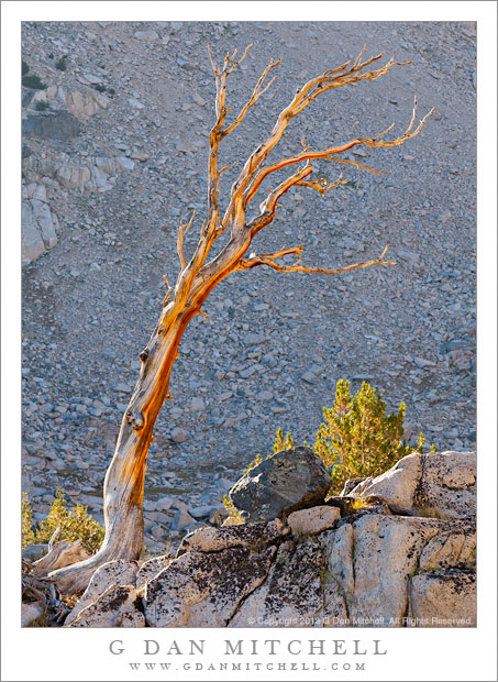
Snag and Talus Field. Kings Canyon National Park, California. September 16, 2013. © Copyright 2014 G Dan Mitchell – all rights reserved.

An old snag stands atop a rocky outcropping and in front of a huge talus field, Kings Canyon National Park

During our mid-September 9-day expedition into the Sierra Nevada high country of Kings Canyon National Park we spent the better part of a week camped in this 11,000′ basin full of lakes and trees and rocks. We camped near the outlet stream of a lake located in a narrow section of the valley, with many more lakes beyond our location and a string of them ascending the valley to our south. Each day, from early morning until after dark, was largely spent exploring this landscape and making photographs.

The valley of lakes to our south, of which our lake was the lowest, was plainly visible to us from our camp site, which was situated on a rise above this lowest lake. From here we could look up the canyon across “our lake” and see a string of several other lakes along this creek. A few were easy to see while others further up the valley revealed themselves primarily by surrounding rock and by breaks in the vegetation. Every day, no matter what else we were doing and where else we photographed, we did at least some work around these closest lakes, and I developed a sort of “daily rounds” taking me up one side of the valley to the upper lake and then back down the other, with occasional detours across the middle of the valley. Is I recall, I was making one of those detours when I photographed this tree, located on top of a small rocky knoll in the middle of the upper valley and backed by the tremendous talus field descending from the surrounding ridges high above.

G Dan Mitchell is a California photographer and visual opportunist whose subjects include the Pacific coast, redwood forests, central California oak/grasslands, the Sierra Nevada, California deserts, urban landscapes, night photography, and more.
Blog | About | Flickr | Twitter | FacebookGoogle+ | 500px.com | LinkedIn | Email

Text, photographs, and other media are © Copyright G Dan Mitchell (or others when indicated) and are not in the public domain and may not be used on websites, blogs, or in other media without advance permission from G Dan Mitchell.
Sea Stacks, Big Sur Coastline

Sea Stacks, Big Sur Coastline

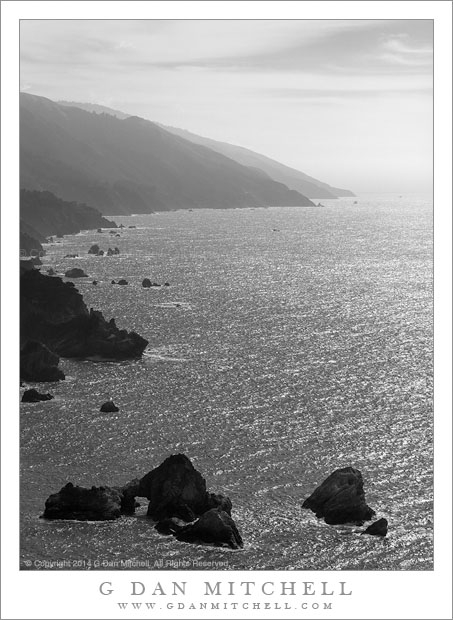
Sea Stacks, Big Sur Coastline. Pacific Coast Highway, California. January 31, 2014. © Copyright 2014 G Dan Mitchell – all rights reserved.

The receding ridges of the Big Sur coastline arc southward into winter haze beyond a pair of large sea stacks.

On the final day of January we did the “down and back” drive through the Big Sur area of California’s Pacific Coast Highway. This is my favorite time of year in this part of California. At one point along the drive I made a comment (as I often do while passing through here at this time of year) about how this weather felt more like a “typical summer day” than like a “typical winter day” – and then I quickly caught myself and recalled that “typical summer days” here often feature thick fog, wind, and cold. On the other hand, between Pacific storms – or during a dry year like this one – a typical winter day may feature brilliant sunshine and long vistas and temperatures that are as warm as those of summer here.

As the day developed I shifted from looking for the effects of first and early light coming over ridges and into canyons, or the thinning offshore clouds. Instead I started to think about the long coastal vistas, the intense reflection of the ocean seen from high places (which always makes me think of molten metal), and the way that the backlit atmosphere highlights receding ridges as they disappear into the distance. As we came over one of the high points and around the corner the road began to drop and this view appeared in front of us, with two sea stacks in the foreground (one of which contains a natural arch) and the rugged coastline curving toward the south.

G Dan Mitchell is a California photographer and visual opportunist whose subjects include the Pacific coast, redwood forests, central California oak/grasslands, the Sierra Nevada, California deserts, urban landscapes, night photography, and more.
Blog | About | Flickr | Twitter | FacebookGoogle+ | 500px.com | LinkedIn | Email

Text, photographs, and other media are © Copyright G Dan Mitchell (or others when indicated) and are not in the public domain and may not be used on websites, blogs, or in other media without advance permission from G Dan Mitchell.

Photographer and visual opportunist. Daily photos since 2005, plus articles, reviews, news, and ideas.