
Tag Archives: rocky

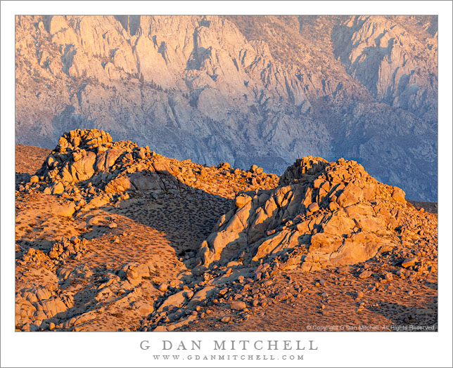
Buttermilk Range, Morning

Buttermilk Range, Morning

Buttermilk Range, Morning. Near Bishop, California. October 15, 2011. © Copyright 2011 G Dan Mitchell – all rights reserved.

Early morning light strikes a ridge in the Buttermilk Range, with the eastern escarpment of the Sierra Nevada in the background.

While in the eastern Sierra last week to photograph aspen color again, I detoured away from the trees at sunrise one morning to photograph the first light striking these hills in the Buttermilk Range above Bishop, California, with a steep section of the Sierra’s east escarpment beyond. The light in this area is often spectacular in the early morning, but it can be especially so when there are some clouds in the sky as was the case on this morning. While it was almost completely clear to the west over the Sierra crest, the sky to the east held some broken clouds which cast alternating patterns of light and shadow across the landscape. Here, while the light on the foreground rocky ridge was very intense and saturated, some haze muted the more distant ridge and the shadow from those clouds slightly obscured the lower slopes.

The Buttermilks are yet another example of the range to subjects to be found in the eastern Sierra. Sometimes I head to these mountains with a plan of shooting a particular subject or even a particular place, but this doesn’t always work out. The weather may change or my schedule may change. Fortunately, if the original subject doesn’t work, there are almost always other choices! This small range tucked up against the Sierra above Bishop – like many other similar places along the “east side” – contains a wealth of photographic subjects to explore.

G Dan Mitchell Photography
About | Flickr | Twitter | FacebookGoogle+ | 500px.com | LinkedIn | Email

Text, photographs, and other media are © Copyright G Dan Mitchell (or others when indicated) and are not in the public domain and may not be used on websites, blogs, or in other media without advance permission from G Dan Mitchell.
(Basic EXIF data may be available by “mousing over” large images in posts when this page is viewed on the web. Leave a comment if you want to know more.)

Flooded Meadow Near Greenstone Lake

Flooded Meadow Near Greenstone Lake

Flooded Meadow Near Greenstone Lake. Sierra Nevada, California. August 11, 2011. © Copyright 2011 G Dan Mitchell – all rights reserved.

Late-season snow fields are reflected in the pond of a flooded alpine meadow near Greenstone Lake, Sierra Nevada.

During this year of heavy and late winter snowfall, there is still a surprising amount of snow in the Sierra Nevada high country. In the upper portion of this image you can see large snow fields (with much larger ones higher on the slope and out of the frame) at that base of this talus slope at around 10,000+ feet of elevation. During a more typical year, there would still be a few scattered snow fields, but nothing like we see this year. And because there is still so much snow, the plants that would normally be well-developed by now are still just emerging, and the creeks and ponds are overflowing, the meadows are flooded… and the mosquitos are having a field day!

This little pond among the boulder-filled meadows near Greenstone Lake at the far end of Saddlebag Lake was still overflowing with snowmelt water that reflected the extensive snow fields still on the talus field beyond. To get to this spot – in mid-August! – I had to cross a number of still frozen snow fields, follow trails that were flooded in places, and pick my way carefully across waterlogged meadows. It is going to be a short summer season in the high Sierra, but as a compensatory bonus we may still see wildflowers all the way into September.

G Dan Mitchell Photography
About | Flickr | Twitter | FacebookGoogle+ | 500px.com | LinkedIn | Email

Text, photographs, and other media are © Copyright G Dan Mitchell (or others when indicated) and are not in the public domain and may not be used on websites, blogs, or in other media without advance permission from G Dan Mitchell.
(Basic EXIF data may be available by “mousing over” large images in posts. Leave a comment if you want to know more.)

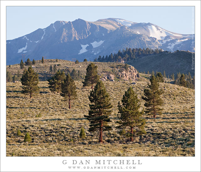
Eastern Sierra Nevada Near June Lake

Eastern Sierra Nevada Near June Lake

Eastern Sierra Nevada Near June Lake. Mono County, California. August 10, 2011. © Copyright 2011 G Dan Mitchell – all rights reserved.

Trees ascend sage-covered hills toward the Sierra Nevada crest near June Lake, California.

Near highway 395 in Mono County, the main north-south route east of the Sierra crest, these open stands of large conifers ascend from the high desert sagebrush country towards the peaks of the Sierra crest, which rise much more abruptly on this side of the range than on the gentle west side. The tall ridge is above the June Lakes resort area between Mammoth Lakes and Lee Vining.

While my primary goal on this trip was to photograph in the Yosemite high country along Tioga Pass Road, smoke from a wildfire near Glacier Point in the park was drifting over the Tuolumne area and creating a lot of very non-photogenic haze. I had a hunch that by dropped over to the east side of the range I might be able to get away from the smoke or at least find areas where it wasn’t so thick. The smoke was still affecting the light near Lee Vining, but I didn’t have to drive too far south to get out of its path, though even here there is a bit of haze increasing the effect of atmospheric recession.

G Dan Mitchell Photography
About | Flickr | Twitter | FacebookGoogle+ | 500px.com | LinkedIn | Email

Text, photographs, and other media are © Copyright G Dan Mitchell (or others when indicated) and are not in the public domain and may not be used on websites, blogs, or in other media without advance permission from G Dan Mitchell.

(Basic EXIF data may be available by “mousing over” large images in posts. Leave a comment if you want to know more.)

Big Sur Coastline Near Soberanes Creek, Spring

Big Sur Coastline Near Soberanes Creek, Spring

Big Sur Coastline Near Soberanes Creek, Spring. California Coast. May 13, 2011. © Copyright G Dan Mitchell – all rights reserved.

A sunny spring morning along the Big Sur Coast at Soberanes Creek, with fog above the coastal mountains.

This is a spot that is probably familiar to many who have driven down this section of the Big Sur coastline south of Monterey and Carmel, California. To the right, and out of the photograph, is Soberanes Canyon which ascends steeply toward the ridges above Pacific Ocean. A creek flows down the canyon, underneath the coast highway, and then into the ocean.

The foreground bluff looks inviting with its green color and spring flowers. However, I picked up one of the worst cases of poison oak I’ve had on one occasion when I walked across this meadow to photograph the sea stacks and coastline at dusk!

G Dan Mitchell Photography | Flickr | Twitter (follow me) | Facebook (“Like” my page) | LinkedIn | Email
Text, photographs, and other media are © Copyright G Dan Mitchell (or others when indicated) and are not in the public domain and may not be used on websites, blogs, or in other media without advance permission from G Dan Mitchell.