
Tag Archives: sky

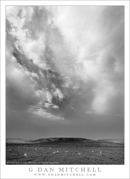
Dust Storm, Death Valley

Dust Storm, Death Valley

Dust Storm, Death Valley. Death Valley National Park, California. April 3, 2009 © Copyright 2009 G Dan Mitchell – all rights reserved.

A building dust storm begins to obscure the sky above Death Valley, California.

In retrospect, there were hints that this tremendous dust storm was coming prior to its actual arrival. Very early in the morning I had been photographing at another location and the light and atmosphere were a bit unusual. The dawn and very early morning light was beautifully warm, but the distant peaks were slightly obscured by a sort of atmospheric haze that is hard to describe but which I now recognize as being associated with incoming dust storms. Soon, large and impressive clouds began to appear high in the deep blue sky, but at about the same time the air closer to the bottom of Death Valley started to look increasingly opaque.

I left my early morning shooting location and began my trip home from Death Valley. After a stop at Furnace Creek – to treat myself to a real breakfast after days of camping – I headed north towards Stovepipe Wells. As I headed north I began to see the obvious clouds of blowing dust accumulating along the Grapevine Mountains, and shortly before the turn to Stovepipe I encountered the boundary between the relatively clear air and the murk of the dust storm that was growing directly ahead and off to my left.

Before entering the cloud – I had not choice since my route went that direction – I pulled over within perhaps a quarter-mile of the edge of the storm. Not wanting to risk dust getting into my camera, I unpacked my gear inside the car and decided to just use the lens that was already fitted to the camera. I stepped outside to find that lines of wind-blown dust were already streaming along the ground and that the atmosphere had taken on the strange and electric feel of these storms. Off to my left, the dust was beginning to kick up among some low, dark hills across a nearby wash, while a gap in the dust clouds momentarily left open a window to the bright sky and high clouds above.

Related: See my posts on Photographing Death Valley

G Dan Mitchell is a California photographer whose subjects include the Pacific coast, redwood forests, central California oak/grasslands, the Sierra Nevada, California deserts, urban landscapes, night photography, and more.
Blog | About | Flickr | Twitter | FacebookGoogle+ | 500px.com | LinkedIn | Email

Text, photographs, and other media are © Copyright G Dan Mitchell (or others when indicated) and are not in the public domain and may not be used on websites, blogs, or in other media without advance permission from G Dan Mitchell.

From the Panamints to the Sierra

From the Panamints to the Sierra

From the Panamints to the Sierra. Death Valley National Park, California. April 1, 2009. © Copyright 2009 G Dan Mitchell – all rights reserved.

A landscape of high desert ridges and mountain ranges extends from Death Valley’s Panamint Range to the peaks of the southern Sierra Nevada in late afternoon light.

This lookout, high in the Panamint Range at the end of a gravel road, is one of my favorite places to be at the end of the day in Death Valley National Park. Perhaps because it is a bit less well-known, because it has a name that is harder to pronounce and remember than “Dantes View,” due to its location at the end of this gravel road which at one point passes along a very exposed section of the ridge, and because it is farther from some of the popular places to stay in the park the number of visitors here remains small. I frequently have the place completely to myself or perhaps share it with one or two others.

Behind the camera position is a stupendous view down into Death Valley itself, many thousands of feet below. But in the other direction, looking back towards the west, a series of rugged high desert valleys and mountain ranges extends all the way to the highest peaks of the southern Sierra Nevada range. In the morning, the front light can show the details of snow and rock on the summit of the Sierra, but in the evening the light crossing the intermediate ridges picks up late-afternoon haze and mutes the details of the scene.

G Dan Mitchell is a California photographer whose subjects include the Pacific coast, redwood forests, central California oak/grasslands, the Sierra Nevada, California deserts, urban landscapes, night photography, and more.
Blog | About | Flickr | Twitter | FacebookGoogle+ | 500px.com | LinkedIn | Email

Text, photographs, and other media are © Copyright G Dan Mitchell (or others when indicated) and are not in the public domain and may not be used on websites, blogs, or in other media without advance permission from G Dan Mitchell.
Frozen Pond and Sierra Nevada Range, Owens Valley

Frozen Pond and Sierra Nevada Range, Owens Valley

Frozen Pond and Sierra Nevada Range, Owens Valley. Long Valley Area, California. October 9, 2011. © Copyright 2011 G Dan Mitchell – all rights reserved.

The snow-dusted eastern escarpment of the Sierra Nevada reflected in the surface of a frozen pond on the high desert of Owens Valley, California.

On a very cold early October morning this year I ended up driving out into Owens Valley toward the Owens River after I spotted some interesting morning fog while driving out of Mammoth Lakes on highway 395. Although I had started out with the intention of photographing aspens, when I saw the fog I changed my plans and decided to leave the aspen photography for later. I first drove to a small lake where I have photographed several times in the past, a lake that provides very still water at sunrise and great reflections of the peaks of the Sierra crest which were covered with the snow from a series of early season storms.

After sunrise I decided that I was finished at that lake, so I got back in the vehicle and went exploring on some gravel roads that wander around in the general area of Hot Creek and Owens River. At first I aimed for some ground fog-covered areas that I had spotted earlier, and for a section of creek where the warm water seems to frequently create interesting fog on cold mornings. I arrived at this creek, took a look around, and decided that it wasn’t quite what I wanted to photograph, so I kept driving, ending up on some roads I had not visited before. As I crossed one long flat area of rangeland I passed this mall frozen pond, drove a bit further, and then turned around to come back and photograph it with the early morning – but no longer dawn – like on the snow-covered peaks just south of Mammoth.

G Dan Mitchell is a California photographer whose subjects include the Pacific coast, redwood forests, central California oak/grasslands, the Sierra Nevada, California deserts, urban landscapes, night photography, and more.
Blog | About | Flickr | Twitter | FacebookGoogle+ | 500px.com | LinkedIn | Email

Text, photographs, and other media are © Copyright G Dan Mitchell (or others when indicated) and are not in the public domain and may not be used on websites, blogs, or in other media without advance permission from G Dan Mitchell.

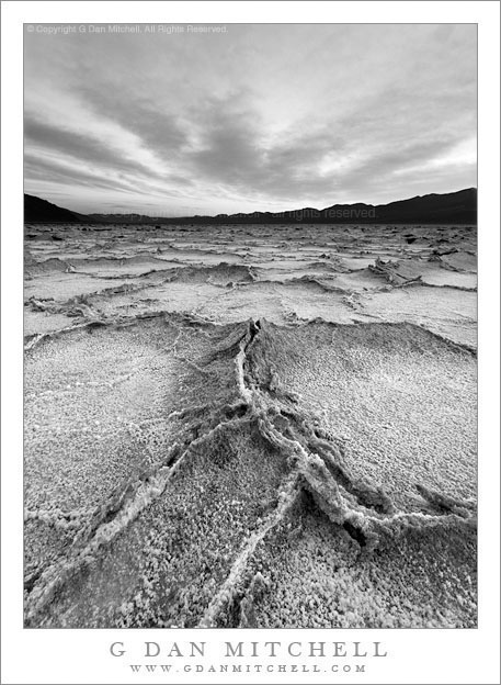
Badwater Salt Flats, Evening

Badwater Salt Flats, Evening

Badwater Salt Flats, Evening. Death Valley National Park, California. March 31, 2009. © Copyright 2009 G Dan Mitchell – all rights reserved.

Black and white photograph of rough patterns in the dried salt desert floor at Badwater Salt Flats, Death Valley National Park.

This is another of the “rediscovered photographs” that I uncovered while reviewing many years of raw files recently. Periodically I go through all of the old archived raw files, partly to cull out a few that I know that I’ll never use, but also because I know that whenever I revisit the old files I discover some photographs that I had forgotten or had never understood at the time I made them. Revisiting the old file archives, I’m sometimes shocked that I passed over certain images.

This one is from the salt flats at Badwater in Death Valley National Park. Technically, this was not shot at precisely “Badwater,” but it is close enough. I was out on the flats in the late afternoon, shooting as the sun dropped behind the Panamint Range. In my view, the best light – with the exception of days when clouds might tower above the Panamints – comes starting right about at the time that the sun passes the line of the ridge as it descends at the end of the day. This takes the incredibly bright and harsh sun off of the playa and provides softer light in the shadow of the range. However, this also presents a problem that almost everyone who has shot here must understand, namely that the illumination by the bright blue sky turns the “white” salt a surprisingly intense blue color. I’ve seen people handle this in a variety of ways: keep the intense, almost gaudy, blue color; do a lot of color correction to get colors that more closely correspond to what we recall seeing; mostly include the sky with its more intense colors; or let the colors go and do a black and white rendition.

Although I’ve “done” this subject in color a number of times, somehow this one seemed to call out for black and white. For one thing, it allowed me to use the interesting shapes of the evening clouds as a dramatic backdrop to the rough and broken shapes of the playa salt polygons. It also allowed me to try an interpretation that focuses on the dramatic potential of the scene.

G Dan Mitchell is a California photographer whose subjects include the Pacific coast, redwood forests, central California oak/grasslands, the Sierra Nevada, California deserts, urban landscapes, night photography, and more.
Blog | About | Flickr | Twitter | FacebookGoogle+ | 500px.com | LinkedIn | Email

Text, photographs, and other media are © Copyright G Dan Mitchell (or others when indicated) and are not in the public domain and may not be used on websites, blogs, or in other media without advance permission from G Dan Mitchell.