
Tag Archives: sky

Sierra Wave Clouds Above Owens Valley, Dawn

“Sierra Wave Clouds Above Owens Valley, Dawn”— Sierra wave clouds building at dawn are reflected in the waters of an Owens Valley lake.

On this morning I was up well before dawn – I checked out of my motel in Bishop, California and was on the road while it was still dark, with a semi-plan of photographing aspen trees around dawn up in the northern portion of the June Lakes Loop. As I headed north out of Bishop and through Round Valley, the very first light arrived and I saw the dim outlines of Sierra wave clouds forming over and just east of the crest. Now, this was an interesting development!

As I continued north and the light increased, the clouds began to interest me more than the possibility of photographing more aspens – I could do that later, but such clouds are unpredictable and transitory. I could see that subtle color was beginning to appear along the edges of the clouds even though it was not yet sunrise, and I decided that I needed to find some landscape feature – almost any would do! – that could serve as a foil to these clouds so that I could photograph them as they began to pick up sunrise color.

A week earlier I had photographed at some small lakes out in Owens Valley, and it occurred to me that if I could get there in time that they might reflect the clouds nicely, though I was a bit concerned about how the lake and the mountains and the clouds would actually align. But not having any better ideas and having very little time, I decided to make the lake my goal and without much further thought took the turnoff, parked my car near the largest lake, grabbed my gear, and headed across the sage brush landscape to the shore of the lake. My initial thought that I might be able to include the Sierra range in the image with the clouds clearly wasn’t going to work due to their relative positions, so I circled a bit further around the shore of the lake and instead composed a scene that excluded all but the tiniest bit of the peaks of the Sierra.

G Dan Mitchell Photography
About | Flickr | Twitter | FacebookGoogle+ | 500px.com | LinkedIn | Email

Text, photographs, and other media are © Copyright G Dan Mitchell (or others when indicated) and are not in the public domain and may not be used on websites, blogs, or in other media without advance permission from G Dan Mitchell.

(Basic EXIF data may be available by “mousing over” large images in posts when this page is viewed on the web. Leave a comment if you want to know more.)
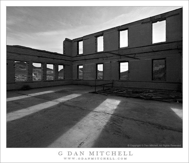
Schoolhouse Ruins, Rhyolite

Schoolhouse Ruins, Rhyolite

Schoolhouse Ruins, Rhyolite. Rhyolite, Nevada. April 1, 2009 © Copyright 2009 G Dan Mitchell – all rights reserved.

Morning sunlight shine through the window frames of the ruins of the abandoned schoolhouse in the ghost town of Rhyolite Nevada, near Death Valley National Park.

The ghost town of Rhyolite, Nevada is located just east of the boundary of Death Valley National Park, along the edge of the Amargosa Valley, and not far from Beatty, Nevada, which itself is close to the Nevada Test Site. Put all of that together and you have the potential for a bit of a spooky place!

Rhyolite was a short-lived mining town in the early 1900s, when it apparently was home to thousands of people who streamed to this forsaken landscape to find silver. The town was eventually abandoned – although some mining still takes place in the area – but a good number of the larger buildings are still there, in various states of decay. An old train station that looks pretty fancy is fenced off to keep us out, but you can walk (respectfully and carefully!) among many other old structures including the old school house that is the subject of this photograph.

I’ve been out here a number of times and dawn is my favorite time to photograph here. The light makes it to many of the old ruins very shortly after actual sunrise, and there is a moment of often beautiful light at this time. From Rhyolite the hills inside Death Valley National Park are visible to the west and above the nearer hills you can see Telescope Peak, the highest point in the park at over 11,000′ elevation.

The school (like a few of the other ruins) looks like it must have been a very large and robust structure. Even though the roof and the second floor are gone, almost all of the exterior walls still stand and don’t show any immediate signs of incipient collapse. On this morning I made a series of photographs from just inside one of the “doorways” of the school with a wide-angle lens. I selected and shared a few of them back in 2009, but I recently went back to my original raw files and decided to try this one in black and white.

G Dan Mitchell Photography
About | Flickr | Twitter | FacebookGoogle+ | 500px.com | LinkedIn | Email

Text, photographs, and other media are © Copyright G Dan Mitchell (or others when indicated) and are not in the public domain and may not be used on websites, blogs, or in other media without advance permission from G Dan Mitchell.

(Basic EXIF data may be available by “mousing over” large images in posts when this page is viewed on the web. Leave a comment if you want to know more.)
Seagulls, Night Sky

Seagulls, Night Sky
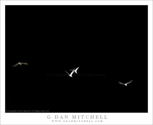
Seagulls, Night Sky

Seagulls, Night Sky. San Francisco, California. September 7, 2007. © Copyright 2007 G Dan Mitchell – all rights reserved.

Seagulls fly through artificial lighting at night, San Francisco, California.

I wouldn’t mind if you speculated about how in the world I managed to get this king of lighting on a photograph of birds in flight. Let’s see, it couldn’t be on-camera flash since the light is coming from the side. Perhaps I concocted some elaborate multiple flash setup and then waited for the birds?

I’m afraid that the explanation is much more prosaic. To be honest, we were at a San Francisco Giants game on this evening. We go to Giants games for several reasons: the hope that the Giants might actually play well (not at the moment!), the great views from AT&T park, garlic fries (!)… and for me, photography. I always bring a camera and a lens, and partway through the game I usually take advantage of the upper areas of the stadium to photograph San Francisco and the Bay, often at sunset and dusk.

One more fact. Giants fans who attend games have discovered something astonishing about wildlife, namely that the sea gulls seem to be able to tell when it is the seventh inning or so. At about this point in the game, flocks of them begin to assemble over the park, circling above the field and the stands… and waiting for their chance to feast on the discarded food that is left all over the stadium. (My working theory is that they have somehow learned to associate a full stadium with the appearance of good stuff to eat about two or three hours later. They are apparently as fond of garlic fries as we are.)

So, on this evening when the gulls showed up they began to fly in and out of the stadium lighting, creating a somewhat stark and dramatic effect against the dark sky.

G Dan Mitchell Photography
About | Flickr | Twitter | FacebookGoogle+ | 500px.com | LinkedIn | Email

Text, photographs, and other media are © Copyright G Dan Mitchell (or others when indicated) and are not in the public domain and may not be used on websites, blogs, or in other media without advance permission from G Dan Mitchell.

(Basic EXIF data may be available by “mousing over” large images in posts when this page is viewed on the web. Leave a comment if you want to know more.)

Old Brick Building and Remnants of the High Line

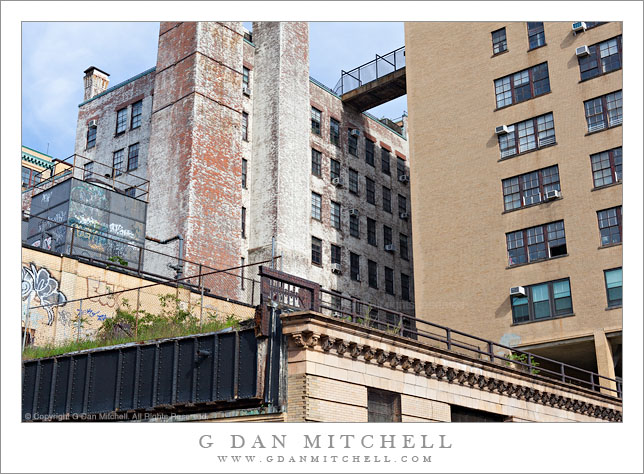
Old Brick Building and Remnants of the High Line

Old Brick Building and Remnants of the High Line. New York, New York. August 24, 2011. © Copyright 2011 G Dan Mitchell – all rights reserved.

Remnants of the old right-of-way of the High Line Railway run in front of and old and run-down brick building, New York City.

There is, no doubt, a lot of history in this scene that I’m unaware of – but the visual elements mostly caught my attention as we walked past this spot. On the final morning of our August 2011 visit to New York, we were walking from West Village to Chelsea when we passed this area. My son, who lives in Brooklyn and is obsessed (in the good way!) with walking around lots of areas of New York City and making photographs and noting what he sees, first pointed out the terrace in the lower part of the scene (bounded by the railing) and the steel structure at the lower left. He told me that this was part of the High Line Railroad that used to run through this part of Manhattan. A more famous section of the High Line has become a very popular “elevated park” in Chelsea, but in this area it is pretty much just abandoned and, in places, gone.

I don’t know what the tall and worn-looking brick building is, but I’d sure like to know. My hunch, given the appearance of a former white paint job and the proximity to the railroad tracks, is that it must have been some sort of industrial building at some point.

G Dan Mitchell Photography
About | Flickr | Twitter | FacebookGoogle+ | 500px.com | LinkedIn | Email

Text, photographs, and other media are © Copyright G Dan Mitchell (or others when indicated) and are not in the public domain and may not be used on websites, blogs, or in other media without advance permission from G Dan Mitchell.

(Basic EXIF data may be available by “mousing over” large images in posts when this page is viewed on the web. Leave a comment if you want to know more.)