
Tag Archives: clouds

Sierra Wave Clouds Above Owens Valley, Dawn

“Sierra Wave Clouds Above Owens Valley, Dawn”— Sierra wave clouds building at dawn are reflected in the waters of an Owens Valley lake.

On this morning I was up well before dawn – I checked out of my motel in Bishop, California and was on the road while it was still dark, with a semi-plan of photographing aspen trees around dawn up in the northern portion of the June Lakes Loop. As I headed north out of Bishop and through Round Valley, the very first light arrived and I saw the dim outlines of Sierra wave clouds forming over and just east of the crest. Now, this was an interesting development!

As I continued north and the light increased, the clouds began to interest me more than the possibility of photographing more aspens – I could do that later, but such clouds are unpredictable and transitory. I could see that subtle color was beginning to appear along the edges of the clouds even though it was not yet sunrise, and I decided that I needed to find some landscape feature – almost any would do! – that could serve as a foil to these clouds so that I could photograph them as they began to pick up sunrise color.

A week earlier I had photographed at some small lakes out in Owens Valley, and it occurred to me that if I could get there in time that they might reflect the clouds nicely, though I was a bit concerned about how the lake and the mountains and the clouds would actually align. But not having any better ideas and having very little time, I decided to make the lake my goal and without much further thought took the turnoff, parked my car near the largest lake, grabbed my gear, and headed across the sage brush landscape to the shore of the lake. My initial thought that I might be able to include the Sierra range in the image with the clouds clearly wasn’t going to work due to their relative positions, so I circled a bit further around the shore of the lake and instead composed a scene that excluded all but the tiniest bit of the peaks of the Sierra.

G Dan Mitchell Photography
About | Flickr | Twitter | FacebookGoogle+ | 500px.com | LinkedIn | Email

Text, photographs, and other media are © Copyright G Dan Mitchell (or others when indicated) and are not in the public domain and may not be used on websites, blogs, or in other media without advance permission from G Dan Mitchell.

(Basic EXIF data may be available by “mousing over” large images in posts when this page is viewed on the web. Leave a comment if you want to know more.)
Schoolhouse Ruins, Rhyolite

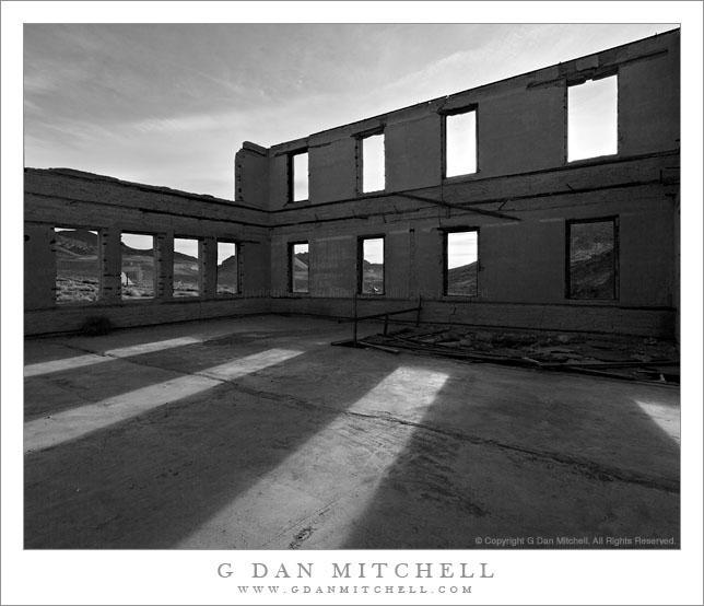
Schoolhouse Ruins, Rhyolite

Schoolhouse Ruins, Rhyolite. Rhyolite, Nevada. April 1, 2009 © Copyright 2009 G Dan Mitchell – all rights reserved.

Morning sunlight shine through the window frames of the ruins of the abandoned schoolhouse in the ghost town of Rhyolite Nevada, near Death Valley National Park.

The ghost town of Rhyolite, Nevada is located just east of the boundary of Death Valley National Park, along the edge of the Amargosa Valley, and not far from Beatty, Nevada, which itself is close to the Nevada Test Site. Put all of that together and you have the potential for a bit of a spooky place!

Rhyolite was a short-lived mining town in the early 1900s, when it apparently was home to thousands of people who streamed to this forsaken landscape to find silver. The town was eventually abandoned – although some mining still takes place in the area – but a good number of the larger buildings are still there, in various states of decay. An old train station that looks pretty fancy is fenced off to keep us out, but you can walk (respectfully and carefully!) among many other old structures including the old school house that is the subject of this photograph.

I’ve been out here a number of times and dawn is my favorite time to photograph here. The light makes it to many of the old ruins very shortly after actual sunrise, and there is a moment of often beautiful light at this time. From Rhyolite the hills inside Death Valley National Park are visible to the west and above the nearer hills you can see Telescope Peak, the highest point in the park at over 11,000′ elevation.

The school (like a few of the other ruins) looks like it must have been a very large and robust structure. Even though the roof and the second floor are gone, almost all of the exterior walls still stand and don’t show any immediate signs of incipient collapse. On this morning I made a series of photographs from just inside one of the “doorways” of the school with a wide-angle lens. I selected and shared a few of them back in 2009, but I recently went back to my original raw files and decided to try this one in black and white.

G Dan Mitchell Photography
About | Flickr | Twitter | FacebookGoogle+ | 500px.com | LinkedIn | Email

Text, photographs, and other media are © Copyright G Dan Mitchell (or others when indicated) and are not in the public domain and may not be used on websites, blogs, or in other media without advance permission from G Dan Mitchell.

(Basic EXIF data may be available by “mousing over” large images in posts when this page is viewed on the web. Leave a comment if you want to know more.)
Sunset, Lower McCabe Lake, Shepherds Crest, and Virginia Canyon

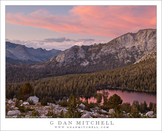
Sunset, Lower McCabe Lake, Shepherds Crest, and Virginia Canyon

Sunset, Lower McCabe Lake, Shepherds Crest, and Virginia Canyon. Yosemite National Park, California. September 19, 2011. © Copyright 2011 G Dan Mitchell – all rights reserved.

Afternoon storm clouds clear from the sunset sky above Lower McCabe Lake, Shepherds Crest, and Virginia Canyon, Yosemite National Park.

With this photograph I get to tell another of the “serendipitous photograph” stories that seem to keep coming up in my work. In this case, we had been camped near the lake in the lower area of the photograph for several days, getting to know the place and having time to carefully photograph various areas nearby. On a previous evening we had climbed to a second lake a few hundred feet higher than the “main” lake, from which one of our group decided to traverse a nearby slope. He ended up at another alpine lake that looked interesting, and the next morning others went with him to visit it. I didn’t, because I had some other things that I wanted to photograph in morning light and because I had a hunch that the light might turn out to be more interesting in the evening, mainly because the area of the lake was open to the west and, therefore, the evening light.

So in the evening, after our typical very early dinner, I departed on a walk to the upper lake that my friends had visited that morning, wandering around “our” lake and through the surrounding forest to pick up a rocky ramp that ascended toward the lake. However, I apparently missed a turn somewhere. I finished the main part of the climb and apparently should have turned left immediately – but I continued on straight ahead and soon found myself in a little meadowy area with a rather steep bunch of rocks between me and my goal. I finally found a circuitous route up a series of ramps, but now it was getting too close to sunset and my turn-around time, so I had to retrace my steps without getting to the lake.

I returned to the small meadow and made a few photographs there, then headed back toward the route by which I had ascended. Despite not making the lake, one of my main goals had been to get up high to photograph the surrounding terrain at sunset, especially since earlier in the day large thunderclouds had been building to the east and creating the possibility of some very special evening light. As I descended the upper part of the “ramp,” the pre-sunset colors started to light up and I quickly found a spot with a good vantage point to view this in several directions. Among the last photographs I made as the light started to fade was the series including this image. (It is actually a composite of two exposures – one for the very bright and saturated clouds and another for the darker shadows down near that lake.) Beyond the lake is the left end of rocky Shepherds Crest and even further in the distance is Virginia Canyon and then the Sierra crest.

G Dan Mitchell Photography
About | Flickr | Twitter | FacebookGoogle+ | 500px.com | LinkedIn | Email

Text, photographs, and other media are © Copyright G Dan Mitchell (or others when indicated) and are not in the public domain and may not be used on websites, blogs, or in other media without advance permission from G Dan Mitchell.

(Basic EXIF data may be available by “mousing over” large images in posts when this page is viewed on the web. Leave a comment if you want to know more.)

Evening Thunderstorm Above Shepherd’s Crest

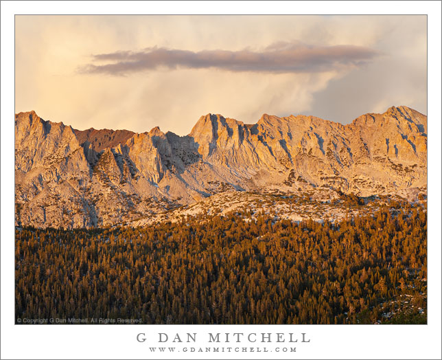
Evening Thunderstorm Above Shepherd's Crest

Evening Thunderstorm Above Shepherd’s Crest. Yosemite National Park, California. September 19, 2011. © Copyright 2011 G Dan Mitchell – all rights reserved.

Evening thunderstorms tower beyond the ridge of Shepherd’s Crest in Yosemite National Park.

There is a bit of a serendipitous story behind this photograph. We were camped at a high lake in the Yosemite backcountry for several days. On the first day the weather was that typical Sierra blue sky weather that can sometimes go on for weeks – beautiful if you live benign weather, but perhaps less appealing to photographers. On the second day, a few small clouds appeared around noon and by evening were becoming quite nice looking above the higher peaks, so we walked up to a higher lake in the evening and did some photography there. On the third day, the little precursor clouds began to show up a bit earlier – perhaps by 11:00 a.m. or even a bit earlier. This tends to get your attention if you have spent time in the Sierra, since clouds that appear that early may have time to develop into full-fledged thunderstorms.

On the second night, one member of our party had visited another little like above our base camp and reported back that it had photo potential. Others decided to visit it early in the morning on day three, though I photographed elsewhere at that time. But when I saw these clouds I thought it might be interesting to get up to this “other little lake” in the evening. Since the route is cross-country I got directions from another member of the group – basically “head up the rocky area, keeping to the right of the bunch of willows in the creek bed, and then head up to the lake. Two members of the group, Charlie and Keith, headed up before me and I followed perhaps 15-20 minutes later.

The climb was enjoyable – while it was steep, the views just got better and better. I ascended the obvious route up the “rocky area,” saw the willows ahead, passed them on my left, and continued on. I soon realized that this was a mistake since instead of a passable route up the lake I encountered a steep rocky wall. Apparently I missed something in the instructions. I probed around a bit and finally found a reasonably safe route up some ledges, carefully marking my return route with rock duck cairns as I ascended, and finally emerged at the top of the steep section… way up the canyon from the likely location of the lake. It was spectacular, but it wasn’t the lake and Charlie and Keith were nowhere to be found.

When traveling alone I tend to be rather conservative and cautious, so I had set a turn-around time that I knew would get me back to camp before complete darkness. That time now arrived, so I back down the little system of ledges, made a few photographs of beautiful high meadows right below them, and started back down toward camp, leaving enough time to stop to make photographs on the descent.

As I passed back down below the rocky wall, the view opened up in front of me and to my right, and included within this panorama was the full length of Shepherd’s crest, with a huge thunderhead and plenty of virga just beyond the ridge. This photograph was made a few minutes before actual sunset when the angle of the light was quite low and the sunset colors were just beginning to glow.

G Dan Mitchell Photography
About | Flickr | Twitter | FacebookGoogle+ | 500px.com | LinkedIn | Email

Text, photographs, and other media are © Copyright G Dan Mitchell (or others when indicated) and are not in the public domain and may not be used on websites, blogs, or in other media without advance permission from G Dan Mitchell.

(Basic EXIF data may be available by “mousing over” large images in posts when this page is viewed on the web. Leave a comment if you want to know more.)