
Tag Archives: face

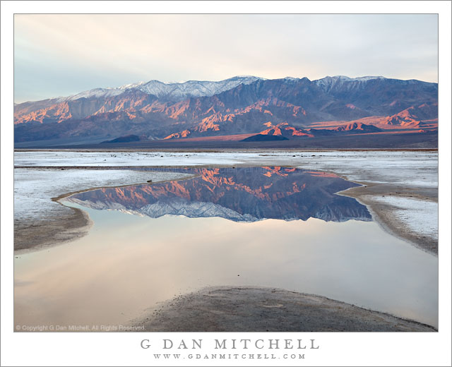
Desert Pool, Panamint Range, Morning

Desert Pool, Panamint Range, Morning

Desert Pool, Panamint Range, Morning. Death Valley National Park, California. February 21, 2011. © Copyright G Dan Mitchell – all rights reserved.

A salt spring pool on the salt flats in Death Valley reflects winter dawn light on the east face of the Panamint Range.

Sometimes I hear people describe how they think or imagine that landscape photography is done, and I wonder where they get their ideas. I will acknowledge that there are many ways to shoot landscape, ranging from working very slowly and carefully to produce a single image, to shooting like crazy and seeing what you end up with. But often people dismiss approaches closer to the latter and assume that the former is the “right way” to shoot landscape.

In my experience it isn’t quite that simple. Sometimes the experience is like certain others in which long stretches of time during which one seemingly accomplishes nothing or perhaps just looks and thinks are suddenly followed by quick and intense spurts of work that come almost as a surprise and may be over as quickly as they begin. This little morning shoot in Death Valley along the edge of a the salt/mud flats where the water from a small salt spring spreads across the flats and forms shallow pools was one of these. Very early in the morning, well before dawn, it was difficult to know what the best shooting option might be. There were clouds in the sky that promised to block the dawn light and everything seemed gray and flat. I wandered a bit, not sure where or what to shoot, and finally, more or less by chance, ended up at this spot that I had visited earlier on this trip. It occurred to me that even if the light wasn’t great I could possibly find a photograph that included this water. So I stopped and began to unpack in no particular hurry.

As I walked across the wash toward the area of the spring, much to my surprise it began to appear that there might be some interesting dawn light after all. I quickened my pace and headed toward the area of the shallow pools, and when I arrived there a moment later I could see some color on the top of the Panamint range. I quickly found a decent foreground pool and as the surprising light worked its way down the front of the range I began photographing. I first made several exposures at much shorter focal lengths, including a larger portion of the sky and the foreground. Then I quickly moved the tripod to place this pool in the center of the frame and hold the reflection of the range. I had little time to contemplate as the light was changing very quickly. I had just enough time to find my composition and make a few exposures, and within moments the light was gone.

G Dan Mitchell Photography | Flickr | Twitter | Facebook | Email
Text, photographs, and other media are © Copyright G Dan Mitchell (or others when indicated) and are not in the public domain and may not be used on websites, blogs, or in other media without advance permission from G Dan Mitchell.
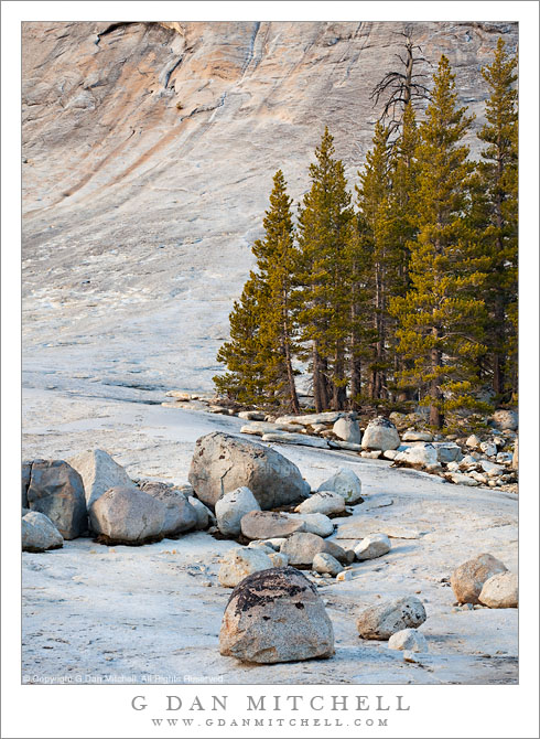
Glacial Erratics and Trees, Lembert Dome

Glacial Erratics and Trees, Lembert Dome

Glacial Erratics and Trees, Lembert Dome. Yosemite National Park, California. June 5, 2010. a© Copyright G Dan Mitchell – all rights reserved.

Glacial erratics and trees at the base of Lembert Dome, Tuolumne Meadows, Yosemite National Park.

This photograph was made last spring in early June, when I drove over Tioga Pass on a quick one-day jaunt right around the time that the road was re-opened for the season after its annual winter closure. The road opened a bit later than usual in 2010 due to above average and late snow fall, and when I crossed there was as much or more snow than I recall seeing up there.

This was one of my marathon drive days. I started well before dawn in the San Francisco Bay Area and arrived in Yosemite in the very early morning and without any concrete plan – except that the ideas of visiting waterfalls and possibly getting up to Tioga Pass were on my mind. I did stop near the Valley first, where I made a series of photographs of Cascade Creek in virtually full flow. After doing this and making a very brief visit to the Valley, I decided to visit the high country along Tioga Pass road. I went just over the pass before turning back. There was so much snow still around that in most places it still looked much more like winter than like early June.

I finally started heading back to the west, as my plan was to return late to the SF Bay Area. As I left the pass and started down toward Tuolumne Meadows the light began to get “interesting” as the sun dropped lower in the west and some high clouds occasionally softened the light. As I drove past Lembert Dome I thought of photographing these glacial erratics that sit on the apron at the bottom of the dome before making one last stop to photograph snow-covered Tuolumne Meadow in the day’s last light.

G Dan Mitchell Photography | Flickr | Twitter | Facebook | Email
Text, photographs, and other media are © Copyright G Dan Mitchell (or others when indicated) and are not in the public domain and may not be used on websites, blogs, or in other media without advance permission from G Dan Mitchell.
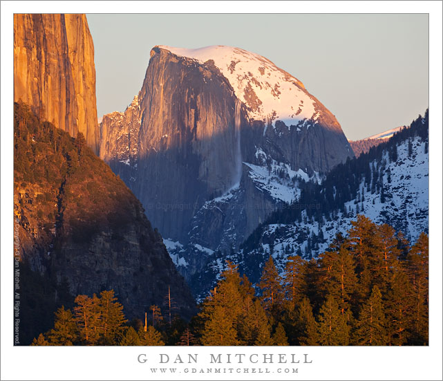
Sunset Avalanche, Half Dome

Sunset Avalanche, Half Dome

Sunset Avalanche, Half Dome. Yosemite National Park, California. January 16, 2011. © Copyright G Dan Mitchell – all rights reserved.

An avalanche breaks loose from the edge of Half Dome as sunset light falls over Yosemite Valley.

Sometimes timing is everything. But, to be honest, luck often plays a bigger part! :-)

On my way out of The Valley on a mid-January weekend, I made this spot my last stop, thinking that I wanted a photograph from this angle at sunset with snow on Half Dome. (I have a number of photographs of this location, but mostly from the warmer months of the year. ) I know this spot well enough at this point that I know pretty much exactly where to be and when to be there, and this was no exception. On the way up here I first stopped to photograph some trees on a ridge across the Valley, something I worked on more than once during this trip. When the last light left those trees I headed on up the road to this overlook and arrived perhaps a full half hour before the start of the real light show. I hung out a bit, ate a snack, and eventually set up.

I never know exactly what will happen here, believe it or not, even though I understand the process pretty well. The foreground right ridge first falls into shadow, then the shadow line begins to creep up toward the face of Half Dome and rise up the rocky slope in front of El Capitan at the left. But what the sky will do during this transition is quite variable. Sometimes the sunset simply dies out with a whimper. On other evenings the light goes through a remarkable sequence of transitions. That is what finally happened on this evening. Eventually I’ll share some of the other photographs from this evening, but for now I’ll just share a hint or two. The color of the sky behind Half Dome transitioned from blue to pink and purple and finally to a deep blue that verged on purple.

But the real surprise – and one I did not realize I had captured it until I got home and looked closely at my raw files – was that one of the images contained a sort of “Yosemite Fall” that I had never seen before, namely the “snow fall” created as a large piece of the snow field near the edge of Half Dome let loose after a day of warm sun and cascaded down the right face of the mountain… just as sunset light split the dome! I suppose this provides yet another opportunity to quote Ansel, who apparently once said, “Sometimes I do get to places just when God’s ready to have somebody click the shutter.”

This photograph is not in the public domain and may not be used on websites, blogs, or in other media without advance permission from G Dan Mitchell.

G Dan Mitchell Photography
FlickrTwitter (follow me) | Facebook (“Like” my page) | LinkedInEmail

Text, photographs, and other media are © Copyright G Dan Mitchell (or others when indicated) and are not in the public domain and may not be used on websites, blogs, or in other media without advance permission from G Dan Mitchell.


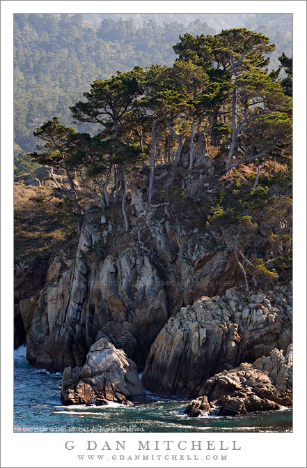
Monterey Cypress and Coastal Cliffs at Bluefish Cove

Monterey Cypress and Coastal Cliffs at Bluefish Cove

Monterey Cypress and Coastal Cliffs at Bluefish Cove. Point Lobos State Reserve, California. January 8, 2010. © Copyright G Dan Mitchell – all rights reserved.

Monterey Cypress trees grow atop cliffs above Bluefish Cove at Point Lobos State Reserve.

One fun thing about photographing places that I have visited for nearly my full life is that it sometimes encourages me to learn things about places that I had taken for granted – like names of features and places. Although I’ve been to Point Lobos since I was a child and I have seen this area of the reserve many times, I had no idea there was a place called Bluefish Cove, much less that this was it. More accurately, the small patch of water at the foot of this wonderful bit of rocky cliff and cypress forest is Bluefish Cove. I am surprised to note that the point itself seems to be unnamed, at least according to several maps I checked, each of which names many lesser places. The ridge rises from the water to form a peninsula between Bluefish Cove and the larger Whalers Cove. Beyond and above are some of the first coastal hills at what I think of as the north end of the Big Sur coastline.

This photograph is not in the public domain and may not be used on websites, blogs, or in other media without advance permission from G Dan Mitchell.

G Dan Mitchell Photography
FlickrTwitter (follow me) | Facebook (“Like” my page) | LinkedInEmail

Text, photographs, and other media are © Copyright G Dan Mitchell (or others when indicated) and are not in the public domain and may not be used on websites, blogs, or in other media without advance permission from G Dan Mitchell.