
Tag Archives: point

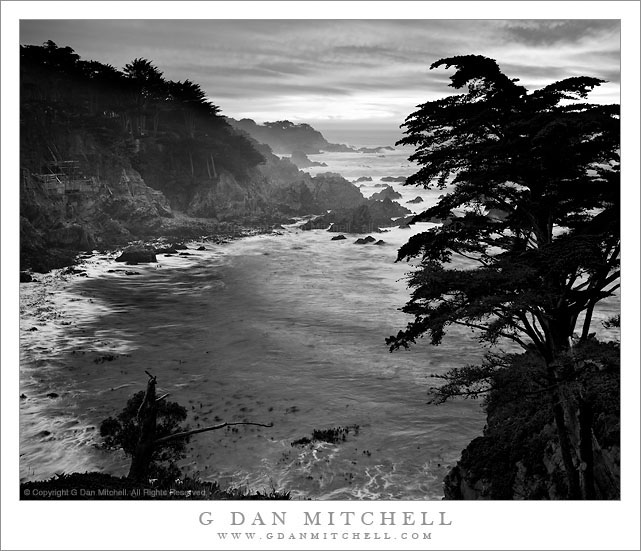
Yankee Point and Cypress, Carmel Highlands, Dusk

Yankee Point and Cypress, Carmel Highlands, Dusk

Yankee Point and Cypress, Carmel Highlands, Dusk. Big Sur, California. January 2, 2010. © Copyright G Dan Mitchell – all rights reserved.

A Carmel Highlands cypress trees stands at the edge of a cliff above the Pacific Ocean and Yankee Point at dusk.

Oddly, this is a photograph that sort of “didn’t make the cut” the first time I went through the batch shortly after making the photographs in early 2010. I had spent the afternoon photographing further south in the Big Sur area and several other photographs from the set turned out more as I expected – and this one seemed like a sort of problem child photograph, so I didn’t take the time needed to work with it. Eventually I forgot about it as I went on to other projects.

The photo had been almost a bit of a grab shot. As I was heading north back up the coast, thinking I had finished my shooting and was now on the way home, I was stunned to catch a glimpse of some intense post-sunset light as I rounded the bend at the head of this cove in Carmel Highlands. I wasn’t certain that I could find a composition and work out a photograph in the brief interval the probably remained before the light faded, but I quickly put on the wide angle zoom, attached the camera to the tripod, and headed over to the edge of the bluff. Exposure was a terrible problem because the brilliant and very colorful sky was quite bright, while the close side of the foreground tree was nearly black. I made managed to shoot the scene a few times, shifting from landscape to portrait mode and making three bracketed exposures of each composition.

When I got home and looked at the raw files I think I decided that it was just going to be too much work for too little reward, and I instead went to work on more promising shots from earlier in the afternoon. This week I came upon the series of shots again and wondered what I could do with them. My first inclination was to go with the color, and I did come up with a portrait orientation image in color that I will probably post before long. Then, as I began to work on the landscape mode image, I started to see it as having potential as a monochrome image. I tried it. I liked it. And here it is!

This photograph is not in the public domain and may not be used on websites, blogs, or in other media without advance permission from G Dan Mitchell.

G Dan Mitchell Photography
Flickr | Twitter | Facebook Fan Page | Facebook | Friendfeed | Email

Morning Clouds Above the Manifold, Zabriskie Point

Morning Clouds Above the Manifold, Zabriskie Point

Morning Clouds Above the Manifold, Zabriskie Point. Death Valley National Park, California. April 2, 2007. © Copyright G Dan Mitchell – all rights reserved.

Morning clouds fill the sky above the Manifold at Zabriskie Point, Death Valley National Park.

I posted a monochrome version of this photograph yesterday, so there is perhaps a bit less to say about it in this post. To recap briefly, this is a photograph I made over three years ago during a spring visit to Death Valley NPS. This was a bit of a different morning for photographing at Zabriskie Point, if I recall correctly. Usually, photographing here is pretty straightforward – and once you’ve shot it a couple times in “normal” conditions, there is a basic pattern to the progression of light that becomes fairly (though perhaps not totally) clear. Normal conditions here basically mean perfectly clear skies with the sun coming up to the left from the perspective of this photograph or behind in some of the other familiar shots that include Manley Beacon – and light that sequentially illuminates subjects beginning with the highest peaks of the Panamint Range across the Valley and gradually working down into the Valley and finally to the rugged shapes at Zabriskie Point itself.

But clouds can change everything. If I am going to shoot at Zabriskie, I watch for conditions that will bring them. I will generally not stop there if it is “another beautiful clear sunrise” at Zabriskie. (If you haven’t been there before, you should stop and take in this stunning scene, but I’m often looking for something a bit different.) While the results in clear conditions are relatively predictable, they are not at all as predictable when there are clouds. You can end up with something very special… or with a drab, flat, and gray scene. But that’s the thing about special conditions – they wouldn’t be special if they were predictable and frequent!

Thinking back to this morning, my recollection is that it may have been one of those when I arrived to think, “Oh, boy, clouds!” – only to think a bit later, “I wish those clouds would move and give me some light!” I recall some bits of dawn light that were mostly blocked by the clouds. But the very clouds that blocked the hoped-for first dawn light thoughtfully assembled themselves into these impressive forms just a bit later, at right about the time that the warm side-light was getting down into the rugged folds of the Manifold and Gower Wash.

This photograph is not in the public domain and may not be used on websites, blogs, or in other media without advance permission from G Dan Mitchell.

G Dan Mitchell Photography
Flickr | Twitter | Facebook Fan Page | Facebook | Friendfeed | Email

Morning Clouds Above the Manifold, Zabriskie Point

Morning Clouds Above the Manifold, Zabriskie Point

Morning Clouds Above the Manifold, Zabriskie Point. Death Valley National Park, California. April 2, 2010. © Copyright G Dan Mitchell – all rights reserved.

Morning clouds fill the sky above the Manifold at Zabriskie Point, Death Valley National Park.

This photograph is not in the public domain and may not be used on websites, blogs, or in other media without advance permission from G Dan Mitchell.

Recently I’ve been going over some of my Death Valley photographs, and as I do so I discover a few that “missed the cut” the first time around but which I kind of like now when I see them a few years later. This photograph was made in 2007, on a spring morning when beautiful clouds filled the sky above Zabriskie Point and Death Valley. I have versions of this photograph in both black and white and color – I like both, though the effect is quite different. (I’ll post the color version as soon as tomorrow.)

I’ve referred to the striking central feature of the “badlands” above Gower Wash – the hill with the curving gullies and the darker material along the top – as “the Manifold” for a few years. I know I saw this label applied to the feature somewhere, but I cannot find the source now. In any case, it seems deserving of its own name, and “the Manifold” works for me.

One more observation… I have written elsewhere about my attitude toward photographing iconic scenes – an Zabriskie Point is certainly iconic! It is a bit of a long, complicated story, but this photograph illustrates part of my philosophy. I will not always bother to stop and photograph such a site, having seen many beautiful mornings (and a few evenings) there. But I do watch for special or unusual conditions, and when they occur I may well head to an icon like Zabriskie to try to make a photograph that is unlike the usual images.

Since I am in the process of reviewing many Death Valley photographs, don’t be too surprised if a few more older photos from that location show up here soon.

G Dan Mitchell Photography
Flickr | Twitter | Facebook Fan Page | Facebook | Friendfeed | Email
Black Point and Negit Island, Mono Lake Shoreline

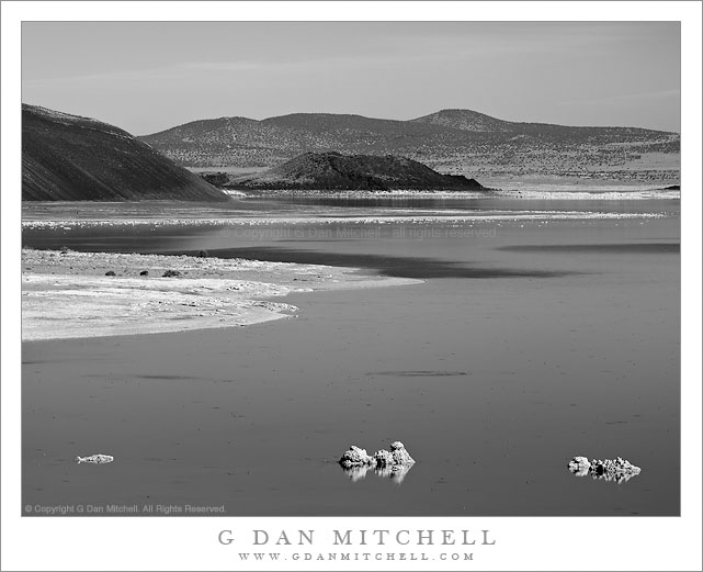
Black Point and Negit Island, Mono Lake Shoreline

Black Point and Negit Island, Mono Lake Shoreline. Mono Lake, California. October 10, 20120. © Copyright G Dan Mitchell – all rights reserved.

The north shoreline of Mono Lake leads from foreground offshore tufa past the base of Black Point to Negit Island and beyond.

You would never know it from this black and white photograph of the austere desert landscape around Mono Lake, but I was there to photograph… fall aspen color! Earlier in the day I had photographed further south along the eastern slopes of the Sierra, gradually working my way north with a plan of heading back to the “west side” over Tioga Pass at the end of the day after doing a last bit of  fall color photography near Conway Summit and Dunderberg Road in late-afternoon light. By mid-afternoon I had made it to Lee Vining for an espresso stop at Latte Da and a break to check some email and so forth. Soon it was time to get into position for the low angle sun that would light the aspens a bit later, so I headed north out of town.

The road north from Lee Vining skirts the west shore of Mono Lake. Before leaving the lake there is a turn-off to another road that passes along the north shore of Mono Lake and can take you to places such as Black Point. I often stop at this turn-off since it provides a slightly elevated view of the larger terrain around the lake including the low hills to the east and Mono Craters and higher mountains to the south. On a typical blue sky mid-afternoon I might not make any photographs, but something about the light and the forms of the shoreline, Black Point, and Negit Island leading into the distance convinced me to make a few exposures, using a long lens to compress the distance.

This photograph is not in the public domain and may not be used on websites, blogs, or in other media without advance permission from G Dan Mitchell.

G Dan Mitchell Photography
Flickr | Twitter | Facebook Fan Page | Facebook | Friendfeed | Email