Tag Archives: hills

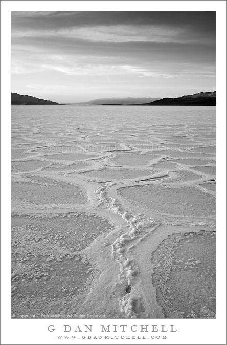
Salt Flats Near Badwater, Evening

Salt Flats Near Badwater, Evening

Salt Flats Near Badwater, Evening. Death Valley National Park, California. March 29, 2010. © Copyright G Dan Mitchell – all rights reserved.

Black and white vertical format photograph of evening on the salt flats of Badwater Basin, Death Valley National Park, California.

Yes, I’m still mining the Death Valley photographs from my late March trip. And there are more to come… :-)

This photograph was made in evening light on the salt flats of Badwater Basin, not far from the “official” Badwater area – but far enough away that there were only a couple other photographers out here enjoying the solitude and the beautiful evening light. A few weeks earlier this area had been flooded by unusually heavy rains in Death Valley. From all appearances (and from photographic evidence that I’ve seen) the photographers who were first on the scene had to do a bit of wading to get out onto the salt flats. Some of them were rewarded for their efforts with wonderful and unusual images, including reflections of the Panamint range in the circular pools between the polygons of raised salt.

By the time I arrived the area was no longer flooded, though it was clear that the playa beneath the drying salt crust was still wet. In places some of the water appeared in cracks and in other spots walking on the salt felt a lot like walking on winter pond ice. During the flooding, the usually tall ridges between the salt “polygons” seem to have dissolved. Typically they are perhaps up to a few inches tall and contain large cracks. At the time I arrived, the counter had apparently been set back to zero – and the salt surface was almost completely flat, though it is obvious that the polygon outlines were still visible and beginning to rise a bit. The vertical ridge leading away from the camera position in the lower portion of the frame is a good example.

I went with black and white in this rendition since the sky had not really lit up yet – in other words, color wasn’t necessarily the main feature of the scene. I also liked what I could do with the clouded sky and the distant ridge in black and white.

This photograph is not in the public domain and may not be used on websites, blogs, or in other media without advance permission from G Dan Mitchell.

G Dan Mitchell Photography | Twitter | Friendfeed | Facebook | Facebook Fan Page | Email

Technical Data:
Canon EOS 5D Mark II
Canon EF 24-105mm f/4 L IS USM at 35mm
ISO 100, f/16, 1/25 second

keywords: salt, flat, polygon, pattern, landscape, nature, geology, hills, mountains, sky, dark, clouds, evening, dusk, sunset, haze, atmosphere, light, shadow, badwater, basin, death valley, national, park, california, usa, north america, travel, scenic, black and white, monochrome, texture, curve, stock

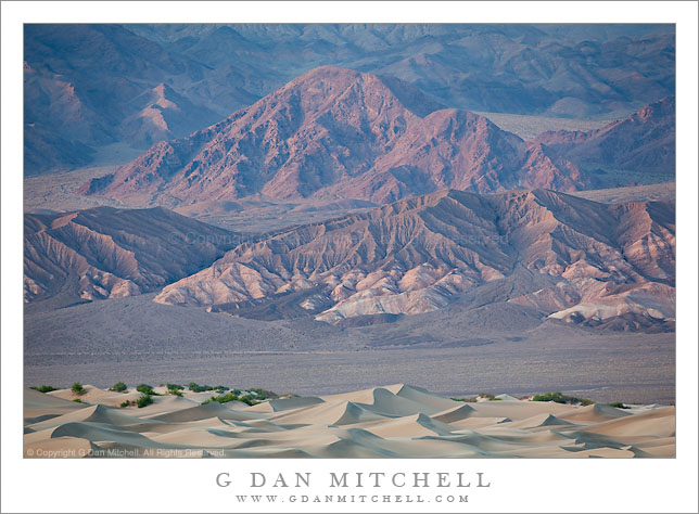
Amargosa Range and Transverse Dunes, Sunset

Amargosa Range and Transverse Dunes, Sunset

Amargosa Range and Transverse Dunes, Sunset. Death Valley National Park, California. March 26, 2010. © Copyright G Dan Mitchell – all rights reserved.

Sunset light on lower reaches of the Amargosa Range and the Kit Fox Hills above the Transverse Dunes, Death Valley National Park, California.

The Amargosa Range lies east of Death Valley and the Death Valley Dunes, and its foothills (called the “Kit Fox Hills,” if I’m not mistaken) here from a backdrop for the “transverse dunes,” the lower eastern portion of the Death Valley Dunes near Stovepipe Wells. The dunes turn all sorts of interesting colors at and just after sunset on evenings when the light is just right, and the evening light brings out colors in the further hills and gullies that are generally washed out in the harsh midday light.

To get an idea of the scale of the scene consider that the photograph was made with a rather long focal length of nearly 400mm and that the very subtle line along the base of the hills is the roadway running north towards Scotty’s Castle. Walking out to the dunes along the lower edge of the photograph might take a half hour or so.

This photograph is not in the public domain and may not be used on websites, blogs, or in other media without advance permission from G Dan Mitchell.

G Dan Mitchell Photography | Twitter | Friendfeed | Facebook | Facebook Fan Page | Email

Technical Data:
Canon EOS 5D Mark II
Canon EF 100-400mm f/4.5-5.6 L IS USM at 370mm
ISO 200, f/8, 1/50 second

keywords: kit fox, hills, mountains, amargosa, range, alluvial, fan, desert, transverse, dunes, mesquite, gully, geology, grapevine, foothills, shadow, sunset, dusk, wash, evening, death valley, national, park, california, usa, north america, travel, scenic, wilderness, landscape, nature, barren, light, stock

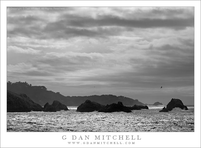
Incoming Winter Storm, Point Lobos

Incoming Winter Storm, Point Lobos

Incoming Winter Storm, Point Lobos. Point Lobos State Reserve, California. January 10, 2010. © Copyright G Dan Mitchell – all rights reserved.

Black and white photograph of the leading edge of a winter storm passing over the Pacific coastline at Point Lobos State Reserve, California.

On this morning I thought the weather was going to be too rainy and cloudy to shoot – and I slept it. When I got up and saw that maybe it wasn’t going to be quite that bad I made a quick decision to head south and out toward the coast, and ended up at Point Lobos. The huge storm surf was beating against the coast and the leading edge of the incoming cold front was just passing over the coastline, putting some impressive clouds about the coast and the spray/mist from the big waves, and letting me shoot almost straight toward the sun.

Not all of my black and white photographs start out that way. In truth, while I sometimes have a pretty good idea that a particular shot is heading in the monochrome direction when I make the exposure, with other images I don’t “discover” this until I begin my work in post. With this one I had a pretty clear idea that the clouds and that receding layers for rock and bluff would work in black and white.

This photograph is not in the public domain and may not be used on websites, blogs, or in other media without advance permission from G Dan Mitchell.

G Dan Mitchell Photography | Twitter | Friendfeed | Facebook | Facebook Fan Page | Email

keywords: point, lobos, state, reserve, park, california, usa, pacific, ocean, sea, coast, shore, carmel, highlands, big, sur, rocks, islands, sea stacks, surf, wave, rough, reflection, sun, light, winter, season, storm, front, edge, leading, cloud, sky, seascape, landscape, nature, scenic, travel, hills, cliff, bluff, bird, gull, cypress, trees, forest, weather, stock

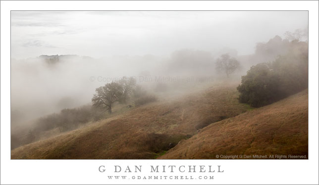
Winter Fog and Oak Covered Hills

Winter Fog and Oak Covered Hills

Winter Fog and Oak Covered Hills. Calero Hills, California. January 9, 2010. © Copyright G Dan Mitchell – all rights reserved.

Winter morning fog settles over the oak covered Calero Hills landscape of central California.

On this early-January winter morning I headed to my “photographic backyard” in the Calero Hills area, knowing that I’d get to shoot my favorite hills, oak trees, and grasslands in fog, clearing fog, and perhaps even sunlight. Things didn’t pan out exactly as I expected, but it was a good morning of photography anyway.

After starting out by photographing a tree in the “lowlands” of the park, I could tell that the tule fog was starting to clear a bit along the ridges – the brighter light from above was one hint, and the occasional faint sight of blue sky and clouds through the low fog was another. So I decided to finish up my work on that tree and follow a trail that ascends to one of the many minor ridges running through the park.

Arriving at a familiar point on the ridge along a valley that drops away to the south, the fog began to clear from my location. I soon discovered that it wasn’t going to be a day for sunlit photographs – a weak weather system was approaching and high clouds muted the sunlight. In addition the fog didn’t exactly clear – it was more a case of the fog sort of washing back and forth. One moment my position and nearby ridges would clear and I’d see the overcast sky above (as in this photograph), but a few minutes later another wave of fog would expand out of the valleys and I’d be socked in again. So I set up and waited and watched and ended up with several photographs that I like.

This photograph is not in the public domain and may not be used on websites, blogs, or in other media without advance permission from G Dan Mitchell.

G Dan Mitchell Photography | Twitter | Friendfeed | Facebook | Facebook Fan Page | Email

keywords: calero, county, park, santa clara, california, usa, hills, oak, tree, grove, grass, brown, golden, valley, fog, mist, clouds, silhouette, nature, ridge, mountain, sky, winter, season, central, grassland, emerge, clear, settle, landscape, soft, light, rock, plant, stock