Tag Archives: overlook

Green River Canyon, Evening

Green River Canyon, Evening
“Green River Canyon, Evening” — Soft evening light on the canyon of the Green River as it winds through the desert terrain of Canyonlands National Park, Utah

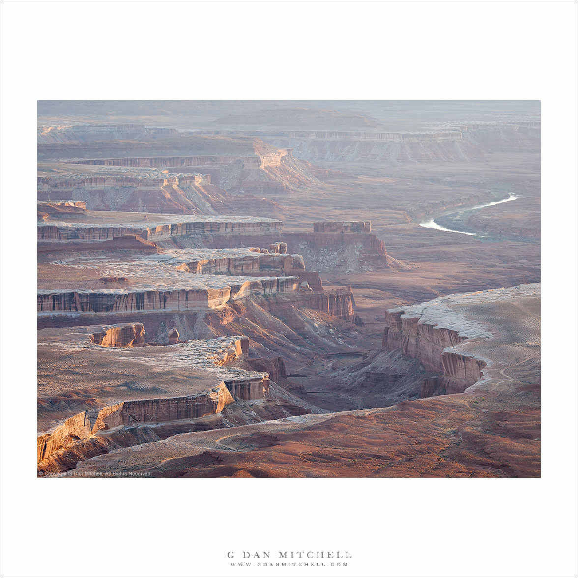
I recently returned from a week in Utah which, perhaps surprisingly, was completely new to me as a photographic subject. More about that in a moment, but first a description of the photograph. It was made in Canyonlands National Park in the “Island in the Sky” area, looking west from a high viewpoint above the canyon containing the winding Green River, not far above its confluence with the Colorado River. The “Island” is a high and relatively flat plateau at around 6000+’ of elevation, surrounding on many sides by deep canyons, cliffs, and then several levels of lower plateaus. There are “edges” everywhere, and all of them provide stunning vistas into the vast spaces below and beyond. We ended up at this spot largely due to a photograph I had seen an a park brochure that included a view of receding mesas and canyons in evening light. We scouted it in the middle of the afternoon as we visited several places in this area of the park, and it seemed inevitable that I would end up at sunset. I initially imagined a scene with brighter colors from the sunset and the post-sunset sky, but instead I ended up with something that I think I like even more, namely softer light with haze in the atmosphere and somewhat gentler colors.

As I mentioned above, I have not photographed in Utah before. I had been through the state several times many years ago, but I think we more or less sped through on interstate highways – which don’t tend to follow the most scenic routes – and I had a very limited view of the place. While it is too bad that I waited so long to go there, it gave me the opportunity to have an experience that I don’t have nearly as often in California where I do most of my shooting. Because I live within a short drive of redwood forests, the Pacific coast, and places like Yosemite Valley and the Sierra and visit all of them frequently, I have to admit that I sometimes forget how extraordinary they are. I can drive right past Yosemite’s Tunnel View if the view is just a typical Yosemite Valley view. But on this trip, I more or less intentionally avoided investigating our destinations before we left. Consequently, I had opportunities to be surprised and astonished — like any good tourist! — by things that I was seeing for the first time. For example, I really had no idea what I would see at Arches National Park when we drove into it at just about the “golden hour” – and I was completely stunned by impossible structures and juxtapositions of sandstone columns and arches and towers and cliffs. I just got a quick taste on this trip… but I’ll be back.

G Dan Mitchell is a California photographer and visual opportunist. His book, “California’s Fall Color: A Photographer’s Guide to Autumn in the Sierra” (Heyday Books) is available directly from him. Blog | Bluesky | Mastodon | Substack Notes | Flickr | Email

Join the discussion — you are welcome to leave a comment or question. (Comments are moderated and may not appear immediately.)

This site uses Akismet to reduce spam. Learn how your comment data is processed.

(All media © Copyright G Dan Mitchell and others.)

‘Rim of the World’ Overlook, Morning

'Rim of the World' Overlook, Morning

‘Rim of the World’ Overlook, Morning. Sierra Nevada, California. May 7, 2011. © Copyright G Dan Mitchell – all rights reserved.

The view toward Yosemite and the High Sierra from the ‘Rim of the World’ overlook above the Tuolumne River canyon along highway 120.

‘Rim of the World’ is the name given to a scenic overlook above the deep valley of the Tuolumne River along route 120, the northern route into Yosemite National Park. It is something of an odd place. It is a fairly pedestrian traffic pullout, though it overlooks the immense and impressively deep canyon of the Tuolumne. But the view is at least partially obstructed by things like power lines. However, it is a view that on clear days can extend great distances to very high Sierra peaks.

I most often simply blow past the spot on my way to or from the park. However, on this morning as I passed I thought the low morning light looked interesting so I found a spot to turn around and drove back. There was a bit of high cloudiness, and the light was coming across the folds of these foreground hills from the right, lighting up various bits of ridge and trees and illuminating the morning haze enough to amplify the effect of distance. If I’m not mistaken, the further ridge with its faintly seen snow fields is in the area of Mount Hoffman.

G Dan Mitchell Photography | Flickr | Twitter (follow me) | Facebook (“Like” my page) | LinkedIn | Email
Text, photographs, and other media are © Copyright G Dan Mitchell (or others when indicated) and are not in the public domain and may not be used on websites, blogs, or in other media without advance permission from G Dan Mitchell.

Cove and Beach Near Davenport, Evening

Cove and Beach Near Davenport, Evening

Cove and Beach Near Davenport, Evening. Davenport, California. December 12, 2010. © Copyright G Dan Mitchell – all rights reserved.

Black and white photograph of two people standing on a bluff above the Pacific Ocean and overlooking a cove and beach near Davenport California.

Although I have continued posting photographs at a rate of one per day, I have only managed to get into the field to shoot a few times since early November. Yesterday I found time to make it over to the Pacific coast late in the day. I was looking for the foggy, misty, and somewhat gray conditions that are common this time of year, at least when the air has not been cleared by a passing storm. I wasn’t disappointed. While the sky was clear overhead, the air was very moist – my equipment became damp from condensation as I worked.

Since my time was a bit limited – the sun was going down! – I went more or less straight to this spot where I have photographed in the past. (At first I considered going a bit further north to shoot from high bluffs, but I realized that the shot I had in mind from that location would be better earlier in the day.) When I arrived the sun was just dropping below the horizon, but that is what I wanted – I wasn’t looking for one of those brilliant “sun dead ahead” shots. I wanted the post-sunset soft light and enough darkness that I could work with longer exposures.

I parked and walked the short distance to this spot at the head of this cove. The composition is sort of tricky. The “right” (in my view) arrangement of the offshore rock and the surrounding bluffs can only be seen from a very small area – too far right or left and elements start to collide. In addition I wanted that little bit of more distant shoal along the right side of the frame to suggest that the coast continues, and I wanted that flat bit of bluff with a bit of post sunset light at the left. It was a bonus when the two people – probably photographers! – showed up on the top of the left bluff and thoughtfully posed for me as I made long exposures!

This photograph is not in the public domain and may not be used on websites, blogs, or in other media without advance permission from G Dan Mitchell.

G Dan Mitchell Photography
Flickr | Twitter | Facebook Fan Page | Facebook | Friendfeed | Email

Folds and Strata, Zabriskie Point

Folds and Strata, Zabriskie Point

Folds and Strata, Zabriskie Point. Death Valley National Park, California. March 29, 2010. © Copyright G Dan Mitchell – all rights reserved.

Convoluted folds topped by some stratified material at Zabraskie Point, Death Valley National Park, California.

A new hobby for me when photographing Zabriskie Point is to forego the famous panoramic views of Manley Beacon and the Panamints – well, at least sometimes – and to instead focus on smaller details of the patterns in the fantastically folded terrain. Starting about a year ago, I also became intrigued by the idea of shooting here at unusual times of the day: late morning, early afternoon, and so forth. I started doing this when a year ago I shot somewhere else at dawn and then happened to stop her much later in the morning – only to discover that some of the shapes and forms that are in shadow early in the day are actually better-lit later on.

On my late-March trip I did shoot Zabriskie at the “popular” time of dawn on one morning, but on another day I spent a good amount of time shooting here during the less classically ideal time in the middle of the afternoon. I was lucky enough to get just a bit of high thing clouds which reduced contrast just a bit, but kept the interesting shadows and illuminated ridges that appear at this time of day. When I shoot this way I go straight for a very long lens and focus on smaller details of the scene, ignoring the larger and broader landscape in favor of bits of a gully, shadowed or sunlit ridges, or a bit of strata material sitting on top of the folded material as seen here.

Rather than amp up the contrast and saturation – an easy trap to fall for in the afternoon light – I decided to keep the softer and less saturated effect that I was actually there when I made the photographs.

This photograph is not in the public domain and may not be used on websites, blogs, or in other media without advance permission from G Dan Mitchell.

G Dan Mitchell Photography | Twitter | Friendfeed | Facebook | Facebook Fan Page | Email

Technical Data:
Canon EOS 5D Mark II
Canon EF 100-400mm f/4.5-5.6 L IS USM at 250mm
ISO 100, f/16, 1/30 second

keywords: zabriskie, point, death valley, national, park, california, usa, north america, nature, landscape, geology, scenic, travel, form, formations, fold, gully, rock, strata, material, shadow, light, abstract, view, ridge, hill, manifold, overlook, desert, barren, stock